Telangana SCERT 8th Class Social Study Material Telangana Pdf 1st Lesson Reading and Analysis of Maps Textbook Questions and Answers.
TS 8th Class Social 1st Lesson Questions and Answers – Reading and Analysis of Maps
Improve Your Learning
Question 1.
Study the School atlas carefully by looking at various thematic maps.(Mapping skills)
Answer:
Map which focuses only one aspect is known as thematic map. For Eg:
Question 2.
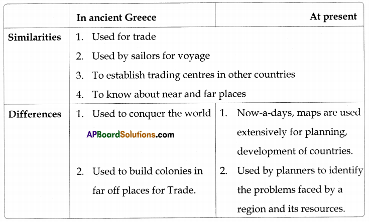
Do you think the use of maps has changed from the time of ancient Greeks to now? In what way are they similar and different? (Conceptual understanding)
Answer:
Question 3.
Many people believe that making of maps by the Colonial powers was a more powerful tool for exploitation and control of the colonies than guns. Do you agree? Why? (Conceptual understanding)
Answer:
Yes, I agree that making of maps by the Colonial powers was a more powerful tool for exploitation and control of the colonies than guns.
1. When the European powers colonized the entire continents like North and South Americas, Africa, Australia and Asia they needed to know about the places, their climate, crops, mineral resources and about the people living there.
2. They sent scientific expeditions consisting of map makers and others to explore the different parts of the world and prepared maps about the places where mines are available and on different subjects.
3. This helped colonial powers to capture the colonies with other tactics more than by wars. In a way, they learned about shortcuts to forests and hills better than the native rulers using the maps and established power instead of by wars.
![]()
Question 4.
In what ways were the maps prepared by the British different from the one made by Ptolemy? (Mapping skills)
Answer:
The differences between maps prepared by the British from the ones prepared by Ptolemy or Idrisi are given below.
| British maps | Ptolemy maps |
| 1. More accurate maps showing north on top. | Ptolemy said that the earth is the center of the universe and the stars, sun, and planets revolve around it which was proved wrong later by Copernicus. |
| 2. They made detailed maps of the interiors of the country. | He did not know about the interior places. |
| 3. India was shown larger than Sri Lanka. | India was shown much smaller than Sri Lanka. |
| 4. Britishers showed all the continents in their maps. | Only Asia and Africa in his maps. |
| 5. Maps were designed based on 0° latitude of the earth. | Maps were designed by centralizing Greece or Rome and Arabia. |
Question 5.
Read the paragraph “Use of maps in our times” on page 8 and answer the following question:
As we saw above, maps were made and used for a variety of purposes: for trade, sailing, for conquests and colonising and for fighting wars. In our own times maps are used extensively for planning, development of countries. This requires planners to identify the problems faced by a region and its resources etc. This is done with the help of maps. For example, we can make a map of regions which have very little drinking water.
We can compare this map with maps showing water resources – rainfall, groundwater, and rivers. Based on this comparison we can decide what is the best way to make drinking water available to all the people of the region – by sinking tube wells, or building dams across streams or making tanks (cheruvus) or bringing water from distant places in large pipes. Similarly, we can plan agricultural development, setting up new industries, building roads, hospitals and schools with the help of maps.
Maps are also used by companies to plan their business work. For example, a mobile telephone company that wants to spread its network in an area will need maps of villages and towns and about hills and forests to set up microwave towers. What are the various purposes for which maps are used in our times? (Reading the text (given), understanding and interpretation)
Answer:
The various purposes for which maps are used in our times are as follows:
- For trade, sailing, for conquests and colonizing and for fighting wars.
- For planning, development of countries.
- For comparison between regions having less and abundant water resources. Based on this comparison) we can decide the best way to make drinking water available to all the people of the region.
- We can plan agricultural development, setting up new industries, building roads, hospitals and schools.
- For companies to plan their business work.
Question 6.
Prepare a few questions to find out more about different types of maps. (Mapping skills)
Answer:
- How can we know the exact distance of different places using maps?
- What are the symbols used to identify different places like railway stations, projects, rivers etc?
- If one wants to know about different countries, what kind of maps are to be verified?
- How many types of maps are there?
- How to know the details of historical places in present maps?
- What is the importance of colours in thematic maps.
Intext Questions
Text Book Page No. 1
Question 1.
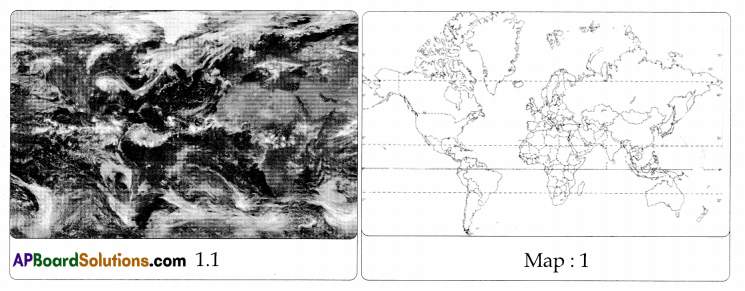
Can you point out the difference between a map and a photograph of the same place taken from the sky? For example look at the photograph (Fig 1.1) and the map (Map 1) of the same place. Can you point out all the similarities and differences between the two? (Mapping skills)
Answer:
The photograph taken from the sky and the map drawn, both show the oceans and continents. However, the map shows the clear division of countries which is not possible with the photo taken from sky.
Question 2.
Can you point out all the similarities and differences between a map and a photograph?
Answer:
| Differences | Map | Photograph |
| 1. It doesn’t show real features 2. It is used by geographers to show features that we consider important. Eg Population, soil types |
1. It shows real features
2. It is more appearing to eyes and represents as it is in appearance. |
|
| Similarities | 1. Both are attractive and kindle interest by means of giving information. 2. The given photo and map are not to scale, much information can not be given. |
Text Book Page No. 4
Question 3.
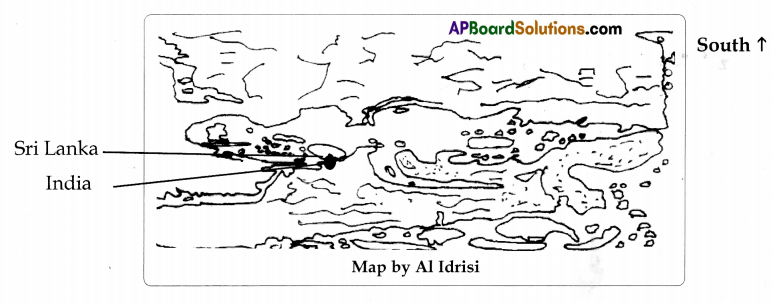
a) Can you guess why? Turn the book around. Can you now locate India and Sri Lanka (Which was shown much bigger than it is)!(Conceptual understanding)
Answer:
1. As the earth is round, one cannot make clear divisions of directions. Hence, Al Idrisi might have taken south on top just for convenience’s sake or coinciding with his Islam religious beliefs.
2. Most of us use right-hand side instead of left-hand. If we stand opposite to sun, our right-hand points towards south. So, A1 Idrisi might have taken south preferring right hand.
3. Al Idrisi might have followed Islamic tradition.
Text Book Page No. 5
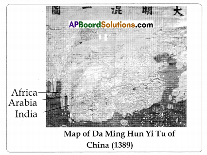
b) Can you identify India, Arabia, and Africa in the Map? (Mapping skills)
Answer:
Text Book Page No. 6
Question 4.
In what ways do you think did the sailors influence the making of maps in early times? (Conceptual understanding)
Answer:
Sailors needed correct directions and shapes so that they could identify the landmarks. In order to help the sailors the maps had to be accurate. The sailors also helped the map makers by telling them about the places they visited in their voyage and giving information of islands, hills, streams, etc. Hence they influenced the making of maps in early times.
Question 5.
Why do you think did the map makers place their own country in the middle of the map? (Conceptual understanding)
Answer:
Ancient mapmakers did not know the shape of the Earth. So, taking their country as the center, they drew the maps with the places what they visited and saw.
![]()
Question 6.
Why do you think that in Idrisi’s map the top side points to the south while in the maps prepared by the Greeks, it pointed to the North? (Conceptual understanding)
Answer:
1. As the earth is round, one cannot make clear division of directions. Hence, Al Idrisi might have taken south on top just for convenience’s sake or coinciding with his religious beliefs.
2. Most of us use right-hand side instead of left-hand. If we stand opposite to sun, our right-hand points towards south. So, Al Idrisi ought have taken south preferring right hand.
3. Al Idrisi might have followed Islamic tradition.
4. Greeks might have taken the movement of sun important. They might have taken east the rising sun’s direction and decided the remaining directions, so north on top.
Text Book Page No. 8
Question 7.
Do you think this free access to maps is a good thing? Why? (Conceptual understanding)
Answer:
Yes, because maps are widely used by everyone today for various purposes. For example, thematic maps are used by people to know a lot of information. Hence it is a good thing to make maps accessible freely.
Question 8.
Why do you think did the colonial powers invest so much money to prepare detailed maps? (Information skills)
Answer:
- The colonial powers invested so much money to prepare detailed maps ot North and South Americas, Africa, Australia, and Asia about the climate, crops, mineral resources, and the people living in those places.
- Hence, this information provided in the maps enabled the colonial powers to establish their rule over other countries and also exploit their resources.
Question 9.
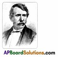
Find out about the lives of some of the great explorers like David Livingstone, Stanley, Amudsan etc. Find out who sponsored their expeditions and why. (Appreciation and Sensitivity)
Answer;
David Livingstone :
1. David Livingstone was born on March 13, 1813, in Blantyre, Scotland, near Glasgow.
2. He became a doctor and a missionary and devoted much of his life in exploring Africa.
3. He first went to Africa as a Christian missionary in 1841, when he was 27 years old. He decided that the best way to teach Africans about Christ was to move about and see as many people as he could. That is how he became an African explorer.
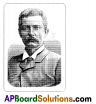
Sir Henry Morton Stanley:
1. Sir Henry Morton Stanley (28 January 1841 – 10 May 1904), was a Welsh American journalist and explorer famous for his exploration of Central Africa and his search for Scottish missionary and explorer David Livingstone.
2. Stanley is also known for his discoveries in and development of the Congo region. He was knighted in 1899.
3. In 1866 David Livingstone went on an expedition to discover more of the Nile River. While on this expedition he was lost and no one heard from him. In 1871, a New York reporter, Henry Morton Stanley, led an expedition to find him.
4. When they found him, Stanley said those famous words, “Dr. Livingstone, I presume.”
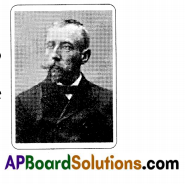
Roald Amundsen:
1. Roald Amundsen made a name for himself with his 1903-06 expedition on the Gjoa; he was the first to successfully navigate to North Pole and South Pole.
2. He wrote many books on his adventures.
3. In June of 1928 Amundsen disappeared when his plane crashed in the Arctic while on a rescue mission.
Sponsors of the expeditions: The governments, kings, and big traders sponsored the expeditions to improve trade relations with new countries.
Question 10.
Can you suggest how maps can be used to plan and set up new schools and colleges? What are the different kinds of maps would have to be studied for this? (Appreciation and Sensitivity)
Answer:
Maps help to know information about different routes to reach the school, surrounding areas, population, potentiality, water availability, soil suitability to construct pucca buildings etc. The types of maps to be studied are Physical maps, Population density map, Distribution maps, Climatic map, Contour map, Road map etc.
Question 11.
If someone wants to choose an appropriate place to set up a hospital what kind of maps would be useful to they? Make a list. (Information skills)
Answer:
Maps helpful for a person to set up a hospital are
- Physical map
- Climate map
- Population density map
- Transportation map
- Road/Street map
Question 12.
Why do you think maps are useful to armies in times of war? (Appreciation and Sensitivity)
Answer:
With the help of maps, armies can find out routes, the climatic conditions, the details of population, the safe zones, the important places of army posts, etc., to attack the enemy. Hence maps are very useful in times of war.
Text Book Page No. 13
Question 13.
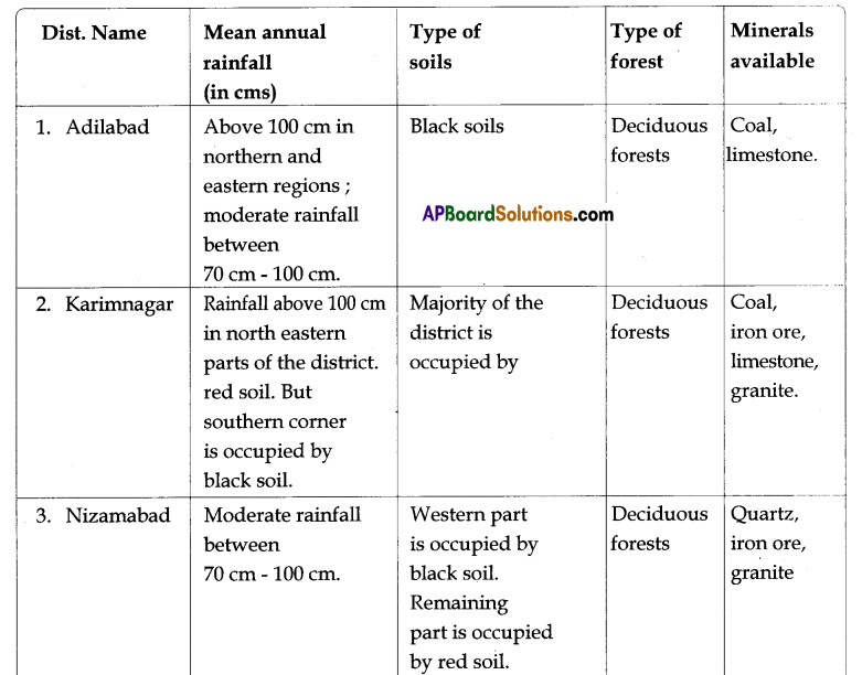
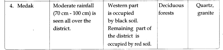
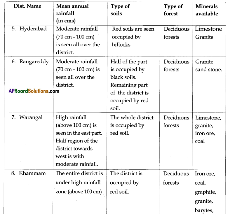
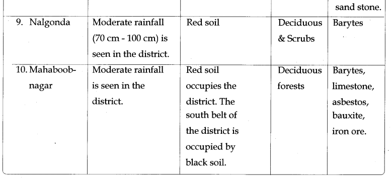
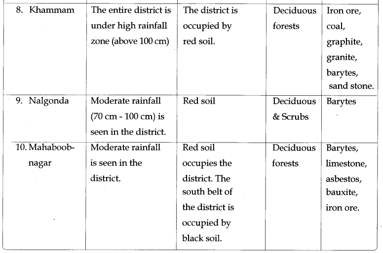
In this book there are different Thematic maps i.e. Relief and Drainage (Text page no.14), Mean Annual Rainfall (Text page no.15), Soils (Text page no.16), Forests (Text page no.55) and Minerals (Text page no.64). Now, make a table to identify the different information given for your district from the different types of maps mentioned above. (Information skills)
Answer:
Information on Mean annual rainfall, soils, forests and minerals in various districts in Andhra Pradesh.
(Note: Students can select the information given here under that suits their district.)
Additional Question
Question.
Choose two places of your choice from the Atlas and find out about them from at least five different thematic maps. Then compare the life in the two places – what would be similar and what would be different? (Information skills)
Answer:
This is a student activity. Here is an example.
| Thematic maps | India | Sri Lanka |
| Climate | Varies from tropical monsoon in south to temperate in north | Tropical monsoon; northeast monsoon (December to March); southwest monsoon (June to October) |
| Population | 1.37% in 2012 | 0.913% in 2012 |
| Agriculture | 4.5% in 2012 | 3% in 2012 |
| Literacy rate | 65-74% in 2012 | 92% in 2012 |
| Religion | Maximum Hindus, all religions exist | Maximum Buddhism followers, all religions exist |
Depending upon the above data, we understand that climate is almost similar in both the countries. The population and agricultural growth rates are more in India when compared to that of Sri Lanka. The literacy rate of Sri Lanka is higher than the literacy rate of India. All religions are found in both the countries.
![]()
Redding the Text (given), understanding and interpretation
Question 1.
Read the passage given below “When European powers ………………” and answer the following question.
“When European powers colonised the entire continents like North and South Americas, Africa, Australia, and Asia. They needed to know about the places, their climate, crops, mineral resources, and about the people living there “.
What were the factors responsible for establishment of colonies by European Nations?
Answer:
European nations purchased spices, cotton and silk cloth, Muslin, Indigo etc., from these colonies and when they sold these things in their countries they earned large profits. This gave impetus to trade, and to have full control over it, they established colonies in North and South America, Africa, Australia and Asia.
Question 2.
Read the passage given below” While map makers …………….” and answer the following question.
“While map makers usually use their own symbols, some symbols are used conventionally by most map makers. In India, we usually follow the conventions used by the survey of India.”
How do symbols help in reading maps?
Answer:
- With the use of symbols, maps are more informative and easier to read.
- The symbols are of the features in true form.
- Language do not put any problem in understanding the feature.
- Even the less educated can understand easily.
Mapping Skills
Question 1.
a) Map pointing & Map reading :
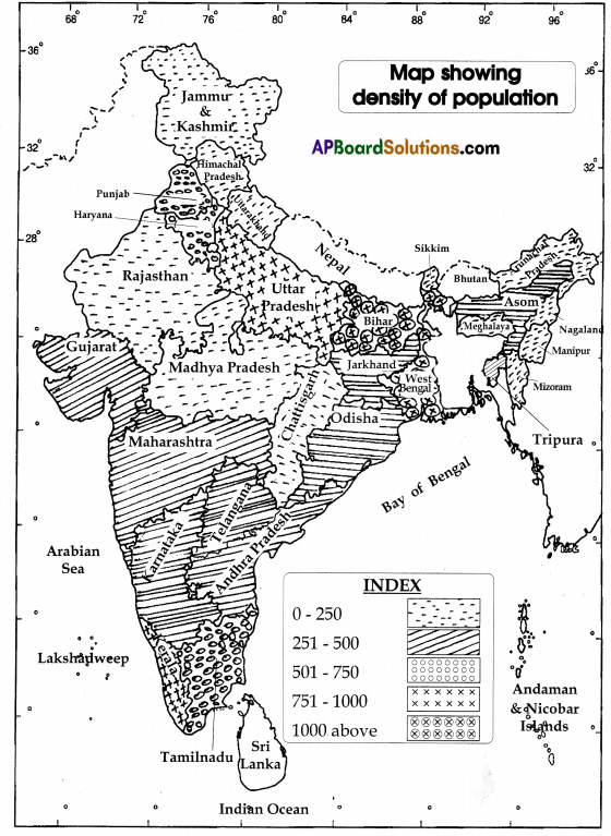
Draw a map showing density of population of India.
Answer:
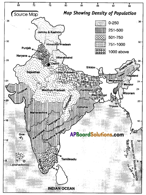
b) Map reading :
Look at the above map and answer the following questions.
1. What is the density of population of Kashmir?
Answer:
0-250.
2. Write a state where you find density ranging 751 -1000.
Answer:
Kerala.
3. Write any two states which have density of population ranging 1000 above.
Answer:
West Bengal, Bihar.
4. In Telangana, what is the density of population?
Answer:
250-500.
Question 2.
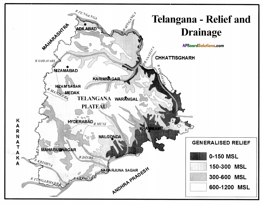
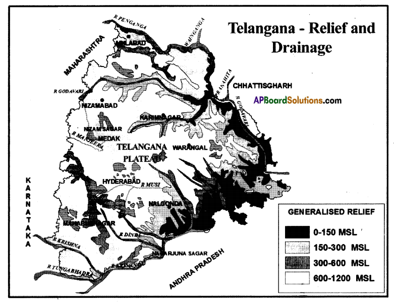
a) Map pointing: Draw the Relief and Drainage systems on the map given below.
Answer:
Question 3.
a) Map pointing: Draw the mean annual rainfall on the map given below.
Answer:
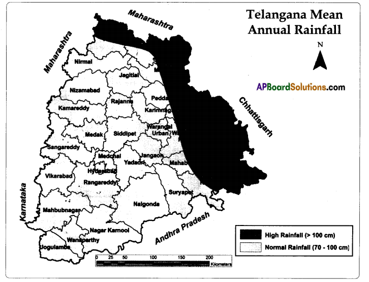
b) Map reading: Look at the map and answer the following questions.
1. Name the districts that receives high rainfall.
Answer:
Adilabad, Komaram Bheem, Manchirial, Jayashankar, Badradri, and partly Khammam, Mahabubnagar, Warangal.
![]()
2. Choose the correct answer.
i) Adilabad (b)
a) Scanty rainfall
b) High rainfall
c) Low rainfall
i) Mahaboobnagar ( a )
a) Normal rainfall
b) High rainfall
c) Low rainfall
3. When do you say an area has high rainfall?
Answer:
When it has rainfall above 100 cm.
4. With regard to rainfall, under what major category does Telangana come?
Answer:
Normal rainfall.
Question 4.
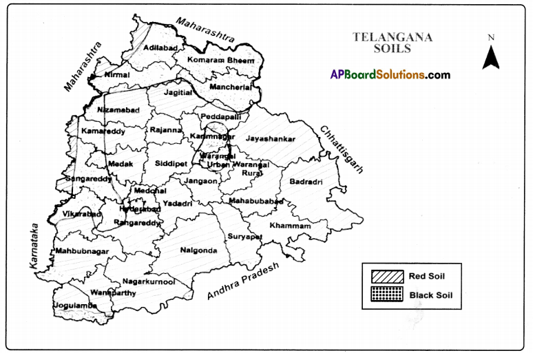
a) Map reading: Observe the following soils map and answer the following questions as follows.
Answer:
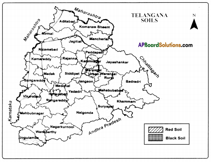
1. What types of soil do you find in Adilabad district maximum?
Answer:
Black soil.
2. What are the major soil types in Telangana?
Answer:
Black and Red soils.
3. What type of soil do you find in the Medak district?
Answer:
Mainly red soil and partly black soil.
4. What type of soil is found in Hyderabad?
Answer:
Mainly red soil and partly black soil.
Question 5.
Map Pointing:
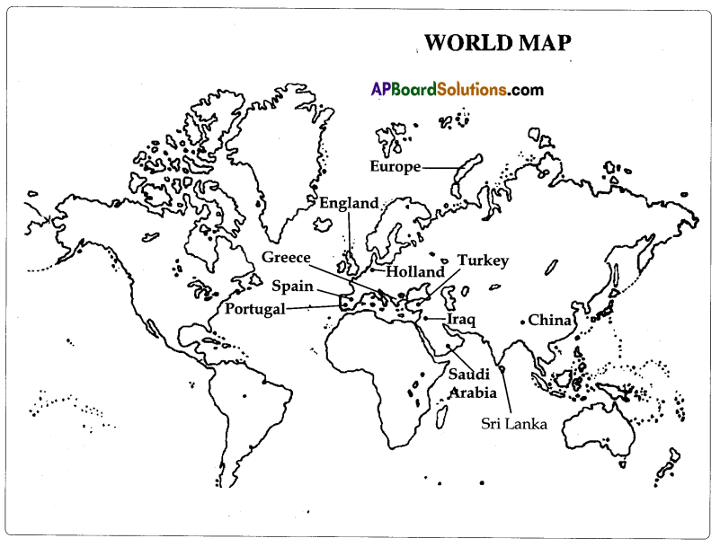
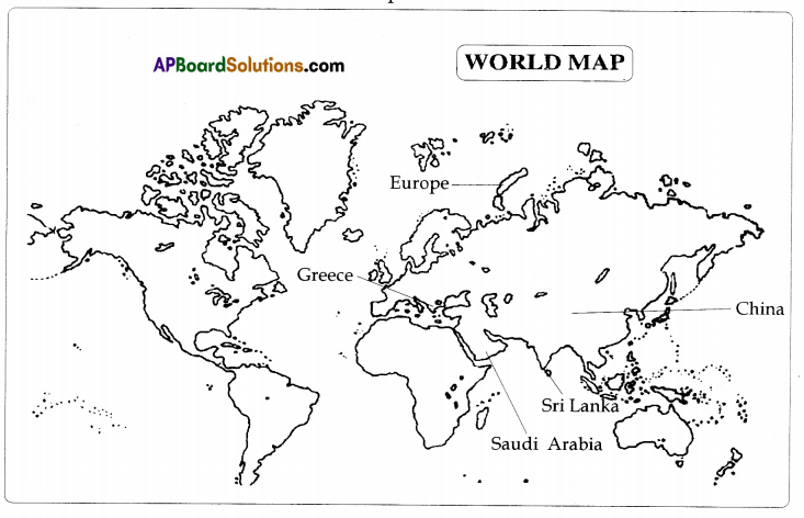
Mark the following places on World Map.
1. Greece
2. China
3. Europe
4. Sri Lanka
5. Saudi Arabia
Answer:
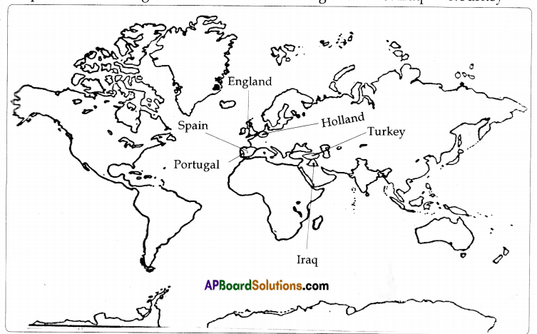
Question 6.
Map Pointing:
Locate the following countries in the given World Map.
1. Spain
2. Portugal
3. Holland
4. England
5. Iraq
6. Turkey
Answer:
Information Skills
Question 1.
Study the following table and answer the questions that follow.
| Topic | Definition |
| 1. Projection in a Map | As you know the world is like a ball, but when we draw it on paper we cannot show the curvature and have to show it as flat. This inevitably causes some distortion – either the shape of the continents and the distances will get distorted or things will get placed in wrong directions. Sailors needed correct directions and shapes so that they could identify the landmarks. Mercator devised a method for showing the correct shapes and directions of continents but with distortion of sizes and distances. This method (called Mercator’s projection) is still used to show the world. |
| 2. Representation of Relief feature on maps | Relief feature means the high and low places on the surface of the earth, the main relief features maps are hills, valleys, plateaus, plains, river basins, rocky and sandy places. Since the maps are flat we cannot show the heights on them. We, therefore, use a special symbol for this called contours or contour lines. Contours are lines on map joining places of same height measured from the sea level. In other words, all places on a contour line will have the same height from the sea level. Contour lines are also called isolines – lines joining places with some common features. |
1. Who devised a method for showing the correct shapes and directions of continents but with distortion of sizes and distances?
Answer:
Mercator.
2. What does Relief feature mean?
Answer:
Relief feature means the high and low places on the surface of the earth. The main relief features are hills, valleys, plateaus, plains, river basins, rocky and sandy places.
3. What are contours?
Answer:
Contours are lines on map joining places of same height measured from the sea level.
![]()
4. What is meant by Mercator’s projection?
Answer:
Mercator devised a method for showing the correct shapes and directions of continents but with distortion of sizes and distances. This method is known as Mercator’s projection.
II. Density of population year – 2011 (census – 2011)
| State | Density | State | Density | State | Density |
| Andhra Pradesh | 308 | Jammu & Kashmir | 56 | Nagaland | 119 |
| Arunachal Pradesh | 17 | Jharkhand | 414 | Odissa | 269 |
| Assom | 397 | Karnataka | 319 | Punjab | 550 |
| Bihar | 1102 | Kerala | 859 | Rajasthan | 201 |
| Chhattisgarh | 189 | Madhya Pradesh | 236 | Sikkim | 86 |
| Goa | 394 | Maharashtra | 365 | Tamilnadu | 555 |
| Telangana | 307 | ||||
| Gujarat | 308 | Manipur | 122 | Tripura | 350 |
| Haryana | 573 | Meghalaya | 132 | Uttarakhand | 189 |
| Himachal Pradesh | 123 | Mizoram | 52 | Uttar Pradesh | 828 |
| West Bengal | 1030 |
1. Which state has the highest density of population?
Answer:
Bihar.
2. Which state has lowest density of population?
Answer:
Arunachal Pradesh.
3. How many persons are living per square kilometer in Telangana?
Answer:
307.
4. Which states have equal density of population?
Answer:
Gujarat and Andhra Pradesh.
One mark Questions
Question 1.
Who were Sumerians?
Answer:
In olden days, the people of present-day Iraq were called as Sumerians.
Question 2.
What is the another name of Isoines?
Answer:
Contour lines are also known as Isolines.
Question 3.
Who was Alexander?
Answer:
Alexander was a Greek king who tried to conquer the whole world.
Question 4.
What was the birthplace of Jesus Christ?
Answer:
Jerusalem was the birthplace of Jesus Christ.
Question 5.
Write any two countries of western Europe?
Answer:
Spain, Portugal, and Holland.
Question 6.
Who was the father of Dutch Cartography?
Answer:
Gerardus Mercator.
Question 7.
Who began one of the most important geographical surveys in the world?
Answer:
William Lambton.
Question 8.
What is meant by density of population?
Answer:
Number of persons living per square kilometer is known as density of population.
Question 9.
What is the density of population of Andhra Pradesh as per 2011 Census?
Answer:
308.
Question 10.
What is an Atlas?
Answer:
An atlas is a collection of maps.
Objective Type Questions
Question 1.
What was the center of AI Idrisi’s map? ( )
A) Greece
B) Europe
C) Arabia
D) Africa
Answer:
D) Africa
Question 2.
Map projection was Invented by ( )
A) Al Idrisi
B) Gerardus Mercator
C) Ptolemy
D) Columbus
Answer:
B) Gerardus Mercator
Question 3.
![]() – This symbol shows ( )
– This symbol shows ( )
A) Church
B) Temple
C) Mosque
D) Gurudwar
Answer:
D) Gurudwar
Question 4.
What are also known as Isoflnes? ( )
A) Contours
B) Relief features
C) Plateaus
D) Boundaries
Answer:
B) Relief features
![]()
Question 5.
Anaximander was a ……………. geographer ( )
A) Greek
B) Roman
C) Italian
D) Dutch
Answer:
A) Greek
Question 6.
a) Columbus discovered America.
b) Vascodagama discovered sea route to India. Which one is true in these two statements. ( )
A) a only
B) b only
C) a and b
D) None of these
Answer:
C) a and b
Question 7.
………… map was prepared by. Da Ming Hun Yi Tu in 13S9 ( )
A) Cotton
B) Silk
C) Paper
D) Plastic
Answer:
B) Silk
Question 8.
‘Cartography means ……………….. . ( )
A) Science of technology
B) Science of human beings
C) Science of Oceanarium
D) Science of map making
Answer:
D) Science of map making
Question 9.
Arrange the following states in descending order as per population density of those states? ( )
i) West Bengal
ii) Bihar
iii) Uttar Pradesh
iv) Kerala
A) i, ii, iii, iv
B) iv, iii, ii, i
C) ii, iv, i, iii
D) ii, i, iv, iii
Answer:
D) ii, i, iv, iii
Question 10.
‘Mt Everest’ is the highest peak in this continent
A) Asia
B) Europe
C) Africa
D) South America
Answer:
A) Asia
Question 11.
Which one is correct in the following
i) Sumerians – Iran
ii) Babylonious – Iraq
iii) “Gerardus Mercator – Netherlands
iv) Modern maps – Satellite images
A) (i) and (ii)
B) (i) and (iii)
C) (iii) and (iv)
D) All of these
Answer:
D) All of these
Question 12.
Who was Al-Idrisi? ( )
A) Arab map maker
B) Cartographer
C) Both (a) and (b)
D) None of these
Answer:
B) Cartographer
Question 13.
Which is not a relief feature of the following? ( )
A) River basins
B) Rocky and sandy places
C) Districts
D) Plains
Answer:
B) Rocky and sandy places
![]()
Question 14.
Sumerians tried to keep records of ……………… with the help of maps ( )
A) villages
B) lands
C) minerals
D) houses
Answer:
B) lands
Question 15.
European mapmakers were greatly influenced by religious ideas of ……………. .( )
A) Quran
B) Bible
C) Gita
D) Adi-puran
Answer:
B) Bible
Question 16.
Contour lines means ………………. .( )
A) It is a line joining the places with equal heights
B) It is a line joining the places with equally recorded rainfall
C) It is a line joining the places with equally recorded pressure
D) It is a line joining the places with equally recorded salinity
Answer:
A) It is a line joining the places with equal heights
II. Map Pointing:
A) Locate the following countries in the given World Map.
1. Spain
2. Portugal
3. Holland
4. England
5. Iraq
6. Turkey
7. Greece
8. China
9. Europe
10. Sri Lanka
11. Saudi Arabia
Answer: