Telangana SCERT 10th Class Social Study Material Pdf Telangana 5th Lesson Indian Rivers and Water Resources Textbook Questions and Answers.
TS 10th Class Social 5th Lesson Questions and Answers – Indian Rivers and Water Resources
Question 1.
Draw a table to describe the major river systems in India with the following items:
direction of flow, countries or regions through which they pass, and relief features of the areas.
| Items | Major River Systems in India |
| Direction of flow | 1. The Indus -Flows from north to north-west 2. The Ganga – Flows from north to north-east 3. The Brahmaputra – Flows from North to north-east 4. The peninsular rivers except Narmada and Tapati – West to east 5.The Narmadas & Tapati-East to west |
| Countries or regions through which they pass through | 1. The Indus – Pakistan, Tibet (China), India 2. The Ganga – India, Bangladesh 3. The Brahmaputra – India, Tibet, Bangladesh 4. The Peninsular Rivers – India, Tibet (China), Bangladesh |
| Relief features of the areas | 1. The Himalayan Rivers: Mountains and plains 2. The Peninsular Rivers: Hills, Deccan Plateau, and plains. |
Question 2.
Identify and list arguments that would support or oppose the use of groundwater In various contexts such as agriculture, industry, etc.
Answer:
- Groundwater Is the major source of drinking water in both urban and rural India.
- It is also important source of water for the agricultural, Industrial, and other sectors.
The arguments that would support the usage of underground water are:
- These include higher productivity and its more equitable distribution among various classes of farmers, insurance against drought and stabilization of agricultural production, and enhanced employment generation.
- Underground water is both an important Input for manufacturing and industrial sectors
and used as coolant for machines. - Cheap water can be rapidly pumped from underground aquifers and it has been a major factor in the success of India’s economic growth.
The arguments that would oppose the usage of under groundwater:
- India is the world’s largest groundwater user in terms of both absolute volumes pumped and the total number of users.
- It led to declining groundwater levels and seawater intrusion in coastal areas.
- There is a continuous growth endark’ and ‘over-exploited’ areas m the country.
- Industrial waste is largely responsible for high level of pollutants found in groundwater.
Question 3.
Make a list of challenges faced In the water resources In the Tungabhadra basin. Identify the solutions that have been discussed In the context of these problems either In this chapter or elsewhere In different classes.
Answer:
The Tungabhadra river basin is one of the major sub-basin of the Krishna River basin in peninsular India.
Challenges faced In the water resources In the Tungabhadra basin:
1) Urbanization and water demands: Urbanization is a process by which a drainage district undergoes two major dangers, viz.
- Increase of population density and
- Increase of impervious area.
Such as residential, commercial and industrial along with other infrastructure developments which take place in watersheds inflict sometimes irreversible damages to natural flow regimes and the quality of water available.
2. Population growth leading to increasing pressures:
Population growth increases economic activity and improved standards of living lead to increased competition and conflicts over the limited freshwater resource.
3. Drinking water scenario in Tungabhadra basin:
Water is the prime need for human survival and also for industrial development. Both groundwater and surface water meet the drinking water requirements for various towns and villages across the basin.
Water Demands from Industrial sector in Tungabhadra Basin:
The Industrial sector is one of the major stakeholders of water consumption in the basin. 19 major industries are located on the bank of the river. A few more have come up in recent years and the demand on the water sector is quite increasing. The total consumption of industrial sector is 6.1 TMC ft.
Water and agricultural sector in Tungabhadra basin:
Approximately 80% of the poor live in rural areas of the basin and are dependent on agriculture for their livelihoods.
Land use cover and Land use change in Tungabliadra basin:
The land use change in the basin over a period is changed.
e.g: Forest area increased, and land available for non-cultivation is decreased.
Variations In cropping pattern: It is observed that canal irrigation is increased. Tanks irrigation has come down due to encroachment through irrigation, built-up areas, silt accumulation, and severe breaches of tank bed. Borewell irrigation is extended. Most of the area is used to cultivate cereals, pulses, and minor inlets and it is increasing annually. Non-food crops are also increased.
![]()
But cotton production and the areas have decreased a lot because of the pest affection, decrease In yield, and change in climate.
Unauthorized irrigation: A principle called localization was adopted in the project where only certain pockets within the command area were selected for irrigation leaving several patches unirrigated.
Impacts of climatic change: Temperature/Rainfall:
The 0.6° rise in average temperature and it leads to major evaporation loss n the basin. The rainfall varies from place to place. Evapotranspiration is also one of the major issues in the Tungabhadra basin.
Water conflicts between the states:
Water conflicts arise due to scarcity of water. But it is difficult to solve the conflicts because of the power politics in the states.
Solutions:
Integrated water resources management s a systematic process for the sustainable development allocation and monitoring of water resource use In the context of social economic and environmental and climate change. There should be coordination between different live departments in managing the water resources. An effective plan is required to envisage the transformation in the management of water. It is essential to put the principles of sustainable management policy into practice.
Question 4.
Which aspects of farming practices were regulated In the context of Hiware Bazar to Improve the water conservation?
Answer:
- Hiware Bazar Is situated on the eastern side of Sahyadri ranges In Ahmednagar district in Maharashtra.
- Continuous contour trenches were dug on the hl slopes to arrest the erosion of soil, water harvesting, and encourage growth of grass.
- There was ban on borrowed Is for irrigation, growing sugarcane, bananas, and selling one’s land to any outsider.
- The range of crops is diversified and potatoes onions, fruits, flowers, and wheat. etc. are practiced.
- The land was made much more productive as the water availability is increased and resulting in second crop during the year.
- The cult water of water-intensive crops like sugar was slopped.
- Water for irrigation should be taken only through dug wells
- Water use prioritization was taken up along with crop planning.
Question 5.
How significant are the laws and people’s actions, in the context of water resources? Write a short note based on the ideas discussed In the last two sections of the chapter.
Answer:
- The current laws about groundwater in many states are both outdated and inappropriate
- The basic link between access to groundwater and land ownership on which these rules are based are flawed. Landowners were not restricted in the amount of water they can take out.
- Water should be thought of as a collective pool resource that is meant for all people. Water is also public property. Registration is not easy.
- laws and rules are required to recognize that water Is a common flowing resource.
- Water resources require both collective action at the local level and appropriate laws and policies at the state and national levels.
Question 6.
in what ways Is water bought and sold in your area and for what purposes? Do you think there should be some checks and balances for this? Discuss.
Answer:
- The water in our area Is mainly supplied by our corporation. They supply through pumps Dallas. This water is used for drinking and household purpose.
- Drinking water is also supplied by some local companies after purification, They charge Rs. 15 to 30 for one refill.
Yes, I think that there should be some checks and balances for both these supplies. The corporation water tanks should be cleansed at regular intervals. The water should be purified through different possible methods. We should check the refills of the private companies also. And we should observe the cleaningffllteñng procedure at the point regularly.
Question 7.
Availability of water Is decreasing day by day. Ground water level is decreasing. How will It affect our lives, if this situation continues? Discuss the preventive measures and our responsibility.
Answer:
Statement: Cities and villages in India will soon run out of potable water if current trends Continue.”
“India’s groundwater tables are plunging at an alarming rate with reserves in some states dwindling to critical levels.”
Discussion:
Over 16% of the country’s groundwater resources are ‘over-exploiteð. Unregulated use has also led to over-extraction. Agriculture is the biggest consumer of groundwater accounting tot 91% of withdrawals
every year, while domestic and industrial withdrawals account for the remaining 9%. Weak monsoons due to climate change have further eroded indias groundwater reserves.
Solutions lie in Agriculture:
However, any solution to the country’s complex groundwater crisis will lie in tackling agricultural water use – IndIa’s thirstiest sector.
Preventive measures and our responsibility:
1. We don’t need the government to take care of these things. We can contribute our part in sustaining the natural resources of the environment.
2. We can introduce rainwater harvesting system in our societies which helps let water sleep underground, increasing groundwater levels.
3. Planting trees has unlimited benefits, including restoration of groundwater. We should plant as many trees around us as we can and also encourage careful maintenance of garden areas in our society.
4. Awareness is the first step towards change. It is equally important to spread this information around to as many people as we can. Emphasis should be given to development that doesn’t pose a threat to our natural resources. Together, we have to vow to save the environment.
Project
Question 1.
Think of plans for your village or locality, which if implemented would help everyone.
Answer:
Self Activity.
![]()
TS 10th Class Social 5th Lesson Indian Rivers and Water Resources Intext Questions
Page No. 59
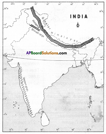
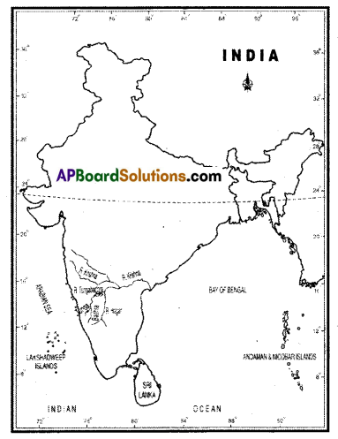
Question 1.
On a map of India identify and mark the Himalayas and the Western Ghats.
Answer:
Question 2.
Using the colour code, Identify the height range in which some of the rivers originate. Using the flash and the raised relief map, 10110w the course of these rivers and locate the direction in which they are flowing.
Answer:
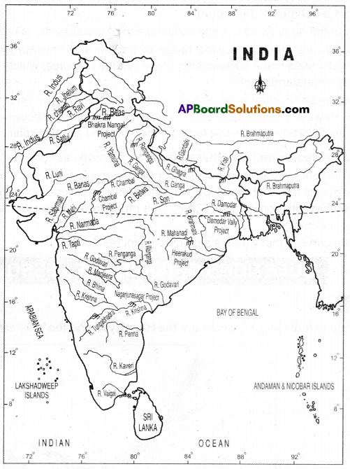
| Name of the river | Source | Elevation | Direction |
| The Indus | Sengge zangbo; Tibet | The average elevation of Tibet is 4500 meters | North to Northwest |
| The Ganga | Gangotri glacier | 3,892 meters | North to North – East |
| The Brahmaputra | Chemayungdung glacier | 5,210 meters | North to North – East |
| The Mahandi | Siwaha. Chhattisgarh | 890 meters | West to East |
| The Godavari | Brahmagiri Triarnbak, Nasik | 920 meters | West to East |
| The Krishna | Mahabaleshwar | 1,337 meters | West to East |
| The Cauveri | Tala Cauveri Western Ghats | 1,276 meters | West to East |
Question 3.
Discuss: About 5% of the total water on the Earth is used for domestic purposes and yet a large section of the population does not have access to the water.
Answer:
- Water supply is a state responsibility under the Indian Constitution.
- A number of innovative approaches to improve water supply have been tested India. e.g.: Demand-driven approaches in rural water supply.
- Depleting groundwater table and deteriorating groundwater quality are threatening the
sustainability of both rural and urban water supply in many parts of India. - The supply of cities that depend on surface water is threatened by pollution. Increasing water scarcity and conflicts among users.
- In some coastal areas, seawater desalination is becoming an important source of drinking water supply.
- Water touches every aspect of life and in India, uncertainty over access to and the availability of this basic resource may be reaching crisis levels due to population growth, growth in industrial sector, etc.
- There is a need to river linking in India.
Question 4.
40 million hectares of land in India is flood-prone and an equally large part of the country is also drought-prone. What are the causes of this?
Answer:
- In India major rainfall is received from southwest monsoon in the summer season.
- The vagaries of this monsoon are main cause of floods/droughts in our country.
- Floods are associated with excessive rainfall while the droughts are the result of deficit rainfall.
- Hydrology, deforestation, soil nature, and erosion also play an important role in these calamities.
Question 5.
70% of our surface water resources are polluted. Why?
Answer:
Water bodies get contaminated due to the discharge of pollutants in the water bodies without any treatment to remove harmful compounds. Water pollution adversely affects not only aquatic plants and animals but it also affects human beings and ecosystems.
Causes of water pollution :
- Sewage and wastewater: Sewage, garbage, and liquid waste of households. agriculture lands and factories are discharged into lakes and rivers. These wastes contain harmful chemicals and toxins which makes the water poisonous for aquatic animals and plants.
- Dumping: Dumping of solid wastes and litters in water bodies causes huge problems. Different things take different times to degrade in water.
- Industrial waste: Industrial waste is discharged into lakes and rivers by using fresh water making the water contaminated.
- Oil pollution: Sea water gets polluted duelo oil spilled from ships and tankers while traveling.
- Acid rain: Acid rain is rain that contains large amounts of harmful chemicals from factory gases and that damages trees, crops, and buildings.
- Global warming: A gradual increase in world temperatures caused by polluting gases such as carbon dioxide which are collecting in the air around the earth that results in death of aquatic plants and animals.
- Eutrophication: Eutrophication is an increased level of nutrients in water bodies. This results In bloom of algae in water and depletes the oxygen in the water, which negatively affects fish and other aquatic animal populations.
![]()
Page No. 60
Question 6.
With the help of an atlas trace the course of Indus both in India and Pakistan.
Answer:
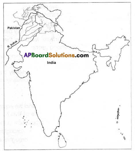
Out of the total length of 2880 kms, Indus flows 709 kms through Jammu and Kashmir in India and 2171 kms in Pakistan.
Question 7.
Look at the map of river Ganga and name the states which are drained by it.
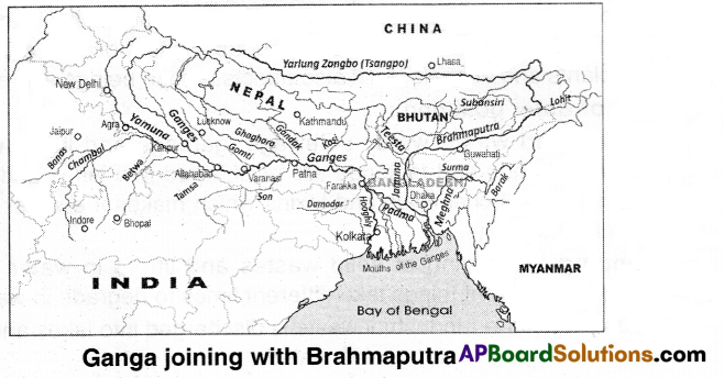
Answer:
The following states are drained by the river Ganga:
- Uttarakhand
- Uttar Pradesh
- Bihar
- Jharkhand
- West Bengal
Question 8.
The above map list out the north-flowing and south-flowing tributaries of the Ganga.
Answer:
The north-flowing tributaries: The Kosi. the Gandak, the Ghaghra, the Gornati, the Sarda, the Vamuna, the Teesta rivers.
The south-flowing tributaries: The Son, the Rihand, the Ken, the Betwa, and the Tansa. the Chambal, the Sind rivers.
Page No. 61
Question 9.
From the Map and using your atlas, describe the following:
a) The Godavari originates in at …………………… .
b) The Krishna is the second largest east-flowing peninsular river which rises near …………… .
c) The Mahanadi rises near Sihawa in Chhattisgarh and runs through ……………….. .
d) The Narmada originates near ………………….. in Madhya Pradesh.
e) The Tapati originals from ………………… and flows …………………………… (fill in the direction 01 flow)
Answer:
a) Tnambakam
b) Mahabaleshwar
c) Odisha
d) Amarkantak
e) Multal; westward
Page No. 62
Question 10.
Discuss the term watershed.
Answer:
- Watersfled is a line of high land where streams on one side flow into one river and streams on the other side flow into a different river.
- If the water(rainwater) were to be checked by vegetation or bunds, then there would be a greater possibility of the water percolating into the soil to join the groundwater.
- Over the last few years, great efforts have been undertaken to harvest rainwater by these means.
- These measures are usually taken for a stream or a flyer.
- Such efforts are called Watershed development projects.
- Under these projects trees and grasses are planted on the hill slopes from where a stream starts and small bunds are built across streams to stop the flow of water.
Question 11.
From the nearest Mandai office, find out the total annual rainfall for your area over the past 5 years.
Answer:
Students
Activity.
Page No.64
Question 12.
On a map of India, trace the course of Tungabhedra river.
Answer:
Page No. 66
Question 13.
How would It help if there was a government river basin authority for overall planning of water use?
Answer:
- It would do justice to a users of river basins water.
- It would develop and manage the water resource at all the levels. e.g.: local and micro levels.
- It would involve the community organizations In the authority.
- It would reduce the growing conflicts and the possibility of social unrest in the country In future due to water scarcity.
- It would rejuvenate the traditional techniques in conservation and management, recognition of water as a common property resource.
Question 14.
What are the different conflicts in the use of water for Tungabhadra river basin?
Answer:
Different conflicts In the use of water for Tungabhadra river basin:
The reservoir water storage capacity of the Tungabhacka reservoir is reducing due to siltation from mining activities, dust, soil erosion, etc.
Conflicts within and across sectors are common apart from Interstate disputes. Population pressure and increased urbanization have added on. With issues being complex at various levels, the impacts have been serious resulting in land use changes. pollution and groundwater contamination affecting quality of life and livelihoods of vulnerable communities.
Page No. 68
Question 15.
Underline sentences and make a list of steps that reflect the efforts taken for water conservation in Hiware Bazar.
Answer:
- Most significant was the ban on borewells for irrigation, growing sugarcane and banana, and selling one land to any outsider.
- The most significant development is that increased water availability has made a second crop possible due to normal rainfall.
- Social control over groundwater extraction and use no borewells for irrigation only for drinking water) no water-intense crops like sugarcane.
- Water for irrigation should be taken only through dug wells.
- They keep rainfall data meticulously and use it for crop planning and water use prioritization.
- As they plan according to water available there was no shortage of water to drink even in years of continuous drought.
Question 16.
What was the effort for planning agriculture according to the available water?
Answer:
- In countries like India, agriculture typically conserves over 70% of the water supplies. Agricultural practices often lead to overconsumption of water.
- Trenches, dams, and catchments can help farmers use water efficiently and can also help improve crop yields.
- Conserving water through drip irrigation and sprinklers can help to ensure that farmers use water more efficiently.
Question 17.
If you have access to Internet, watch a documentary about Hiware Bazar at http:// blt.lylkothL1.
Answer:
Self Activity.
Page No. 70
Question 18.
Should groundwater regulation be primarily community-led, as in the case of Hiware Bazar?
Answer:
Hiware Bazar is a village that has achieved success through investing m local ecologies for economic good. The village followed an ¡ntegrated model of development with water conservation as its core, It won the national water award for its efforts in water conservation and raising village productivity levels. So the groundwater regulation should be primarily community-led, as wi the case of Hiware Bazar.
Question 19.
The groundwater laws are both outdated and inappropriate.” Explain.
Answer:
Groundwater has become the main source of water for all the main uses of water, This tremendous increase has significant impacts on water availability and on access to water. The current regulatory regime is in large part still based on principles inherited from the colonial period. These are both outdated and inappropriate.
They are outdated because they were developed at a time when groundwater was a marginal source of water and when humans were not able to affect the level of the groundwater table through their use which was largely limited to drawing water from wells.
They are inappropriate because the basic nexus between access to groundwater and land ownership cry which these rules are based makes common law rules socially inequitable and environmentally unsustainable.
![]()
Question 20.
Should groundwater be considered e common pool resource? Explain your view.
Answer:
The groundwater cri&s is acquiring alarming proportions in many parts of the country. Overuse and deteriorating water quality must be based on a new approach involving typologies the resource problems and redefining the institutional structure governing groundwater. This approach Is based on the notion of groundwater as a common pool resource. So groundwater should be considered a common pool resource.