Telangana SCERT 10th Class Social Study Material Pdf Telangana 4th Lesson Climate of India Textbook Questions and Answers.
TS 10th Class Social 4th Lesson Questions and Answers – Climate of India
Question 1.
Read the following statements and find out they are an example of weather oc climate.
(a) During the last few years, many glaciers have melted in the Himalayas.
(b) During the last few decades, drought in Vidarbaha region has increased.
Answer:
a) It is an example of weather.
b) It is an example of climate.
Question 2.
Describe India’s climate controls.
Answer:
The factors that affect climate are called climatic controls, These include
- Latitude
- Land – water relationship
- Relief
- Upper air circulation
1) Latitude:
In India, the southern part has n the tropical belt closer to the equator. Therefore this region has higher average temperature than the northern part. This is the reason for the climate of Kanyakumari being entirely different from Bhopal or Delhi. India is situated roughly between 8° and 370 N latitudes and the country is divided into almost two equal parts by the Tropic of Cancer. The part south of the Tropic of Cancer lies in the tropical zone. The part north of the Tropic of Cancer lies in the temperate zone.
2) Land-water relationship:
A large part of southern India. because of its long coastline, comes under the moderating influence of the sea. As such, the difference between the temperature of day and night a that of summer and winter is not much. This is known as equable climate. If we compare similar places on the same latitude and altitude, we can appreciate the effect of the sea.
3) Relief:
Several hilt stations of the Himalayan region like Shimla. Gulmarg, Nainital and Darjeeling have a cool climate oven during the peak summer months. Similarly, Kodaikanal and Udagamandalam (Ooty) have cooler climates, compared to places near the coast.
4) Upper atmospheric circulation:
The climate of India Is also affected by the movement of upper air currents known as ‘jet streams’. These are fast-flowing air currents in a narrow belt in the upper atmosphere, above 12,000 m. The speed varies from about 110 kn’Vh In summer to about 184 km/h in winter. An easterly jet stream develops at about 25°N. A Jet stream causes the neighbouring atmosphere to cool. This coding effect of the easterly jet stream causes
ram from clouds already found over this latitude (25°N).
![]()
Question 3.
Write a short note on factors Influencing climatic variations in hilly areas and deserts.
Answer:
The factors in climatic variations in hilly areas:
Normally, climatic conditions become colder as altitude increases. At higher altitudes. the temperature drops. Specifically, temperature goes down 6°C for every 1000 metres of ascent. This happens because air pressure decreases, allowing the air to expand and get colder. Cooler temperatures translate to less evaporation and more moisture in the air, which is why high elevations often have a lot of snowfall, High lands sometimes prevent air from moving to other low areas, meaning that the transport of water Is also limited. This
can result in a very dry or desert-like climate in the lower regions.
The factors In climatic variations in deserts:
Desert areas are generally low n precipitation and in relative humidity and high in temperature. The areas are associated mainly with divergent air flows at low altitudes, with atmospheric subsidence and stability. Relief of the desert plays a crucial role in its temperature being decided and the inland nature shuns any influence at the land-water relationship. The rainfalls in these regions are scanty and diurnal temperature range Is very high.
Question 4.
How are human activities contributing to global warming?
Answer:
Human activities contribute to ornate change by causing changes in Earth’s atmosphere in the amounts of greenhouse gases, aerosols and cloudiness. The largest known contribution comes from the burning of fossil fuels, which releases carbon dioxide gas to the atmosphere.
Greenhouse gases and aerosols affect climate by altering incoming solar radiation and outgoing infrared radiation that are part of Earth’s energy balance Changing their atmospheric abundance or properties of these gases and particles can lead to a warming or cooling of the climate system.
Since the start of the industrial era (about 1750), the overall effect of human activities on climate has been a warming influence. The human impact on climate during this era greatly exceeds that due to known changes in natural processes such as solar changes and volcanic eruptions.
Question 5.
What are the disagreements between ‘developed’ and developing’ countrIes about AGW?
Answer:
There are disagreements between the developed countries (mainly industrialized, economically more advanced counties of the West) and ‘developing’ countries (countries that are not as industrialised) about AGW (Anthropogenic Global Warming). Developed countries want developing countries to cut down on burning coal and other activities that add greenhouse gases to the atmosphere. Developing countries argue that developed countries developed precisely by burning fossil fuels in their development.
Developing countries say that their economic development will be seriously damaged If they don’t burn fossil fuels (mainly coal), and that developed countries should do their fair share of work to help find alternatives that can help the developing countries to progress.
![]()
Question 8.
How is climate change causing global warming? Suggest measures to minimise the influence of the global warming.
Answer:
- Now heating of earth is much more rapid and could lead to catastrophic changes.
- Much of the warming has been occurring since the Industrial Revolution,
- Volumes of methane under the frozen tundras of northern latitudes is discovered,
- As global temperature increases, the ice in the tundra melts more,
- The methane trapped in, the ice escapes into the atmosphere increasing global temperatures.
- In turn, this causes even more ice to melt, releasing more methane, and so on.
- To minimize the influence of the global warming, we should plan to reduce the emissions
of greenhouse gases like CO2, Methane, etc. - We should take up afforestation.
- We should encourage public transport.
- We should minimize the use of refrigerators and air conditioners, etc.
Question 7.
Observe the following climograph and answer the following questions.
A) Which month received the highest rainfall?
B) Which months experience the highest and the lowest temperature?
C) Why does the maximum amount of rainfall happen between June and October?
D) Why Is the temperature high between March and May?
E) Identify relief conditions causing variation in temperature and rainfall.
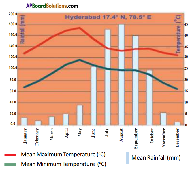
Answer:
A) ‘August’ month received the highest rainfall.
B) The highest temperature is experienced in the month of May. The lowest temperature is experienced in the month of December.
C) The maximum amount of rainfall Is received n Hyderabad between the months of June
and October, The reason for this is the presence of southwest monsoons.
D) The temperature is high between March and May because it is summer season.
E) Hyderabad is located in the Deccan Plateau. It is situated at an elevation of 600m from
the mean sea level.
Question 8.
Read the 4th para of page 54, i.e. “Earlier cycles of ……………………….. because of human
activities” and comment on it.
Earlier, cycles of cooling and warming happened over very long periods of time. This allowed most of the life on Earth the time to adapt to the changes. The problem now is that the healing is much more rapid and could lead to Cala strophic changes. Much of the warming that has been occurring since the Industrial Revolution is because of human activities.
Answer:
The issue discussed in this paragraph is that the industrial revolution causes for many changes related to the atmosphere. Warming is increased over the period. Human activities are the reasons for these changes.
Healing is gradually increasing because of human activities like using of vehicles, plastic, refrigerators, cell phones, and releasing of industrial effluents. Deforestation is also one of the major reasons. The trees are helpful in maintaining the weather cool. More and more greenhouse gases are released due to industrialization. In a way, the increase in industrialization is useful in making the lite easy but t created much damage to the atmosphere. Improvement of Industries is acceptable but everyone should think of future.
Development and modernization should not become the hurdle to the human life. Though there is a development of industries it should not affect the life of future generations. If it is done in this way it is not sustainable development. The pollution and damage to the nature affects the human life. So human beings should think of their activities keeping the future in mind.
Project
Question 1.
Collect the local proverbs/ sayings related to climate and weather in your region.
1. A Rainbow in the morning is the Sailor’s Warning.
2. A Rainbow at night is the Sailor’s delight.
3. When the dew is on the grass, rain will never come to pass.
Answer:
“Red sky at night, sailor’s delight. Red sky in the morning, sailor take warning.”
“Mare’s tails and mackerel scales make tall ships take in their sails.”
“Clear moon, frost soon.”
“Halo around the sun or moon, rain or snow soon.”
“Rainbow in the morning gives you fair warning.”
“When the stars begin to huddle, the earth will soon become a puddle.”
Question 2.
Both the developed and developing countries are releasing Green house gases into atmosphere. As a result, many disasters are happening. Collect information, pictures and discuss, on its severe consequences in classroom.
Answer:
The anthropogenic component of the greenhouse effect is caused by man’s activities that emit greenhouse gases to the atmosphere. The most important of these is the burning of fossil fuels. Changes in land use are also important sources of greenhouse gas emissions. For example, deforestation results in the emission of carbon dioxide to the atmosphere that was previously stored on the Earth’s surface in the form of trees and other vegetation, or locked up in soils.
We emit carbon dioxide to the atmosphere in enormous quantities because we burn so much fossil fuel and the changes in land use that we have implemented are so widespread. This ¡s why carbon dioxide is the most important gas in the man-made component of the greenhouse effect.
TS 10th Class Social 4th Lesson Climate of India Intext Questions
Page No. 45
Question 1.
Collect some more similar newspaper reports. (Project Work)
Are these indicators of some change or just a variation that happens once in a long time? Invite some meteorological officials or college faculty to discuss these developments.
Answer:
Self Activity.
Page No. 46
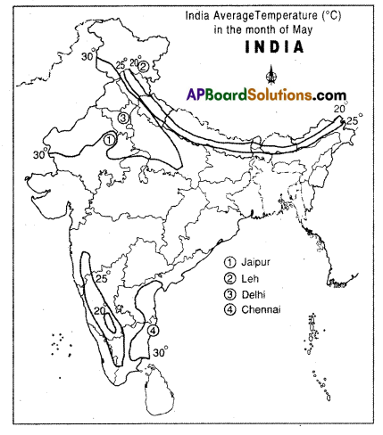
Question 2.
Fill the table after reading the climographs.
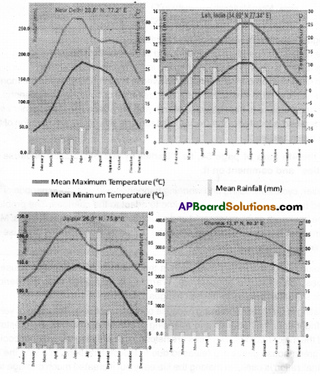
| Place | Relief region | Range of Range of minimum during the year | Range of minimum temperature during the year | Name the wettest month and the rainfall (mm) for that month | Name the driest month and the rainfall (mm) for that month |
| Jaipur | |||||
| Leh | |||||
| New Delhi | |||||
| Chennai |
Range of Temperature: From ghost value to lowest value
Answer:
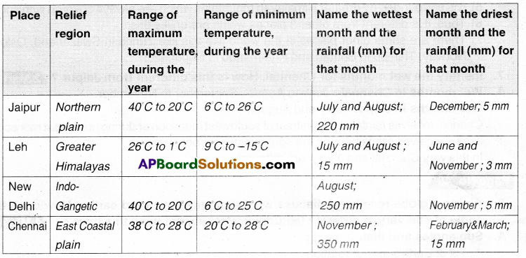
![]()
Question 3.
What are the warmest and coldest months in Leh?
Answer:
The warmest month in Leh is: June
The coldest month, in Leh, is: January.
Question 4.
From the range of temperatures in the above table, say whether Jaipur is, In general, hotter than Leh. Explain your answer.
Answer:
Jaipur is hotter than Lob.
Reasons:
- Leh is located at a high elevation when compared to Jaipur.
- Jaipur’s climate is influenced by the Thar Desert.
Question 5.
Compare the climate of Delhi and Chennai. How are they different?
Answer:
The climate of Delhi is a monsoon-influenced humid subtropical with high variation between survivor and winter temperatures and precipitation. Its climate‘s greatly influenced by its proximity to the Himalayas and the Thar Desert causing it to experience both weather extremes.
Climate of Chennai: The geographical location determines the weather and climate in Chennai. The dose proximity and the thermal equator makes the climate and weather in Chennai relatively consistent with less variation r the seasonal temperatures. The weather in Chennai is mostly hot and humid. Delhi and Chennai are both different in their geographical locations.
Question 6.
Read carefully the rainfall pattern for Leh. In what ways Is this different from the others? From your atlas, can you find out some other places in the world that have similar rainfall pattern.
Answer:
- Leh is situated nearly 6 kms above the mean sea level.
- So the atmosphere there is not conducive to rain.
- It receives less than 10 mm as the maximum monthly rainfall.
- The repairing three places receive 200 mentors more rainfall as the maximum monthly rainfall.
- It is surrounded by greater Himalayan mountains which are always covered with snow.
- Thus, it is coherent from other 3 places which are unlike this.
- There are some other places in the world like this like Zurich in Switzerland, and Oslo in Norway. Thimpu in Bhutan and Khatmandu In Nepal. etc.
Question 7.
Identify the wet months for Chennai. How is this different from Jaipur?
Answer:
- Wet months in Chennai: June to August, September to November.
- Wet months in Jalpur: July and August.
- Cherwiai receives rainfall during the retreat of the southwest monsoon or &ring north-east monsoon.
- Jaipur receives rainfall during the southwest monsoon. In this way Chennai and Jaipur are different.
Page No. 48
Question 8.
Using a globe recall end discuss what you may have read earlier. How does the angle of sun vary at different latItudes? What Impact does this have?
Answer:
Sun angles and their Impact:
A tilt of Earth’s axis of rotation.
- Axis of rotation tilted 23.5° away from perpendicular to plane of earth’s orbit.
- Axis points same direction as Earth orbits the Sun.
Creates seasonal variations in which hemisphere is oriented toward Sun.
- Solastices – Summer hemisphere pointed toward incoming solar beam.
- Spring and Fall equinoxes – equator pointed toward incoming solar beam.
The latitude where Sun is directly overhead at Solar noon:
- Ranges from 23.5°N on June 21 t0 23.5°S on June21 to 23.5°S on Dec. 21
- Solar zenith angle Angie of sun away from vertical 90° – sun angle (angle above horizon)
- Solar noon zenith angle Latitude – Solar declination (negative for Southern hemisphere)
Highest point in sky sun reaches on a given day. Santha Barbara’s latitude is 35°N
June 21 solar noon zenith angle:
35-23.5 = 11.5e (Sun angle – 78.5°)
Dec. 21 solar noon zenith angle : 35- (-23.5) = 58.5° (Sun angle – 31.5°)
Page No. 49
Question 9.
Find out the temperatures of Mumbai and Nagpur for winter and summer months and
compare them. How are they similar or different? How does it explain the distance from the sea?
Answer:
Average temperatures of Mumbai and Nagpur
| Mumbai | Nagpur | |
| Jan | 24°C | 21°C |
| Feb | 25°C | 23°C |
| Mar | 27°C | 28°C |
| Apr | 29°C | 33°C |
| May | 31°C | 35°C |
| June | 29°C | 32°C |
| July | 28°C | 30°C |
| Aug | 23°C | 30°C |
| Sep | 28°C | 32°C |
| Oct | 29°C | 32°C |
| Nov | 28°C | 30°C |
| Dec | 26°C | 28°C |
There are variations in both the temperatures throughout the year, The monthly averages of a place are almost equal throughout the year. This explains of the distance from the sea.
Question 10.
With the help of the climograph. can you explain the differences In temperature for Jaipur and Chennai?
Answer:
Differences:
| Jaipur | Chennai |
| 1. Jaipur is far away from sea coast | 1. Chennai is on the sea coast. |
| 2. The influence of the Thar Desert is on Jaipur | 2. Chennai has no influence of any desert. |
Question 11.
Are Shimla and Delhi located on very different latitudes? Check with your atlas. Is ShimIa cooler than Delhi during summer?
Answer:
Shimla is located on 31°6’ 1. Northern latitude.
Delhi is located on 28° 38 North latitude.
Yes, Shimla and Delhi are located on different latitudes. (3° difference) But Shln’a is cooler than Delhi during summer because it is located on higher altitude.
![]()
Question 12.
Why does Darjeellng have pleasant weather as compared to Kolkata during summer season?
Answer:
Darjeeling is at an elevation of 2,645 meters. Kolkata is at an elevation of 016 meters. Even though both are located in West Bengal. there Is a difference in their elevations. So, Darjeeling has pleasant weather when compared to Kolkata.
Page No. 50
Question 13.
What would be the range for average temperature In Telangana for January?
Answer:
- January is the month during which winter is severe.
- It usually will be cold during this month throughout Telangana.
- For the month of January, the average maximum temperature is around 28°C.
- The average minimum temperature is around 16°C for January in Telangana. .
- Thus range of average temperature for January in Telangana is around 28°C to 16°C.
Question 14.
Using your atlas, find some places located on 15°C temperature.
Answer:
The places that are located on 15°C are Jaipur, Mathura, and Itanagar. etc.
Question 15.
Close to the line showing places where average temperature is 25°C, there’s a small circle of places on 20°C. How is this possible?
Answer:
- Close to the knee showing places where average temperature is 25°C, there is a small circle of places on 20°C.
- That is the region where the Western Ghats rise above 2000 m peaks.
- There are the Nilgiri Hills which has peaks more than 2000 mt. height.
- So the temperatures there are less as the elevation is more.
- That is wily there was 20°C circle close to 25°C Iine.
Page No. 51
Question 16.
From the climograph given, (Graph 1.4, See Q.No.: 2), note the approximate average temperature for May for the four places and mark them on the given map.
Answer:
- Jaipur 24°C to 40°C
- Leh 3°C to 15°C
- New Delhi 34°C to 40°C
- Chenriai 27°C to 37°C
Page No. 55
Question 17.
What is deforestation?
Answer:
- Cutting down of the trees indiscriminately in the areas of forest or where there a presence of sizable number of trees like plantations is called deforestation.
- It results in the lowering of the green cover.
- It affects the ecological balance.
Question 18.
Does deforestation happen only In forest areas? How about in your local area, even if there are no forests?
Answer:
No. Deforestation happens not only in forest areas but also in industrial towns, mining areas, and cities.
Forest has been of great importance to mankind since prehistoric days. 60% of the earth was once covered with forest. With the development of civilization, large areas have been cleared to make way for farms, rivers, towns, and roads. It would be too hot without forests.
We would have no oxygen. Rain will make more floods as there are no trees to absorb. Trees absorb greenhouse gases and entwist. They produce oxygen and perpetuate the water cycle. There will be no such works.
Question 19.
How does deforestation affect global warming?
Answer:
- Forests through photosynthesis absorb carbon dioxide (CO2) and release oxygen (O2).
- The limber of the trees also sequesters carbon.
- Deforestation means the timber may be used and eventually converted to carbon dioxide or left to rot, which also means that ills converted to CO2, a greenhouse gas responsible for global warming.
- Sirrwlarty the green leaves no longer act as carbon sinks to suck in CO2.
- Either way, deforestation contributes to the global warming process.
- Deforestation = Fewer trees = More CO2 = Enhanced greenhouse effect = Global warning.
Question 20.
What are some other ways in which human activity contributes to global warming?
Answer:
- Usage of refrigerators and air conditioners, etc. by humans leads to global warming.
- Usage of motor vehicles which run on fuel emits greenhouse gases.
- Usage of inorganic fertilizers. chemicals and pesticides.
- Releasing of effluences and wastes of industries.
- Excessive usage of natural resources.
- Burning foss fuels.
- Clear-cutting forests.
![]()
Page No. 56
Question 21.
Imagine how one would cope with the situation If millions of people were affected. Where would you find land for resettlement? What lobs would they do?
Answer:
- If millions of people were affected with any natural calamity, it certainly would be difficult to cope with.
- The government has to make arrangements to resettlement of all those affected.
- It may seek help from international organisations or non-governmental organizations in our country as well as the donors.
- It will be a Herculean task to provide them shelter and alternate employment, but government must take initiative to get it done.
- It must enjoy the eligible to work within Rural Works Programme. Food for Work, Mahatma Gandhi National Rural Labour Employment Guarantee schemes, etc.