Telangana SCERT TS 6th Class Social Study Material Pdf 2nd Lesson Globe – A Model of the Earth Textbook Questions and Answers.
TS 6th Class Social 2nd Lesson Questions and Answers – Globe – A Model of the Earth
Improve Your Learning
Question 1.
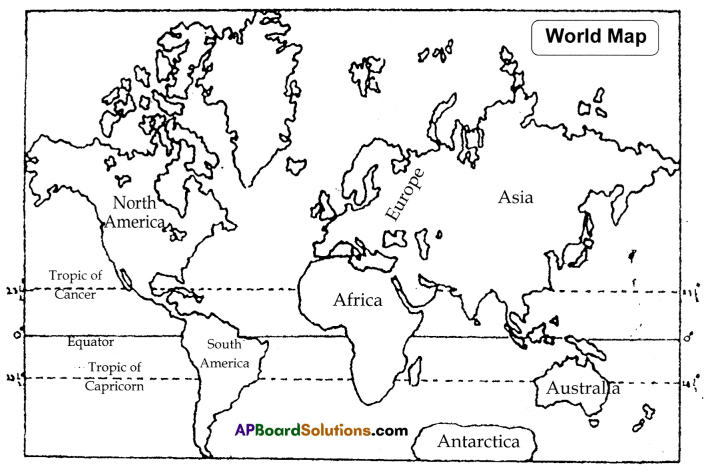
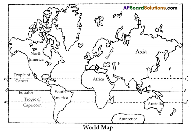
There is an outline map of the world. Identify and write the names of the continents
and the oceans. Then colour the map using appropriate colours. Write the names of the main latitudes. (Mapping Skills)
Answer:
Question 2.
Ramesh says “Earth is flat”. What do you say? (Conceptual understanding)
Answer:
Ramesh says’ “Earth is flat” thinking like the people who believed some four hundred years ago that the Earth was flat and that if anyone kept travelling in any direction, he would reach the edge of the Earth and from there he would fall off into the sky.
Some explorers of Europe set out on sea and knew that the Earth was not flat. Now we can say the Earth is like a ball – spherical in shape. The interesting thing about the shape of the Earth is that h’ travelling from one point in one direction we come to the same point without turning hack. So, will say strongly that the Earth is like a ball round. The photos taken from artificial satellites proved that the Earth is round.
Question 3.
“Rosy is spinning a bangle like a top” – What shape do you see? (Conceptual understanding)
Answer:
When Rosy is turning a bangle like a top, it looks like a globe turning round on its axis with speed.
Question 4.
Collect information about explorers like Columbus. (Information skills)
Answer:
Around 1400 AD, scientists and sea fare!m began to figure out that the Earth must be like a ball.
- In 1485 Columbus, an Italian explorer travelled in Atlantic (can and reached some islands, If named them as West Indies.
- In 1492. the king of Portugal, Prie have sailed upto the African coast by sea and he also prepared maps providing guidance to new explorers.
- Bartholomew Diaz, another sailor reached the African Cape Good Hope.
- In 1498. Vasco-de-Gama sailed through the Cape of Good Hope and reached Calicut in India. Thus a direct sea route to India was discovered,
- Another Italian sailor Anwrigo Vespucci explored further and discovered a continent. came to be known as America after him.
- the travellers Corte and Pizzaro explored mans new places for Spain and .is a result of their efforts Latin America was discovered.
- Magellan. another Portuguese explorer reached India sailing around the cape of South America.
- John Cabot of England, Cartier of France made efforts discover the sea routes to the Eastern countries.
- Francis Drake of England sailed around the world.
Question 5.
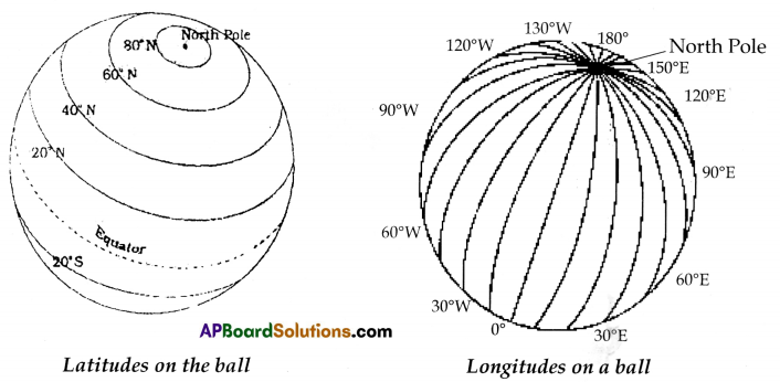
Draw the latitudes and longitudes on the surface of a ball. (Mapping Skills)
Answer:
Question 6.
‘The Sun always rises in the East’ – Find out the reasons for this. (Conceptual understanding)
Answer:
We all have learnt about the four directions i.e., East, West, South and North. We can locate the North and the South poles on the Globe. To the right side is the East and to the left side is the West.
The Earth rotates every day from the West to the East, By rotating the globe, we can understand that the sunrises in the East and sets in the West. By this, we can understand the sunrises in the East as we on the Earth moving towards East.
![]()
Question 7.
Why do we draw imaginary lines on the globe or map?(Conceptual understanding)
Answer:
We can see many lines crossing on the globe. Some run from the North Pole to the South Pole. While others run around the Earth from the West to the East. These imaginary lines drawn up by globe/map help us locate places on the globe and map.
Question 8.
What is the effort put up by scientists and sailors to know about earth? (Appreciation and Sensitivity)
Answer:
- Earth is the only planet that support life as far as human knowledge is concerned.
- The curiosity to know about shape of earth, other places present on earth, position and place of earth in solar system etc.. have been started in ancient centuries itself.
- Waterways are the only cheapest and easiest way to travel long distances in earlier days, So, generally sailors started exploring new parts of the world and revealed them to outer world.
- Gradually, normal people developed interest to know more about earth and used to start sailing in search of new facts about earth.
- Such were the continents like America discovered by Columbus, Vascodagomas discover of route to India started new way of trade relations between Asia – Africa and Europe.
- Several scientists also developed many scientific methods based on movement of earth in direction to sun, (rotation, revolution etc), observed geographical evidence etc., Eg: Continental drift theory of Alfred Weber.
Question 9.
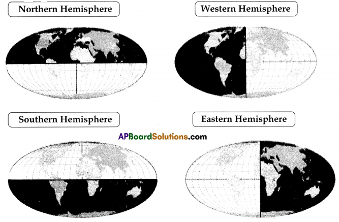
Observe the following pictures and fill the boxes by writing the names of the shaded hemisphere. (Mapping skills)
Answer:
Question 10.
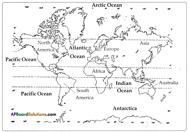
Point out the continents and oceans in the world map given below. (Mapping Skills)
Answer:
(In-text Questions)
Text Book Page No. 9
Question 1.
Can you explain why half of the Eieth is not visible in this photograph?
Answer:
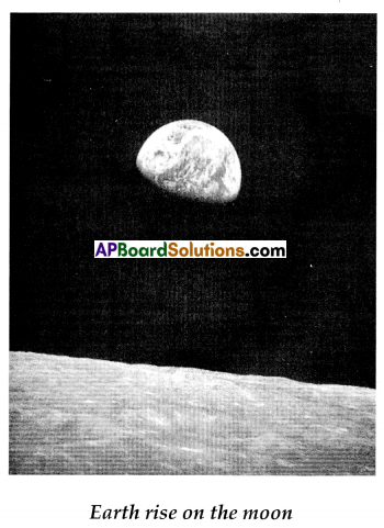
We can see only one part of the Earth which receive. sunshine and the bottom portion of the earth is not visible the sun’s rays do not fall on.
Text Book Page No. 10
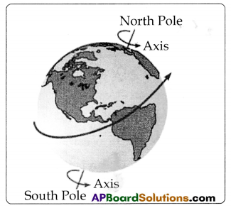
Question 2.
Give each student a chance to take the globe in her/his hand and look at t carefully. See bow the earth rotate,.
Answer:
The earth rotates, trou, the west to the east.
![]()
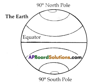
Question 3.
With the help of your teacher, locate the North Pole, the South Pole and the Equator.
Answer:
Question 4.
Take a globe and run your finger along the path taken by Columbus to reach America
and on the imaginary route to reach India.
Answer:
Columbus travelled towards west and reached America. He could have reached India if he travelled towards south, and en route Africa towards east.
Question 5.
Describe the sea in a few lines or draw a picture of the sea?
Answer:
The sea water is saltish in taste. The sea stretches for hundreds and thousands of kilometres just endless water. It may take many days or even months to travel From one end to the other in the sea.
Question 6.
State the main difference between the water you drink and the sea water?
Answer:
The seawater tastes salty whereas the water we drink tastes sweet.
Question 7.
One of the oceans is frozen into ice – find out its name.
Answer:
Antarctica,
Question 8.
Observe the globe and write down the names of the four great oceans.
Answer:
- The Pacific Ocean
- The Indian Ocean
- The Arctic Ocean and
- The Atlantic Ocean.
Text Book Page No. 11
Question 9.
Which of these is the largest ocean – underline It.
Answer:
Pacific Ocean
Question 10.
Find out the names of the continents and write them down.
Answer:
- Asia
- Europe
- Africa
- Australia
- North America
- South America and
- Antarctica.
Question 11.
One of these continents Is actually covered with ice – find out its name and location.
Answer:
Antarctica continent is actually covered with ice. It is the Southpole. actually a huge accumulation of ice. This is otherwise called the Antarctic Shield of ice.
Question 12.
Look for India on the Globe – name the continent in which India is located.
Answer:
Asia.
![]()
Question 13.
Similarly look for the countries you have heard of.
Answer:
Srilanka, Japan, Philippines, Indonesia, Australia, Pakistan, US.A.
(Additional Questions)
Question 1.
Why does the Earth look like a ‘blue’ moon?
Answer:
The Earth looks like blue moon because a large portion of the Earth is covered with oceans i.e. water.
Question 2.
Write the beauty of the earth?
Answer:
- The earth is the only planet that has water and life.
- It is called blue planet because of water which is seen blue in colour.
- The layor ‘atmosphere’ supports the life on the earth.
- We find rich flora and fauna only on the earth.
Question 3.
Explain briefly about ‘The Earth’?
Answer:
The Earth is like a ball – spherical in shape. Globe is a model of the Earth. Earth looks like a blue moon We never fall off the Earth because the Earth acts like a very powerful magnet which pulls us towards it. The Earth bulges slightly in the middle around a line called Equator. It is a little bit pressed at the two poles in the North and the South.
Seas and Oceans stretch For hundreds and thousands of Kilometres – Just endless water. There are four great oceans named the Pacific, the Atlantic, the Indian and the Arctic Oceans.
The large land masses, on which we can live, are called continents. There are seven
continents –
- Asia
- Europe
- Africa
- Australia
- North America
- South America and
- Antarctica.
Question 4.
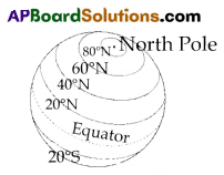
What do you know about latitudes?
Answer:
The imaginary lines drawn on the globe from the West to the East are called latitudes. The longest of these lines is called Equator; it divides the globe into two equal halves. These imaginary lines drawn on the map help us locate places on the globe and maps.
Question 5.
What do you know about longitudes?
Answer:
The imaginary lines drawn on the globe from North Pole to South Pole are called longitudes. These lines are all of the same length. There are two main longitudes the Green Wich Line which is also called the Odegree longitude and the International Date Line.
Read the given information and answer the questions in one or two sentences. (Information skills)
| Name of the Ocean | Its importance |
| 1. The Pacific Ocean | The deepest Ocean. |
| 2. The Indian Ocean | Asia, Africa and Europe. |
| 3. The Atlantic Ocean | It is in ‘S’ shape. It lies between ‘America and Europe. |
| 4. The Arctic Ocean | It is frozen into ice. |
1. Which Ocean is spread among three continents?
Answer:
Indian Ocean
2. Which Ocean is the deepest among all the Oceans?
Answer:
The Pacific ocean
3. Which Ocean is frozen into ice?
Answer:
Arctic Ocean.
Question 7.
How are the longitudes and latitudes useful to us?
Answer:
- Longitudes help us to calculate time.
- The longitude running through the Greenwich near London is known as the prime meridian having the same time at all places on the Earth.
- Together the latitudes and longitudes create a net that covers the map and helps us to locate the places.
Question 8.
What would happen if there are no longitudes and latitudes,
Answer:
We cannot know time perfectly. We can not locate distant places particularly while travelling in aeroplanes.
(MAPPING SKILLS)
A) Map Pointing:
1. Locate the seven continents in the given world map.
Answer:
B) Map Reading:
Observe carefully the map and answer the questions.
1. What are the two continents that are present in the map?
Answer:
North America and South America.
2. Which continent touches the North Pole?
Answer:
North America.
![]()
3. To which direction the arrow mark moves to?
Answer:
To the East.
Two Mark Questions
Question 1.
What is a Globe?
Answer:
Globe is the model of the Earth
Question 2.
What ¡s the shape of the Earth?
Answer:
The Earth is spherical in shape. It is a bit pressed at the poles and huìge slightly in the middle.
Question 3.
Who was Columbus?
Answer:
Columbus was an Italian explorer who discovered sea route to the Caribbean islands in 1492 AD.
Question 4.
How many oceans are there? What are they?
Answer:
There are four great oceans. They are
- The Pacific Ocean,
- The Atlantic Ocean.
- The Indian Ocean,
- The Arctic Ocean
Question 5.
What are continents?
Answer:
The large land masses on the Earth’s oceans are called continents.
Question 6.
What is an Axis?
Answer:
The imaginary line passing through the interior of the Earth is known as the Axis of the Earth.
Question 7.
How does the Earth rotates?
Answer:
The Earth rotates from West to East.
Question 8.
How many continents are there? What are they?
Answer:
There are seven continents They are
- The Asia,
- The Europe,
- The Africa,
- The Australia,
- The North America,
- The South America,
- The Antarctica.
Question 9.
What are attitudes?
Answer:
The imaginary lines that are drawn from the West to the East on the globe are known as latitudes.
![]()
Question 10.
What are longitudes?
Answer:
The imaginary lines drawn on the globe from the North to the South pole are called
longitudes.
(Objective Type Questions)
Question 1.
The shape of the planet Earth is ( )
A) Spherical
B) Flat
C) Irregular
Answer:
A) Spherical
Question 2.
Globe is a model of
A) The moon
B) The Earth
C) The Sun
Answer:
B) The Earth
Question 3.
How does the Earth look like? ( )
A) Atlas
B) Moon
C) Blue Moon
Answer:
C) Blue Moon
Question 4.
We never fall off the Earth because it acts like ( )
A) A magnet
B) A batters
C) A detractor
Answer:
A) A magnet
Question 5.
The line which is in middle around the Earth is called ( )
A) North pole
B) South pole
C) The Equator
Answer:
C) The Equator
Question 6.
An Italian explorer who reached Caribbean Sea ( )
A) Columbus
B) Archniedes
C) Vasco de Gama
Answer:
A) Columbus
Question 7.
If you live in A.P. you would see the
A) Indian Ocean
B) Bay of Bengal
C) Pacific Ocean
Answer:
B) Bay of Bengal
![]()
Question 8.
These water bodies stretch for hundreds and thousands of kilometres.
A) Canal
B) Seas
C) Seas and Oceans
Answer:
C) Seas and Oceans
Question 9.
One of the Oceans is frozen into ice.
A) Arctic Ocean
B) Atlantic Ocean
C) North Sea
Answer:
A) Arctic Ocean
Question 10.
The largest among the four great oceans
A) Atlantic
B) Indian
C) Pacific
Answer:
C) Pacific
Question 11.
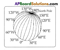
The lines shown on the globe in the picture.
A) latitudes
B) Longitudes
C) Grid
D) Poles
Answer:
B) Longitudes
Question 12.
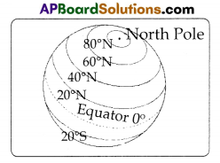
The lines shown on the globe in the picture. ( )
A) Latitudes
B) Longitudes
C) Grid
D) Poles
Answer:
A) Latitudes
Question 13.
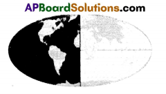
Identify the shaded hemisphere ( )
A) Northern hemisphere
B) Southern hemisphere
C) Eastern hemisphere
D) Western hemisphere
Answer:
D) Western hemisphere
![]()
Question 14.
The continent shown with ‘? mark is ( )
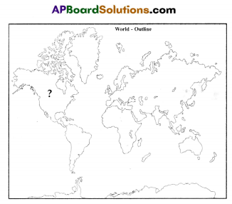
A) Asia
B) Europe
C) North America
D) South America
Answer:
C) North America
Question 15.
The longest latitude in the globe. ( )
A) 20°N
B) 40°N
C) 60°N
D) 0°
Answer:
D) 0°