Regular practice with TS 6th Class Social Bits with Answers 1st Lesson Reading and Making Maps improves students’ confidence and readiness for assessments and examinations.
TS 6th Class Social Bits 1st Lesson Reading and Making Maps
Objective Type Questions.
Choose the correct answer and write its letter in the bracket.
1. The top of the arrow mark indicates the direction
(A) North
(B) South
(C) East
(D) West
Answer:
(A) North
2. The direction directly opposite to the North is called the
(A) South
(B) East
(C) West
(D) None of them
Answer:
(A) South
![]()
3. Maps showing the distribution of population conditions are called
(A) Population maps
(B) Political maps
(C) Physical maps
(D) Weather maps
Answer:
(A) Population maps
4. Look at the following picture carefully.
(i) The girl in the middle is facing the rising Sun The object in the direction of her right hand side is …………..
(A) House
(B) Trees
(C) Well
(D) Rising Sun
Answer:
(C) Well
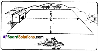
(ii) The object in the direction of her left hand side is ………………
A) Rising Sun
B) Trees
C) House
D) Well
Answer:
B) Trees
5. The direction in which the sun sets.
A) East
B) West
C) North
D) South
Answer:
B) West
6. In which direction does the west lay to a person who stands facing east?
A) right – hand side
B) left – hand side
C) backside
D) none
Answer:
C) backside
![]()
7. In which direction does the north lay to a person who stands facing east ?
A) left-hand side
B) right-hand side
C) backside
D) all the above
Answer:
A) left-hand side
8. In which direction does the south lay to a person who stands facing east ?
A) left-hand side
B) right-hand side
C) backside
D) none
Answer:
B) right-hand side
9. This can be expressed always relative to something.
A) direction
B) system
C) relation
D) corner
Answer:
A) direction
10. Usually, maps are prepared in such a manner that north is at the …………….of the map.
A) top
B) bottom
C) right-hand side
D) left-hand side
Answer:
A) top
11. Usually, maps are prepared in such a manner that south is at the of the map.
A) top
B) bottom
C) right-hand side
D) left-hand side
Answer:
B) bottom
12. This is used to indicate distance on the map.
A) symbol
B) direction
C) scale
D) none
Answer:
13. The scale is the of distance between two points on the map to the actual distance on the ground.
A) ratio
B) axes
C) both A and B
D) none
Answer:
B) axes
![]()
14. Map makers prepare symbols appropriate to their needs. But some common symbols which are called are also used.
A) Heriditary symbols
B) Conventional symbols
C) Irrelative symbols
D) Improper symbols
Answer:
B) Conventional symbols
Study the map to find out how to use the symbols and answer the questions from 15 to 18.
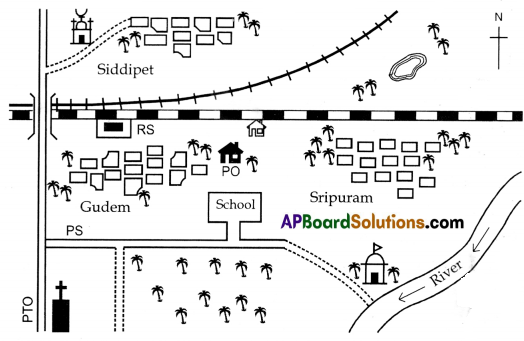
15. The symbol ![]() indicates
indicates
A) Well
B) River
C) Tree
D) Post Office
Answer:
C) Tree
16. The symbol indicates
A) Broad gauge
B) Metre gauge
C) School
D) Masjid
Answer:
A) Broad gauge
17. The symbol  indicates
A) Well
B) School
C) Temple
D) Church
Answer:
C) Temple
18. The symbol indicates
A) Well
B) School
C) Tank
D) Police Station
Answer:
C) Tank
19. Map makers prepare ………….. appropriate to their needs.
A) Symbols
B) Water bodies
C) Globes
D) Directions
Answer:
A) Symbols
20. If you stand facing the East, all the things to your right hand side will be towards …………..
A) North
B) East
C) West
D) South
Answer:
D) South
![]()
21. If you are facing the East, all the things behind you will be ………….
A) North
B) South
C) West
D) East
Answer:
C) West
22. We use ………………. for showing the actual distance on the ground in a reduced manner on a map.
A) Globe
B) Scale
C) Maps
D) Directions
Answer:
C) Maps