Regular practice with TS 6th Class Social Bits with Answers 2nd Lesson Globe – A Model of the Earth improves students’ confidence and readiness for assessments and examinations.
TS 6th Class Social Bits 2nd Lesson Globe – A Model of the Earth
Objective Type Questions
Choose the correct answer and write its letter in the bracket.
1. Zero degree latitude is …………….
(A) The. Tropic of Cancer
(B) The Tropic of Capricorn
(C) The Equator
(D) 6672° South latitude
Answer:
(C) The Equator
2. The total number of latitudes in both the hemispheres is …………….
(A) 180
(B) 90
(C) 100
(D) 360
Answer:
(A) 180
![]()
3. Meridians are ……………
(A) Longitudes
(B) Latitudes
(C) Poles
(D) None of the above
Answer:
(A) Longitudes
4. The longitude on which Greenwich is ………………
A) 10°longitude
B) \(66^1 /_2^{\circ}\) longitude
C) 0°longitude
D) 180° longitude
Answer:
C) 0°longitude
5. A globe is the …………….
(A) model of the Earth
(B) model of the Marks
(C) model of the Jupiter
(D) model of Saturn
Answer:
(A) model of the Earth
6. A globe shows the ………………
(A) shape of the Earth
(B) water and land masses
(C) oceans
(D) all the above
Answer:
(D) all the above
![]()
7. The reason behind the earth’s strength
(A) Magnet
B) Iron
C) Manganese
D) Aluminium
Answer:
(A) Magnet
8. The concept of lines on the globe called
A) Latitudes
B) Longitudes
C) Latitudes and Longitudes
D) International Data lines
Answer:
C) Latitudes and Longitudes
9. Lines on the globe were well known to
A) Aristotle
B) Aryabhatta
C) Charaka
D) Columbus
Answer:
B) Aryabhatta
10. Find out the correct statement.
1) Antarctica continent supports to human life.
2) Antarctica continent only supports for research stations.
A) 1 only
B) 2 only
C) both 1 & 2
D) both 1 & 2 or wrong
Answer:
B) 2 only
11. The darken place in the picture shows
A) Eastern hemisphere
B) Southern hemisphere
C) Northern hemisphere
D) Western hemisphere
Answer:
C) Northern hemisphere
12. The North and South poles on the earth are covered with
A) water
B) ice
C) air
D) heat
Answer:
B) ice
13. These are located in the continents.
A) villages
B) towns
C) cities
D) all the above
Answer:
D) all the above
14. If you face north on the globe, the ………….. is on your right.
A) latitude
B) longitude
C) axis
D) orbit
Answer:
A) latitude
![]()
15. The imaginary horizontal lines on, the earth are
A) latitudes
B) longitudes
C) parallels
D) Both A & C
Answer:
B) longitudes
16. The imaginary horizontal lines on, the earth are ………….
A) latitudes
B) longitudes
C) parallels
D) Both A & C
17. The longest latitude
A) Tropic of Cancer
B) Tropic of Capricorn
C) Equator
D) Arctic circle
Answer:
C) Equator
18. The hemisphere that lies between the Equator and North pole is …………
A) southern hemisphere
B) northern hemisphere ’
C) eastern hemisphere
D) western hemisphere
Answer:
B) northern hemisphere ’
![]()
19. The hemisphere that lies between the Equator and the South pole is ……………
A) southern hemisphere
B) northern hemisphere
C) eastern hemisphere
D) western hemisphere
Answer:
A) southern hemisphere
20. India is located in …………..
A) northern hemisphere
B) eastern hemisphere
C) southern hemisphere
D) Both A & B .
Answer:
D) Both A & B .
21. The vertical lines that connect the poles are called as …………
A) latitudes
B) longitudes
C) half-circles
D) Both B & C
Answer:
D) Both B & C
22. The other name of 0° longitude ……………
A) Greenwich longitude
B) the longest longitude
C) 180° western longitude
D) All the above
Answer:
A) Greenwich longitude
![]()
23. Which one is called the International Date Line ?
A) 180° longitude
B) \(821 / 2^{\circ}\) East longitude
C) 90° West Jongitude
D) 95° West longitude
Answer:
A) 180° longitude
24. The Earth rotates every day from …………… to …………….
A) North to South
B)East to West
C) West to East
D) South to North
Answer:
C) West to East
25. You can see large land masses on the globe which are called …………..
A) Oceans
B) Seas
C) Plateaus
D) Continents
Answer:
D) Continents
26. ………….. are the two points on the opposite ends of the Earth.
A) Latitudes
B) Longitudes
C) Seas
D) Poles
Answer:
D) Poles
27. Around …………. AD scientists and sea-fares began to figure out that the Earth must be like a ball.
A) 1400 AD
B) 1300 AD
C) 1400 BC
D) 1300 BC
Answer:
A) 1400 AD
28. Which of these do you think is the largest ocean?
A) Atlantic
B) Pacific
C) Indian
D) Arctic
Answer:
B) Pacific
29. 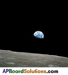
what dose the picture shows?
A) Moon from the earth
B) Sun from the earth
C) Earth from the moon
D) Earth rise on the moon
Answer:
D) Earth rise on the moon
![]()
30. Why the bottom portion of the earth is not visible in this picture ?
A) That portion is not receiving the sunshine
B) That portion is receiving the sunshine
C) That day is Aniav
D) None of the above
Answer:
A) That portion is not receiving the sunshine
31. 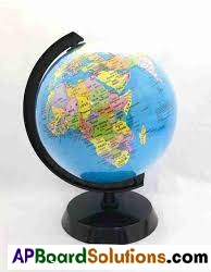
What does the picture shows ?
A) Earth
B) Moon
C) Globe
D) Sun
Answer:
C) Globe
32. Which of the folio wing ocean is in frozen state ?
A) Atlantic
B) Pacific
C) Antarctic
D) Indian
Answer:
C) Antarctic
33. Which of the following continent is in frozen state ?
A) Australia
B) Europe
C) Arctic
D) Antarctic
Answer:
D) Antarctic
![]()
34. Equator: Tropical zone :: Poles: …………….
A) Temperature
B) Torrid zone
C) Frigid zone
D) None
Answer:
C) Frigid zone
35. Why did “the .sum always rises in the: east”. Find the reason.
A) The earth’s rotation from west to east
B) The earth rotate from east to west
C) Because the earth is like a ball
D) None
Answer:
A) The earth’s rotation from west to east
36. Latitudes helps us
A) To find the place
B) To know the time
C) Both A &: B
D) None
Answer:
A) To find the place
37. Longitudes helps us ………………
A) To know the local time
B) To know the location of the place
C) Both A & B
D) None
Answer:
A) To know the local time