Telangana SCERT 7th Class Social Guide Pdf Telangana 5th Lesson Europe Textbook Questions and Answers.
TS 7th Class Social 5th Lesson Questions and Answers – Europe
Improve Your Learning
Question 1.
The Atlantic Ocean has had a deep impact on the climate of Europe as well as on the life and livelihood of the people of Europe. Collect relevant information and write an essay on the theme? (AS,)
Answer:
- The winds blowing from Atlantic Ocean influence the climate of Europe. The climate is cold in Western Europe due to these winds. But it is not below freezing point due to westerlies.
- The westerlies that blow from Atlantic Ocean carry a lot of moisture and cause rainfall throughout the year in northern and western Europe.
- The gulf streams of Atlantic Ocean are very good for fish breàding resulting in developing fishery industry.
- Fish and its products are important part in the livelihood of Western Europe.
- As there are rains all through the year caused by Atlantic ocean, the European plains are suitable for agriculture.
- Due ‘to gulf stream of the Atlantic Ocean, the shipping industry developed as even in winters, the waters do not freeze.
Question 2.
Answer these questions with the help of the maps given in the chapter:
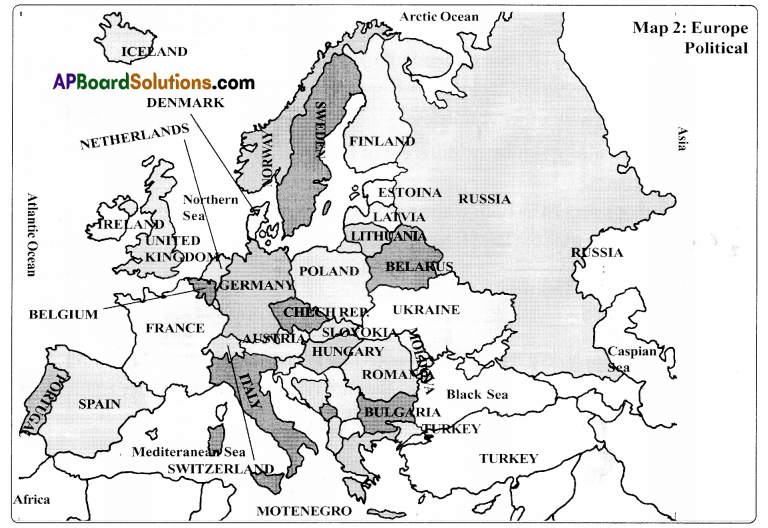
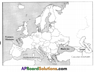
a. Which of the following is not a landlocked (surrounded by land) country (Hungary/Romania/Poland/Switzerland)? (Conceptual Understanding)
Answer:
Romania and Poland are not landlocked countries.
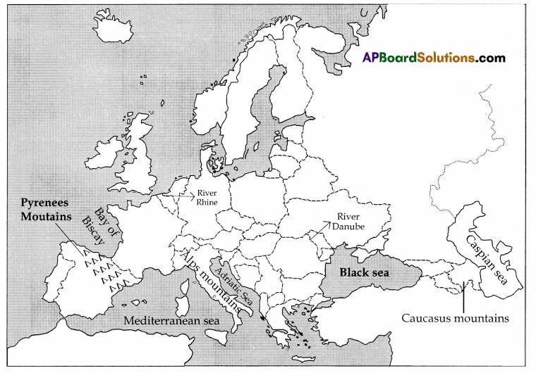
b. Which mountains lie between the Caspian Sea and the Black Sea – (Alps/Caucasus mountains)? (conceptual Underctandiog)
Answer:
Caucasus.
c. Which countries are on the shores of the Arctic Ocean (Russia/Germany/Sweden/Norway)?
Answer:
Russia. Norway.
d. Can a ship sail from the Black Sea to the Atlantic Ocean? If yes, trace the route it will have to take.
Answer:
Yes, a ship can sail from the Black Sea to Atlantic Ocean.
Route: Black Sea → Bosporus Strait → Sea of Marmara → Dardanelles →Aegean sea → Mediterranean sea → Atlantic Ocean.
![]()
Question 3.
Why are harbours built in deep gulfs or bays?
Answer:
Gulfs and bays are parts of a sea enclosed by land on three sides. Deep gulfs or bays are preferred for building harbours as large ships can be anchored in them. Ships need deep waters so that their bottom do not touch the sea floor.
Question 4.
Why are the winters less severe in Western Europe than in Eastern Europe?
Answer:
The winters are less severe in Western Europe than in Eastern Europe because of the nearness of Western Europe to the Atlantic ocean. Eg : The countries like Poland and Russia have severe winters while France and Great Britain are comparatively warmer.
Question 5.
Name four countries on the coast of the Black Sea. (AS,)
Answer:
- Bulgaria
- Romania
- Moldova
- Ukraine
Russia and Turkey too are on the coast of the Black Sea. But Turkey is an Asian country.
Question 6.
How do the western less benefit the people of Western Europe?
Answer:
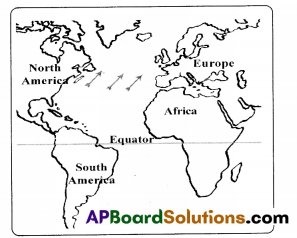
- Winds blow all the year round from the Atlantic Ocean towards Europe.
- Since they blow from the west, these winds are called westerlies.
- These winds blow from the south-west towards the northeast.
- These winds are warmer than the land temperature and are also moist.
- The climate of Western Europe is affected by these warm and moist winds all the year round, as they blow throughout the year. This is the benefit of the people of Western Europe.
Question 7.
What are the characteristics of the Mediterranean climate? Name the countries which have a Mediterranean climate. (Conceptual Understanding)
Answer:
Characteristics of the Mediterranean climate:
- Southern part of Europe experiences the Mediterranean type of climate.
- The winters here are not too cold and summers are warm.
- It does not rain all through the year.
- The westerlies blow in this region during winter months only. These winds bring rain to the Mediterranean countries.
- Rainy winters and dry summers are termed as Mediterranean climates.’
- The countries which have a Mediterranean climate are Greece, Spain, France, Italy, l3ulgaira, Vatican, Portugal, Montenegro, Bosnia, Yugoslavia and Albania.
Question 8.
What are the factors that limit European agriculture?
Answer:
- A very large part of Europe is mountainous and not suitable for agriculture.
- Some countries have very little agricultural land.
- In eastern and northern Europe, it is not possible to cultivate the land in winter due to the extreme cold.
Question 9.
Name the important crops of Southern Europe.
Answer:
Wheat, barley, oats, rye, sugar beet, potato and fruit cultivation.
![]()
Question 10.
How can you say that the trade awl cultural relations have been developed among the countries due to the discovery of new sea routes by European sailors?
Answer:
- From the very ancient times, the people of Europe have been trading with India and other countries of Asia like Indonesia and China.
- But after Columbus, the Europeans discovered several sea routes.
- They could now sail not only to America but also to different parts of Africa, India and Australia.
- They traded with these countries and amassed immense wealth, which was used to develop industries in Europe.
- The industrial revolution started in England and soon spread to other European countries.
- They established colonies and started trading with the Asian, African countries.
- Thus, we can say that the trade and the cultural relations have been developed among the countries due to the discovery of new sea – routes by European traders.
Question 11.
Read the last part of this chapter and comment on it. (Reading the text (given), understanding and interpretation)
Industrial Revolution in Europe:
The industrial revolution as you know started in England around 2750 and soon factory
production spread to Fra ncç. Holland, Germany, Spain. Ru&cia etc. Countries like England and Germany, which had large reserves of coal and other minerals, took lead in developing new industries, However, as times changed, European countries began to use less and less of their own mineral resources and relied on imports from other countries. The old ruining towns and old factories were dosed down and new factories grew in new areas.
Industrialisation also enabled the European countries to import agricultural goods from other countries. Thus, they relied less on the agriculture of their countries for their food and raw material requirements. Hence, Europe became dependent upon trade with other countries. Initially, this trade was with their colonies in Asia, Africa and America. However as the colonies became independent, they had to develop new ways of trading with them.
Answer:
Impact of Industrial Revolution in Europe:
- The European countries started relieing on imports from other countries.
- Old factories were closed and new factories were established.
- Industrial Revolution enabled them to import agricultural goods from other countries.
- Hence. Europe became dependent upon trade with other countries.
- Later, however as the colonies became independent, they developed new ways of trading with other countries.
Question 12.
How Is agriculture similar or different in Europe from that of our country?
Answer:
Similarities:
- The crops grown in both countries are wheat, corn and barley.
- In both countries, big landlords are there. But the small farmers in both countries
abandoned agriculture and took employment in the cities in industries or other services.
Differences:
- In our country. We have three seasons like Winter, Summer and Autumn. But in Europe four main seasons are there, they are Winter Spring, Summer and Autumn.
- Rainy is the season of agriculture in India but Summer is the season of agriculture in Europe.
- In our country agriculture is possible for ten months in a year but in Europe, it is possible for six months only.
Intext Question
Text Book Page No. 42
Question 1.
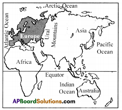
Name the ocean to the west of Europe. (Conceptual understanding)
Answer:
Atlantic Ocean is on the west of Europe.
Question 2.
Look in the atlas and find the name of the sea just south of Europe. (Conceptual understanding)
Answer:
The name of the sea just south of Europe is Mediterranean Sea.
Question 3.
Name the mountains to the east of Europe. (Conceptual understanding)
Answer:
Ural mountains are to the east of Europe.
![]()
Text Book Page No. 43
Map Reading Skills
Question 4.
Now you are familiar with the taxation of Europe, You can look at the countries of Europe. Look at Map 2 to find out their names, have you heard of some of these countries before?
Answer:
France, Italy, Russia, England, Denmark, Portugal. Germany, Norway, Sweden, Greenland, Iceland and Ireland.
Question 5.
Write the names of the countries of Europe on this map and colour them. See that no two neighbouring countries have the same colour.
Answer:
Question 6.
The Alps stretch across several countries. Find out the names of these countries by comparing Maps 2 and 4. (Europe political map/Europe physical map)
Answer:
South France, Switzerland, Northern Italy, Austria, Germany, Chech.
Question 7.
Write the names of two rivers starting from the Alps.
Answer:
River Rhine, Po River, Danube River.
Question 8.
Name the countries across whose borders the Pyrenees stretch.
Answer:
France, Spain and Andorra (trapped between Spain and France) on the Pyrenees mountain range.
(Note:- Pyrenees Runs along the southern border of France separates France from Spain Extends in east-west direction)
Question 9.
Name the mountains stretching in the Eastern Europe.
Answer:
Ural mountains and Caucasus mountains.
![]()
Question 10.
Identify the other mountains in Europe and prepare a table.
Answer:
| Mountains | Location |
| 1) Scandinavian Ranges | Located in Norway |
| 2) Ural Mountains | Located between Asia and Europe |
| 3) Caucasus Mountains | Located between Black Sea and Caspian Sea. |
| 4) Alps Mountains | Located to the north of Italy, especially in Switzerland and Austria. |
| 5) Dinaric Alps | Situated in Balcon Peninsular. |
| 6) Pennine Range | Situated in Britain. |
| 7) Carpathian Ranges | Situated to the west of Black Sea. |
| 8) Pyrenees Mountains | Situated between Spain and France. |
| 9) Apennines Mountains | Located in Italy. |
Text Book Page No. 47
Study Maps 2 and 4 (Europe political map/Europe physical map) to answer the following questions:
Question 11.
a) Names of countries through which the Rhine flows:
1. …………………….. 2. ………………….. 3. ………………. 4. ……………….
Answer:
- Switzerland
- France
- Belgium
- Germany
- Netherlands
b) Names of countries through which the Danube flows:
1. …………… 2. ……………. 3. ……………… 4. ………………. 5. ……………… .
Answer:
1) Germany
2) Austria
3) Hungary
4) Slovakia
5) Bulgaria
c) Names of two mountain ranges on the border of the Hungarian plains.
1. ……………………… .
2. ……………………….. .
Answer:
1) Carpathiar mountains
2) Dinaric Alps mountains
d) Names of countries which ring the Black Sea.
1. ……………….. 2. …………………. 3. …………………. 4. …………………. 5. ………………….
Answer:
1) Turkey
2) Bulgaria
3) Romania
4) Moldova
5) Ukraine
e) Names of oceans or seas into which the following rivers empty themselves:
| River | Ocean/Sea |
| 1) Seine | |
| 2) Rhine | |
| 3) Oder | |
| 4) Po | |
| 5) Danube | |
| 6) Vistula | |
| 7) Volga | |
| 8) Dniper | |
| 9) Don | |
| 10) Dvina |
Answer:
| River | Ocean/Sea |
| 1) Seine | North sea |
| 2) Rhine | North sea |
| 3) Oder | Baltic sea |
| 4) Po | Adriatic sea |
| 5) Danube | Black sea |
| 6) Vistula | Baltic Sea |
| 7) ‘Volga | Caspian sea |
| 8) Dniper | Black sea |
| 9) Don | Black Sea |
| 10) Dvina | Black Sea |
Question 12.
Which is a peninsula- Greece or France?
Answer:
Greece is a peninsula.
Question 13.
Are Spain and Portugal peninsulas too?
Answer:
Spain is a peninsula, Portugal is not a peninsula.
Question 14.
Name the mountain range in the Scandinavian Peninsula.
Answer:
The mountain range in the Scandinavian peninsula is Scandinavian ranges.
Text Book Page No. 48
Question 15.
Find out the names of some other island countries of Europe.
Answer:
- Ireland
- Iceland
- Great Britain
Question 16.
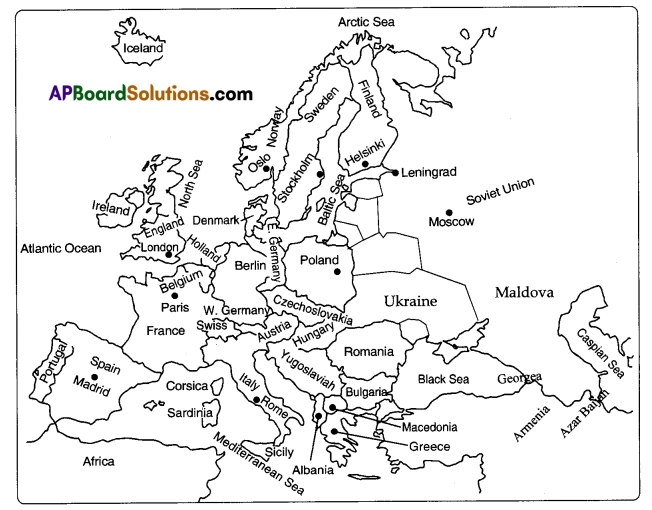
Find out from Map 4 the names of the countries on the three sides of the Baltic Sea.
Answer:
Sweden, Finland, Poland, Estonia, Lithuania, Latvia and Germany.
Question 17.
Why is the climate of Europe so different from ours? Discuss in the class.
Answer:
- As one goes away from equator the temperature decreases. Hence Europe has a cooler climate than ours.
- The climate of Western Europe is affected by westerlies which are warm and moist.
- Due to that there are light showers all round the year in western Europe.
- In India, we eagerly wait for coal showers whereas the people of Western Europe wait for bright sunny days.
- Most of the European countries experience snowfall in winter. Their summers, too, are not as warm as ours.
Question 18.
Look at a globe to see how far is north Europe is from the Equator.
Answer:
Europe extends between 35° to 72° north latitude. So the north Europe is 720 distance from Equator nearly 2500 Krns from the Equator.
![]()
Question 19.
Is Europe farther north than India?
Answer:
Yes. Europe is even farther north than India.
Question 20.
Will Norway be warmer than Italy? Why?
Answer:
Norway is nearer to Arctic Ocean. (Frozen polar region). So it is cooler than Italy.
Question 21.
Locate the regions of Europe along with Atlantic Ocean and state whether they are on eastern side or western side.
Answer:
The western part of the Europe is along the Atlantic Ocean.
Text Book Page No. 49
Question 22.
Look at the Europe map and tell which country is warmer. Spain or in Slovakia?
Answer:
- Spain is on the shore of Atlantic on western part of Europe. The climate is warm due to North Atlantic Drift.”
- Slovakia, which is on the eastern part, is colder.
Question 23.
Can you guess the impact of Westerfies on Europe? (Conceptual understanding)
Answer:
- The climate of Western Europe is affected by the warm and moist winds as they blow throughout the year.
- That is the reason why it rains throughout the year in northern and western Europe.
- The skies are usually clouded.
Text Book Page No. 50
Question 24.
Why do you think the climate of Eastern Europe is not so strongly affected by the warm currents? (Conceptual understanding)
Answer:
- The Atlantic Ocean which has warm currents is in the western part of Europe.
- The eastern Europe is far from the Atlantic ocean.
- So, the eastern Europe is not so strongly affected by the warm current.
Fill in the blanks:
Question 25.
a. The water near the Equator are …………………. . (warm/cool/icy cold)
Answer:
warm
b. Starting near the Equator, the Gulf Stream reaches the coast of America. (eastern/Western/northern)
Answer:
Eastern.
c. The Gulf Stream flows in the …………………… . (Atlantic Ocean/Mediterranean SeaBlack Sea)
Answer:
Atlantic Ocean.
![]()
d. The waters of the Gulf Stream which hit the European coast are ……………. . (cold/warm/icy cold)
Answer:
warm.
e. The Westerlies blow from the Atlantic Ocean towards Europe ………………. . (in winter /in summer all round the year)
Answer:
all round the year.
f. These winds are (dry/moist/icy)
Answer:
moist.
Question 26.
What differences do you notice between the climates of India and West Europe? (Conceptual understanding)
Answer:
ln Europe, the westerlies, which blow throughout the year also bring ample moisture to northern and western Europe since these winds blow from the sea carry a lot of moisture and regularly cause rainfall. This is why it rains throughout the year in northern and western Europe.
In India, it rains only for a few months. There are light showers all round the year in Western Europe. and usually clouded. While we, in India, eagerly await cool showers, the people of Western Europe long for bright sunny days.
Question 27.
Name the countries which would benefit from the Dogger Bank. (Conceptual understanding)
Answer:
East of the United Kingdom, Denmark and Netherlands would benefit from the Dogger banks. The North Sea near Britain is called Dogger Bank.
Question 28.
Look at the Map of Europe and name four Mediterranean countries. (Mapping skills)
Answer:
Spain, Bulgaria, Italy and Portugal.
Text Book Page No. 48
Question 29.
Compare Mediterranean and Telangana climates on the following aspects: Seasons Rainfall. (Information Skills)
Answer:
| Mediterranean climate | Telangana climate |
| 1. The winters here are nor too cold and summers are warm. | 1. Tropical monsoon type of climate add is observed |
| 2. The westerlies blow here during the winter months only. | 2. The south-west monsoon and the northeast monsoon occur in Telangana |
| 3. The climate is very good for growing juicy fruits. | |
| Rainfall 1. Itdnesnotrainali through the year as In western Europe. |
1. In Telangana rainfall receives due to the south-west monsoon season in the second week of June and it spreads all over the state by the end of June |
| 2. The westerlies bring rain to the Mediterranean countries in other words It rains here only In winter. |
Question 30.
When does it rain most in your state, in summer months or in winter months? (Information skills)
Answer:
In Telangana, a year can be dis Ided into 3 seasons
- Winter season – (January to February)
- Summer season – (March to mid – June).
- Rainy season Southwest monsoon season – (m.d June to September)
Northeast monsoon season – (October to December)
In these seasons during rainy season (or) South West monsoon season, it rains sliest os our state.
Question 31.
Find out if your region gets light winter, shower and the name given to it in rains regional language. (Conceptual understanding)
Answer:
In our region, light winter showers are called as “Derpavati Stusurlu.
Question 32.
Fishing industry is importance in ………………. (Conceptual understanding)
Answer:
a) Western Europe.
Question 33.
Whereas fruit growing Is Important in ……………….. .(Conceptual understanding)
Answer:
Southern Europe.
Question 34.
Which of these crops grow In our state at which area?
Answer:
| Wheat | Adilabad, Medak |
| Corn | Medak, Karimnagar |
| Millets | Mahabubnagar |
Question 35.
Why is it possible to raise two crops in the Mediterranean countries? (Reading the text (given), understanding and interpretation)
In eastern and northern Europe, it is not possible to cultivate the land in winter as snow covers it for almost six months. The snow begins to melt only in spring leaving very little time for crops to ripen. It is in spring that sowing takes place and crops ripen in the summer months and are ready for harvest in autumn. As a result, it is possible to raise only one crop in a year in these parts. However, in southern Europe, it is possible to raise two crops a year.
Answer:
- The Mediterranean countries are the southernmost countries of Europe.
- The Westerlies blow here during winter causing rains.
- Unlike eastern and northern Europe where snow covers six months leaving very little time to grow upon the Mediterranean countries have favourable rains and climates to grow crops.
- In the Mediterranean countries, two crops are raised in winter and in summer.
Text Book Page No. 54
Question 36.
Find out the average size of the farmers’ land in your area.
Answer:
The average size of the farmer’s land in our area is 1.7 hectares.
Question 37.
Do farmers in your area too hire tractors and harvesters?
Answer:
Yes, farmers in our area too hire tractors and harvesters. Some of the big farmers have there own tractors and harvesters.
Question 38.
Look at the wall map or Atlas to identify the names of at least six cities of Europe which are situated on the sea coast. (Map Reading Skills)
Answer:
1. Lisbon
2. Stockholm
3. Oslo
4. Edinburg
5. Barcelona
6. Helsinki
7. Amsterdam
8. Dublin
9. Liverpool
10. Perth
Text Book Page No. 55, 56
Question 39.
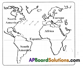
Looking at the map can you tell what the new route could be? (Conceptual understanding)
Answer:
Europe → North Atlantic Ocean → South Atlantic Ocean → the Arabian Sea →‘India.
Question 40.
Look at a globe to check whether Columbus’s thinking was correct. (Mapping skills)
Answer:
Yes, Columbus’s thinking was correct, but it takes too much time to reach India.
![]()
Question 41.
Look at Map 7 (given below) and answer the following questions.(Mapping skills)
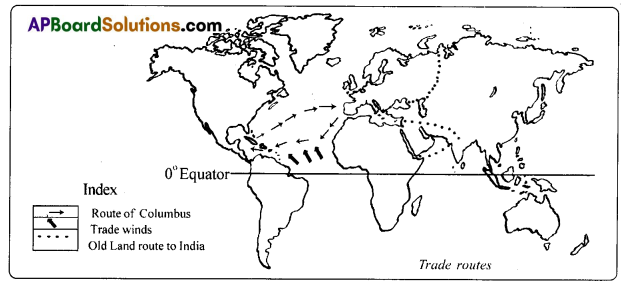
a) Which winds would help the sailors to return to Europe from America?
Answer:
The trade winds would help the sailors to return to Europe from America.
b) Could the sait-driven ships use the Trade Winds to return to Europe? Give reasons. (Conceptual understanding)
Answer:
No, the sail-driven ships using trade winds could not help to return to Europe. The trade winds blow westwards taking ships from Europe to America. These are not favourable to travel from America to reach Europe which is on east side.
Additional Questions
Question 1.
Which is longest river in Europe?
Answer:
‘Volga’ is the longest river in Europe.
Question 2.
What are ‘Peninsulas’?
Answer:
Land masses that are surrounded Lw the sea on three sides and connected to the mainland on the fourth side are called Peninsulas’.
Question 3.
Explain the term ‘Bays and Gulfs’.
Answer:
Bays and gulfs are parts of the sea endosed by land on three sides.
Question 4.
Who are known as ‘Dutch’?
Answer:
The people of Holland are known as ‘Dutch.
Question 5.
When did ‘Industrial Revolution’ started in England?
Answer:
The Industrial Revolution started in England around 1750.
Question 6.
What is ‘Mediterranean Climate’?
Answer:
The lands along the Mediterranean sea have a distinct climate is known as ‘Mediterranean Climate’.
Question 7.
Which is the second smallest continent in the world?
Answer:
Europe is the second smallest continent in the world.
![]()
Question 8.
Name the Important rivers of Europe.
Answer:
Rhine River, Volga River, Danube River and Po River.
Reading the text (given), understanding and interpretation
A. Read the passage and answer the following questions.
Industrial Revolution in Europe:
The industrial revolution as you know started in England around 1750 and soon factory production spread to France, Holland, Germany, Spain. Russia etc. Countries like England and Germany which had large rcservés of coal and other minerals took lead in developing new industries. However, as times changed, European countries began to use less and less of their own mineral resources and relied on imports from other countries. The old mining towns and old factories were closed down and new factories grew in new areas. Industrialisation also enabled the European countries to import agricultural goods from other countries.
Thus, they relied less on the agriculture of their countries for their fcwLxi and raw material requirements. Hence Europe became dependent upon trade with other countries. Initially, this trade was with their colonies in Asia, Africa and America. However as the colonies became independent, they had to develop new ways of trading with them.
Question.
Write about industrial revolution in Europe.
Answer:
- The industrial revolution started in England around 1750.
- Soon the factory production spread to France, Holland, Germany, Spain, Russia etc.
- Countries like England and Germany which had large reserves of coal lead in developing new industries.
- Industrialization enabled the European countries to import agricultural goods from other countries.
B. Read the passage and answer the following questions.
The Mediterranean countries are the southernmost countries of Europe. As a result, the winters here are not too cold and summers are warm, it does not rain all through the year as in Western Europe. The Westerlies blow here during the winter months only. These winds bring rain to the Mediterranean countries.
In other words, it rains here only in winter. Such rainy winters and dry summers are
termed as ‘Mediterranean climate’, Several regions in other continents too have a Mediterranean climate. This climate is very good for growing juicy fruits. Thus regions with Mediterranean climate are famous for their fruits. Fruits like olives, figs, grapes, oranges, etc. are grown extensively in southern Europe.
Question.
Describe Mediterranean climate.
Answer:
- In Mediterranean climate, the winters are not too cold and summers are warm.
- It does not rain all through the year as in Western Europe.
- Westerlies blow during the winter and brings rain to the Mediterranean countries.
- Such rainy winters and dry summers are termed as Mediterranean climates.
- The climate is good for growing juicy fruits.
- Fruits Like olives, figs, grapes, oranges are grown extensively in southern Europe.
Information skills
A. Europe at a glance:
| Mountains | Scandinavian mountains, Ural mountains, Alps mountains, Apennines mountains, Pyrenees mountains, Carpathian mountains, and Caucasus mountains. |
| Plains | Lombardy, Anlysiya plains, North European plains and Hungarian plains. |
| Rivers | Seine, Dnieper, Volga, Vistula, Danube, Po, and Rhine. |
| Islands | Sicily, Sardinia, Corsica, Belarica, Crete, Malta and Cyprus, U.K. |
1. Write down any two islands of Europe?
Answer:
Corsica and Sicily.
2. Name some mountains of Europe.
Answer:
Alps, Ural and Caucasus etc.
![]()
3. What is Lombardy? (A plain /A mountain)?
Answer:
A plain.
B.
| Boundaries of Europe | |
| North | Arctic Ocean |
| South | Mediterranean Sea Black sea, Caspian Sea |
| East | Ural Mountains |
| West | Atlantic ocean |
a. Name the ocean to the west of Europe.
Answer:
Atlantic.
b. Which sea in the south of Europe means ‘middle of the world’?
Answer:
Mediterranean.
C.
| Island | Land mass which is surrounded by four sides | Great Britain |
| Peninsula | Land mass which is surrounded by three sides sea | Scandinavia |
| Bay | The land curves inwards and the mouth of the sea is usually wide | Bay of Biscay |
| Gulf | A gulf is a narrow inlet of the sea and has a narrow mouth | Baltic sea |
Now, answer the following questions:
1. What is meant by gulf?
Answer:
A gulf is a narrow inlet of the sea and has a narrow mouth.
2. Is Great Britain a peninsula (or) an island?
Answer:
Great Britain is an island.
3. Write down one example for ‘bay’.
Answer:
Bay of Biscay.
4. What is a ‘peninsula’?
Answer:
Land mass which is surrounded by three sides sea.
5. What is a Bay?
Answer:
The land curves inwards and the mouth of the sea is usually wide.
Mapping skills
A. Locate the following places in the World Map. (Map Pointing)
1) Europe
2) Africa
3) Arctic ocean
4) Atlantic ocean
5) Equator
6) Australia
7) Pacific Ocean
8) Ural mountains
9) Indian Ocean
10) Asia
11) India
12) North America
13) South America
Answer:
B. Observe the following Europe map and answer the questions.
1. Write down the countries around the Black Sea.
Answer:
Bulgaria. Romania, Moldova and Ukraine.
2. Write any two islands in European Continent.
Answer:
Iceland, Ireland.
3. Which countries are also part of Scandinavian peninsula?
Answer:
Norway and Sweden.
![]()
4. Which ocean Is frozen most of the year?
Answer:
Arctic Ocean.
5. Which sea in Europe means middle of the world?
Answer:
Mediterranean sea.
6. Which sea is known as ‘Dogger Bank’?
Answer:
North sea.
7. Which ocean affects the climate of Europe?
Answer:
Atlantic ocean.
8. Name some of the Mediterranean countries.
Answer:
Portugal, Spain. Italy and Southern France.
9. In which country Industrial Revolution started in European continent?
Answer:
England.
C. Locate the following places in the given Europe map.
1) Caspian sea
2) Black sea
3) Mediterranean sea
4) Adriatic Sea
5) River Rhine
6) River Danube
7) Pvrenees mountains
8) Caucasus mountains
9) Bay of Biscay
10) Alps mountains
D. Observe the map and answer the following questions.
1. Which Is the second smallest continent?
Answer:
Europe.
2. Which is the second biggest continent?
Answer:
Africa.
3. Which is the biggest continent f
Answer:
Asia.
4. Which latitude can you find in the map?
Answer:
0° latitude that is “equator”.
E. Observe the Map and answer the following question.
Question.
What winds are indicated by arrow marks in the above map?
Answer:
Westerlies
![]()
F. Observe the map and answer the following questions.
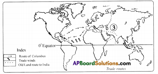
1. What is indicated by the symbol ‘→‘ in above map?
Answer:
North Atlantic Drift.
2. What is indicated by the symbol ‘↑’ in above map?
Answer:
Trade winds.
3. What is indicated by no ‘3’ in above map?
Answer:
Old land route to India.
Work Book
Question 1.
Industrial revolution took place first in ………………… continent. ( )
A) Africa
B) Europe
C) Asia
Answer:
B) Europe
Question 2.
…………………….. sea separates Europe in the north from Africa in the south. ( )
A) Mediterranean sea
B) Black sea
C) Caspian sea
Answer:
A) Mediterranean sea
Question 3.
…………………. and ……………… are one continuous landmass. ( )
A) North America and South America
B) Europe and Africa
C) Asia and Europe
Answer:
C) Asia and Europe
Question 4.
……… mountain ranges in Europe are covered with snow all the year round. ( )
A) Ural
B) Alps
C) Caucasus
Answer:
B) Alps
Question 5.
Caucasus Mountains lie between ( )
A) Caspian and Black Sea
B) Mediterranean and Black Sea
C) aspian and Adriatic sea
Answer:
A) Caspian and Black Sea
Question 6.
Norway and Sweden are a part of a peninsula. It is known as ( )
A) Kola peninsula
B) Scandinavian peninsula
C) Ionian peninsula
Answer:
B) Scandinavian peninsula
![]()
Question 7.
Bays and gulfs are parts of the sea enclosed by land on …………….. sides. ( )
A) one
B) two
C) three
Answer:
C) three
Question 8.
In Europe, if Poland has severe winter France has ( )
A) winter climate
B) rainy climate
C) warmer climate
Answer:
A) winter climate
Question 9.
The Westerlies blow from the Atlantic Ocean towards Europe ( )
A) in winter
B) in summer
C) all round the year
Answer:
C) all round the year
Question 10.
………………………. ocean is frozen most of the year in Europe. ( )
A) Arctic ocean
B) Atlantic
C) Indian
D) Pacific
Answer:
A) Arctic ocean
Question 11.
……………………. mountains are there in the east of the Europe. ( )
A) Himalayas
B) Ural
C) Alps
D) Rockies
Answer:
A) Himalayas
Question 12.
………………………… is the longest river in Europe. ( )
A) Danube
B) Indus
C) Volga
D) Tiber
Answer:
C) Volga
![]()
Question 13.
Rhine and Volga drain into ………………… sea. ( )
A) Black sea
B) Caspian sea
C) Rea sea
D) Arabian sea
Answer:
B) Caspian sea
Question 14.
Biggest country in Europe ( )
A) Austria
B) U.K.
C) Russia
D) Vatican City
Answer:
C) Russia
Question 15.
Columbus set out with three ships in ………………… to cross Atlantic oceans ( )
A) 1592
B) 1492
C) 1692
D) 1392
Answer:
B) 1492
Question 16.
………………………. sea is called middle of the world ( )
A) Black
B) Red
C) Mediterranean
D) Arabian
Answer:
C) Mediterranean
Question 17.
Asia and Europe are one continuous landmass which is called ………………… . ( )
A) U.K.
B) C.I.S.
C) Eurasia
D) Asia – Europe
Answer:
C) Eurasia
Question 18.
…………………. is the southernmost country In Europe ( )
A) Switzerland
B) France
C) Germany
D) Holland
Answer:
Question 19.
…………………… are used for making wine ( )
A) Oranges
B) Grapes
C) Pineapples
D) Sugar beet
Answer:
B) Grapes
Question 20.
Europeans did not know of …………………. before Columbus ( )
A) Australia
B) India
C) America
D) Austria
Answer:
C) America
Question 21.
Regions with Mediterranean climate are famous for their …………………… . ( )
A) forests
B) wheat
C) fruits
D) grass
Answer:
A) forests
Question 22.
Industrial revolution was started in …………………. . ( )
A) England
B) Russia
C) America
D) Switzerland
Answer:
A) England
Question 23.
Which countries are on the shores of the Arctic Ocean? ( )
A) Norway
B) Sweeden
C) Both A & B
D) None of these
Answer:
C) Both A & B
![]()
Question 24.
……………………. is an international river. ( )
A) Rhine
B) Danube
C) Volga
D) Tiber
Answer:
B) Danube
Question 25.
The Gulf Stream flows in the …………………… . ( )
A) Atlantic ocean
B) Mediterranean sea
C) Black sea
D) Red sea
Answer:
A) Atlantic ocean
Question 26.
Westerlies are ………………… . ( )
A) Wet
B) Dry
C) Moist
D) Pressure
Answer:
D) Pressure
Question 27.
The mountains that lie between the Caspian Sea and the Black Sea are ( )
A) Himalayas
B) Caucasus
C) Ural
D) Alps
Answer:
B) Caucasus
Question 28.
The bay adjacent to Pyrenees mountains ( )
A) Alps
B) Bay of Biscay
C) River Rhine hay
D) Caucasus Bay
Answer:
B) Bay of Biscay
Question 29.
What winds are indicated by arrow marks in the above map?
A) Monsoon winds
B) Typhoons
C) Easterlies
D) Westerlies
Answer:
D) Westerlies
![]()
Question 30.
………………….. climate is very good for growing juicy fruits.
A) Maritime
B) Mediterranean
C) Continental
Answer:
B) Mediterranean
Question 31.
The people of Holland overcame the problem of shortage of land.
A) by removing forests
B) by reclaiming land from the sea by building
C) by transferring soil
D) by removing mountains
Answer:
B) by reclaiming land from the sea by building