Telangana SCERT 7th Class Social Guide Pdf Telangana 2nd Lesson Rain and Rivers Textbook Questions and Answers.
TS 7th Class Social 2nd Lesson Questions and Answers – Rain and Rivers
Improve Your Learning
Question 1.
Explain how water changes into water- our and how clouds are formed from it?
Answer:
- As the water heated up, water – vapour is formed.
- Water – vapour mixes with the air through a process called evaporation.
- When water vapour rises with hot air and reaches high up in the sky, it gets cooled.
- With the cooling water vapour is transformed into tiny water droplets.
- These droplets gather around minute dust or smoke particles in the air and gradually increase in size.
- These small drops of water gather to form the clouds.
Question 2.
Where do evaporation and cloud formation take place on a large scale?
Answer:
The maximum evaporation and cloud formation take place on the surface of the oceans.
Question 3.
How do the clouds reach deep inland?
Answer:
Clouds rise upwards and get cooler and more droplets are formed. The droplets get together to form bigger drops. As they get heavier, it gets more and more difficult for them to remain in the air and so they begin to fall as raindrops on deep inland.
Question 4.
Where does it rain the most? Choose the correct option.
Answer:
- Sea coasts that are in the direction of the winds.
- Mountains that are in the direction of the winds.
- Lands far away from the seas.
Question 5.
Fill in the blanks choosing the correct options.
(bank, tributaries, flood – plain, river valley)
Answer:
a) A river flows through the ………………….. . (river valley and river courses)
b) Streams or rivers Joining a larger river are called the ………………. of the main river. (tributaries)
c) The entire valley of a river which is filled with water during the floods is called the …………………. of the river. (flood, plain)
![]()
Question 6.
The Godavari flows from the west to the east. Why?
Answer:
- The entire peninsula is tilted towards east.
- The Godavari originates in Western Ghats at Triyambakam near Nasik in Maharashtra.
- This land also tilted towards southeast.
- So, the river Godavari flows towards east and joins the Bay of Bengal.
Question 7.
Describe the main stages of the water cycle
Answer:
The main stages of the water cycle are:
- Water evaporating from the seas, rivers and other water surfaces.
- Formation of clouds in the sky.
- Condensation
- Precipitation
- Joining the sea again.
Question 8.
There may be streams and rivers flowing near your village or town. Find out about them and fill in the table below?
| Name | Source | Which river does it join? | Which sea does it meet? |
Answer:
| Name | Source | Which river does it join? | Which sea does it meet? |
| 1. Godavari | Western Ghats | – | Bay of Bengal |
| 2. Krishna | Western Ghats | – | Bay of Bengal |
| 3. Kinnerasani | Tadwai Hills, Madaram in Warangal district | Godavari | Bay of Bengal |
| 4. Munneru | Pakala tank,Warangal district | Krishna | Bay of Bengal |
Question 9.
Do the rivers in your area contain water throughout the year? Find out from your elders if they had more water in earlier times.
Answer:
No, the river Godavari in our area does not contain water throughout the year. In earlier times, it had more water as there was not much use of water as of nowadays.
Question 10.
How can the people be prepared to face the disasters?
Answer:
- During disasters the people have to listen to radio or TV weather reports.
- They have to keep an emergency kit ready at home.
- The rescue place should be identified well in advance.
- During cyclones, they have to store drinking water and food grains in water proof bags.
- They have to move to a pucca building if their house is not strong enough.
- They have to keep themselves away from the seashore, trees, electric poles that may be uprooted during the gale.
- They should not venture to go out of the house or a safe place.
Question 11.
Collect the pictures showing cyclones and floods and prepare an album.
Answer:
Students activity.
Question 12.
Make a poster on the floods devastation.
Answer:
Student’s activity.
![]()
Intext Questions
Text Book Page No. 8
Question 1.
In which season would be more evaporation – summer or winter? (Conceptual understanding)
Answer:
Summer.
Question 2.
When will the evaporation be more, during the day or night? (C.U.)
Answer:
I think there is mere evaporation during the day.
Question 3.
Look at figure and make list of all places from where evaporation happens. (Mapping skills)
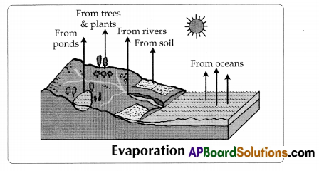
Answer:
a) Pends
b) Rivers
c) Oceans
d) Trees and plants
e) Soils
Question 4.
Where do you think would maximum evaporation would lake place – from plants, rivers, oceans or soils? (Conceptual understanding)
Answer:
The maximum evaporation would take place from oceans.
Question 5.
Make a diagram to explain how vapour is transformed into clouds. Label your diagram with these terms. Earth, sky, rising vapour, dust particles, water droplets, clouds …………. . (Mapping skills)
Answer:
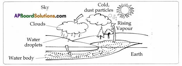
Text Book Page No.9 & 10
Question 6.
Why do you think it is necessary for the clouds to rise in order to cause rain?
Answer:
The clouds continue to rise upwards. It gets cooler and droplets are formed in order to rain.
Question 7.
Have you ever observed dew? Where is it formed?
Answer:
Yes, it is formed on cool surfaces of leaves, grass etc.
8. In which part of the day will you find fog?
Answer:
In the morning part of the day.
9. In which season do we have more foggy days?
Answer:
In winter season.
Question 10.
Have you ever seen snowfall? How is it different from rainfall?
Answer:
- Yes. I saw snowfall when I scent to Shimla.
- If the precipitation is in the form of drops of water, it is called rainfall.
- The precipitation in the form of snowflakes is called the snowfall.
Question 11.
Have you ever experienced hail storm?
Answer:
Yes. I have experienced hail storm during last summer.
Question 12.
From which direction does the wind blow during the rainy season?
Answer:
Winds blow in the southwest direction.
![]()
Text Book Page No.11
Mapping skills
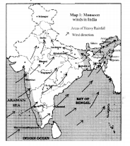
Question 13.
Towards which paris of the country would the winds take the clouds from the Bay of Bengal?
Answer:
To North – Fast part of the country.
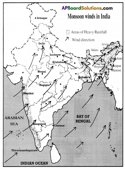
Question 14.
Towards which parts of the country would the winds take the clouds from the Arabian sea?
Answer:
Kerala, Karnataka, Maharashtra, Madhya Pradesh, Chattisghad. Tamilnadu and Goa.
Question 15.
From which direction would the winds blow to bring monsoon rains to West Bengal, Lucknow and Delhi?
Answer:
From South to North East and
North – East to North.
Question 16.
From which direction would the winds blow to bring monsoon rains to Mumbai, Hyderabad and Bangalore?
Answer:
South-West to north and east.
Rainfall In Telangana
Question 17.
In which months, does it rain most in your place? List three rainiest months.
Answer:
October, November, December.
Question 18.
Name the three driest months.
Answer:
January, February and March are the driest months.
Question 19.
Do you have normal’ rainfall every year or does ¡t vary every year?
Answer:
- Generally, we receive normal rainfall every year.
- Sometimes the rainfall may be less than the normal rainfall. Then we experience drought.
- Sometimes we experience heavy rainfall which may cause floods.
Question 20.
Have you ever experienced drought?
Answer:
Our region receives abundant rainfall hence we never experienced drought.
Question 21.
Have you ever experienced floods?
Answer:
No. I have never experienced floods. But I heard about Diviseerna floods. Recent floods of October 2013 are very severe. I watched on TVs.
Question 21A.
10 Years Rainfall in Sirsilla town:
| Year | Rainfall in M.M | Year | Rainfall in M.M |
| 1996 | 933 | 2001 | 763 |
| 1997 | 695 | 2002 | 605 |
| 1998 | 926 | 2003 | 819 |
| 1999 | 823 | 2004 | 619 |
| 2000 | 895 | 2005 | 891 |
Source: tahsildar office, Sirsilla
a. What is the average rainfall of Sirsilla town?
Answer:
The average rainfall of Sirisilla town is 796 M.M.
b. Observe the above data. In which year did Sirsilla receive the highest and the lowest rainfall?
Answer:
According to the above data Sirisilla received highest rainfall in 1996 and lowest rainfall in 2002.
c. During which Iwo years did ¡t get high rainfall?
Answer:
During 1996 and 1998 Sirisilla got high rainfall.
![]()
Text Book Page No. 12
Question 22.
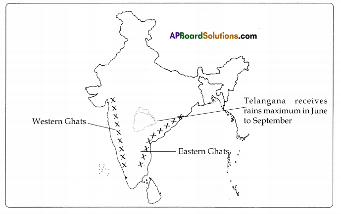
Look at the map given below showing rainfall received in different parts of Telangana. (Mapping skills)
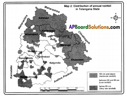
i) Does your district receive heavy, moderate or low rainfall?
Answer:
Moderate,
Note: Students are advised to write about their own district …………. .
ii) Which town has the least highest rainfall – Nalgonda, Mahahub Nagar, Adilabad, Khammam, Hyderabad?
Answer:
- High rainfall towns: Adilabad, Khammam
- Least rainfall towns: Nalgonda. Mahabub Nagar, Hyderabad.
Question 23.
Look at the physical map of India in your Atlas and identify Western Ghats, Eastern Ghats. (Mapping skills)
Answer:
Fill in the blanks in the following sentences. (Map Reading)
Western Ghats are spread across the following states ………………….,………………,……….
Answer:
Gujarat, Maharashtra, Karnataka. Kerala etc.,
Eastern Chats are spread across following ………………….,………………,……….
Answer:
Tamilnadu, Andhra Pradesh, Odissa’etc.,
In which region do Western and Eastern ghats intersect?
Answer:
The Western and the Eastern ghats intersect at Nilgiris.
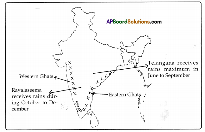
First create rough oullines of India in a notebook; then draw Western Chats and Eastern Chats; After thai, roughly mark the areas of Telangana. Finally, label them with months in which it rains.
Answer:
Text Book Page No. 14
Study the figure below and answer these questions.
Question 24.
Mark the flow of the river with arrows.
Answer:
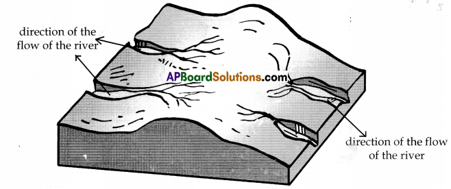
b. Mark the slope of the land with arrows.
Answer:
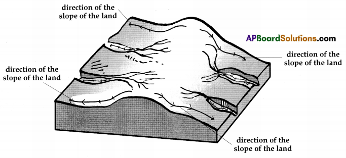
c. Does the river flow in the same direction as that of the slope of the land?
Answer:
Yes. The rivers flow in the same direction as that of the slope of the land except a few who fall on the fault line and flow in the other direction.
![]()
Text Book Page No. 15 And 16.
1. Make a list of important streams in your district and identify the major river it joins.
Answer:
table
2. Mark whether the stream in your district flows round the year or only during rainy
season.
Answer:
Students Activity.
3. What do you think is the direction of the slope in Telangana map? From north to south, east to west or west to east?
Answer:
The direction slope in Telangana map is from west to east. So the rivers which flow from west to east.
Question 27.
The following figure (2.5) depicts a flood situation.
Look at it carefully and answer the following questions: (Mapping skills)
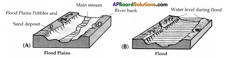
a. Has the river water covered the entire flood•plain or confined to the tiny stream that was flowing in the dry season?
Answer:
The river water covered the entire flood – plain.
b. Is the water confined to the flood. plain or overflown the banks of the river?
Answer:
The water has overflown the banks of the river.
c. In what way have the floods affected the villages, agricultural fields and trees?
Answer:
a) Low-lying areas are inundated b floods.
b) Agricultural lands and crops are damaged.
c) Villages and towns may be drowned.
d) Heavy losses of wealth and human lives are caused.
e) Roads and trees, power and telephone lines will be interrupted.
d. How are floods beneficial to agricultural fields?
Answer:
1) During floods the rivers bring the fertile alluvial soil.
2) After the flood water recedes, they deposit that fertile alluvial soil on the banks of the rivers.
3) This soil is very beneficial to agricultural fields for growing certain crops or fruits.
Text Book Page No. 17
Question 28.
Can you explain how forests and vegetation can help in preventing floods?
Answer:
a) Vegetation cover on the land obstructs the runoff of rainwater and slows down the speed of its flow.
b) Vegetation allows the water to flow 5lowly into the river to prevent sudden flooding
c) It reduces the erosion of soil by rainwater which reduces the depth of the river.
d) Forests reduce the rainwater that rapidly flows down the slopes of the mountains and falls up the flood plain of the river.
So, we must protect our forests and increase the vegetation cover over other lands to prevent floods.
Question 29.
Can forests and vegetation help in reducing droughts? How?
Answer:
Yes, forests and vegetation help in lessening the effects of droughts. Vegetation covers on the land obstructs the run off of rain water and slows down the speed of its flow. Forests reduce the rain water that rapids flows down the slopes of the mountains and falls up the flood plain of the river.
Additional Questions
Question 1.
How can the people prepare for disasters?
Answer:
- Cyclones and floods are a seasonal phenomenon. During cyclone, people listen to radio or TV weather reports and in case of a cyclone/flood warning, they ensure that everyone is alerted. This is usually done through loudspeakers or by going from door to door.
- Keep an emergency kit ready at home. These kits should contain important papers and some food materials and currency. Information about important telephone numbers that may have to be contacted during emergency should also be stored in the kit.
- The nearest available place where refuge could be sought in case of a cyclone, should be identified in advance.
- Where necessary, the walls of the house, roofing, doors and windows should be strengthened.
- When you get a cyclone warning, store adequate drinking water and food grains in waterproof bags.
- Do not venture outside, especially into the sea during and after the warning has been sounded.
- Close doors and windows and stay indoors.
- Move to a pucca building if you feel your house is too weak to withstand even an ordinary upsurge.
- If the cyclone strikes while you are in a vehicle, stop but keep away from the seashore, trees, electric poles and other objects that may be uprooted during the gale.
- If the cyclone wind suddenly drops, do not venture out, as this could be the eye of the cyclone. Wait till a clear declaration is made officially.
- Heed to such advice as may be coming through Radio broadcasts.
- Even after safety has been sounded take necessary precautions while moving to or out of your house. There may be partially uprooted trees or poles.
- Look out for snakes that may have come out of their holes.
- Do not enter flood waters. They may be too deep.
- As a student group you can play a very significant role in spreading awareness about the above precautions.
Question 2.
If you need to evacuate in disasters what are the precautions required?
Answer:
- Pack clothing, essential medication, valuables, personal papers etc., in waterproof bags, to be taken to the safe shelter.
- Raise furniture, clothing, appliances on to beds or tables (electrical items highest).
- Turn off power.
- Whether you leave or stay, put sandbags in the toilet bowl and cover all drain holes to prevent sewage back-flow.
- Lock your house and take the recommended or known evacuation routes from your area to the safe shelter.
- Do not get into water of unknown depth and current.
![]()
Question 3.
How to prepare the people during floods?
Answer:
- Drink boiled water.
- Keep your food covered, don’t cat heavy meals.
- Use raw tea, rice, water, tender coconut water etc., during diarrhoea.
- Do not let children remain on empty stomach.
- Use bleaching powder and lime to disinfect the surroundings.
- Avoid entering floodwaters. If you have to enter, wear proper protection for your feet and check depth and current with a stick. Stay away from water over knee-deep depths.
- Do not eat food that has got wet in the flood waters.
- Boil tap water before drinking in rural areas. Use halogen tablets to purify water before drinking (ask Village Health Workers for details).
- Be careful of snakes. Snake bites are common during floods.
Question 4.
How do you measure rainfall?
Answer:
- The instrument known as rain gauges is used to measure rainfall.
- The amount of rainfall for a limit area is measured in centimetres.
Question 5.
Normally when do the cyclones and floods occur?
Answer:
Cyclones and floods usually occur between June and December.
Question 6.
Can you explain the causes of devastating floods? In what way it Is natural occurrence and in what way it is man-made? (Reflection on contemporary issues and questioning)
Answer:
The natural cause of devastating floods is unexpected excess rainfall due to cyclones.
The man-made causes of devastating floods are
1) the destruction of vegetation cover on the land and the forests
2) use of plastic which obstructs flow of water.
Two Marks Questions
Question 1.
What is meant by evaporation?
Answer:
Change of water into vapour known as evaporation.
Question 2.
What is meant by precipitation?
Answer:
Different forms of condensation of water vapour is known as precipitation.
Question 3.
What is meant by humidity?
Answer:
The amount of invisible water vapour present m the atmosphere is known as humidity.
Question 4.
Which are called Monsoon winds or South – West Monsoon winds?
Answer:
The winds which come all the way from the Arabian Sea and the Bay of Bengal called Monsoon Winds.
Question 5.
What is a cyclonic rain?
Answer:
Rain caused by whirling storms is called cyclonic rain.
Question 6.
What are tributaries?
Answer:
Rivers or streams which join a larger river are called ‘tributaries.”
Question 7.
During which season will the Telangana districts receive much rainfall?
Answer:
The Telangana districts receive much rainfall during South-West Monsoon season.
![]()
Question 8.
When do the Northeast Monsoons blow from?
Answer:
The northeast monsoons blow from October-December.
Question 9.
During which season will the coastal regions receive much rainfall?
Answer:
During the North-East Monsoon season, the coastal regions receive much rainfall.
Question 10.
How do we measure rainfall?
Answer:
We measure rainfall with an instrument called rain guage.
Reading the text (given), understanding and interpretation
A. Read the passage and answer the following questions.
The direction of the winds reverses after October as the winds begin to blow from the Bay of Bengal towards South West. This causes very little rains in October and Novembers in Telangana region. This is called North East Monsoons or the Retreating Monsoon.
Write about Northeast Monsoon season.
Answer:
- The direction of the winds reverse after October.
- These winds blow from North-F.ast direction to South West.
- They cause very little rains in October and November in Telangana region.
- These are called North-Fast monsoons.
Information Skills
(A) Read the passage and answer the following questions.
The mountain ranges like the Western Ghals in the path of rain-bearing winds and causes them to rise. Rising air cools down and water vapour condenses faster. Further, ascent leads to rainfall. This type of rainfall is common in the mountain our regions.
From May to October, cyclones form in the Bay of Bengal. These cyclones may or may not bring rain to one region. It depends upon the intensity of the cyclone in the Bay of Bengal and the direction of the cyclone after crossing the coast.
1. Name range that is mentioned in the passage.
Answer:
The Western Chats.
2. What happens when air rise?
Answer:
Rising air cools down and water vapour condenses faster.
3. During which months do cyclones form in Bay of Bengal?
Answer:
May to October.
![]()
4. Does cyclones form in Bay of Bengal bring rain in our region?
Answer:
These cyclones may or may not bring rain to our region. It depends upon the intensity of the cyclone in the Bay of Bengal and the direction of the cyclone after crossing the coast.
5. When do the winds generally rise?
Answer:
The mountain ranges in the path of rain bearing wind cause them to rise.
(i) Read the passage and answer the following questions.
Humidity: The amount of invisible water vapours present in the atmosphere is known as humidity. When temperature and humidity are high. we feel uncomfortable. We perspire and the sweat does not evaporate quickly. We feel sticky and such weather is called sultry.
Evaporation: Change of water into vapours is known as evaporation. The process in which water vapour changes into water is called condensation. Clouds are tiny droplets of water hanging in the air above.
Precipitation: Different forms of condensation of water vapours is known as precipitation. This may take place in the form of dew, fog, rain; snow, or hail etc.
1. What is humidity?
Answer:
The amount of water vapours present in the air.
2. When do we feel uncomfortable?
Answer:
When temperature and humidity are high.
3. What is evaporation?
Answer:
Change of water into vapours is known as evaporation.
4. What is condensation?
Answer:
The process in which water vapour changes into water is condensation.
5. Name some forms of precipitation.
Answer:
Dew, fog, rain, snow, hail etc.
Reflection on contemporary issues and questioning
Question 1.
‘The agricultural prosperity of a region very much depends on the rivers and rains. How can you say?
Answer:
- Water and rivers are essential for the agricultural progress of a region.
- The availability of irrigation and water supply very much depends upon the rivers that flow throughout the year.
- Rivers not only develop agriculture but also provide many other benefits like power generation, and afforestation. soil conservation, tourism, fishing etc.,
Question 2.
How are forests and vegetation helpful in preventing floods?
Answer:
- Vegetation cover on the land obstructs the runoff of rainwater and flows down the speed of its flow.
- This helps the rainwater to percolate into the soil.
- Hoods are often caused by sudden increase in the value of water reaching a river.
- If the surface of the land is covered with vegetation, the soil erosion is greatly reduced.
- In the recent years there has been a large-scale felling of trees and hence the forest cover in the Himalayas has been reduced considerably.
- As a result, whenever there is heavy rain, the rainwater rapidly flows down the slopes of the mountains and fills up the flood plains of the river. This result in frequent floods which cause heavy damage to life and property along the river.
Appreciation and Sensitivity
Question 1.
What are the immediate damage of the cyclones? (Conceptual Understanding)
Answer:
These are heavy – like loss of lives, crops, houses etc.
Question 2.
What are the long-term damages of the cyclone? (Conceptual Understanding)
Answer:
- The life savings of most of the poor. stored in houses in the form of food, tools, small shops, vehicles, boats, nets etc., are damaged.
- Many families may lose their working members.
- Daily wage workers face loss of work for several days till normalcy returns and thus lose their livelihood.
- Farmers not only face loss of crops but also permanent damage to their lands.
![]()
Question 3.
How do governments meet the challenges of disasters like cyclones and floods? (Appreciation and Sensitivity)
Answer:
- Government has to prepare a long-term planning in close cooperation between people and government agencies.
- The governments have to predict considerably in advance the possibilities of natural disasters like cyclones and floods particularly regions that are most vulnerable, For this, they have to set up sell equipped meteorology bureau.
- Government has to build strong roads which are not easily damaged.
- Pucca houses are to be built for those living in vulnerable areas like sea coast or along the rivers or in low lands,
- Food, water and medical emergency teams should be kept ready whenever there is a forecast of cyclones.
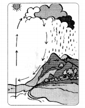
Question 5.
What does the given figure show.
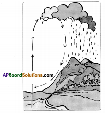
Answer:
The above picture depicts “the water cycle.”
Mapping Skills
Question 1.
Look at the Physical Map of India and identify Western Chats, Eastern Chats. (Mapping skills)
Answer:
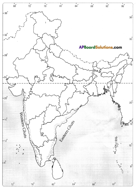
a. Name the states that the Western Chats are spread across.
Answer:
Gujarat, Maharashtra, Kamataka, Kerala etc.,
b. Name the states that the Eastern Chats are spread across.
Answer:
Tamilnadu, Andhra Pradesh, Odissa etc.,
c. In which direction of Telangana are Western Chats are situated?
Answer:
West
Question 2.
Locate the following in the outline map of the Telangana.
a) River Godavari
b) River Krishna
C) River Musi
d) Manjeera
e) Thungabhadra
Answer:
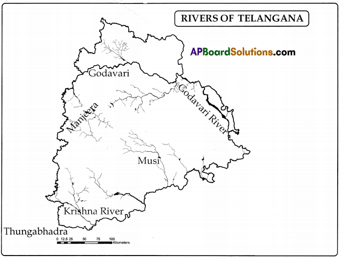
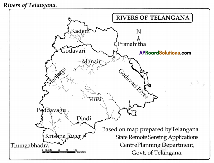
Question 3.
took at the Rivers of Telangana map given in Page 24 and answer the following
questions.
a. What are the tributaries of Krishna river?
Answer:
Dindi, Thungabhadra, Musi.
b. In what big river does Pranahitha merge?
Answer:
The Godavari.
c. In what sea does Krishna River merge?
Answer:
Bay of Bengal.
d. What is the river that flow in the Khanimani district?
Answer:
Godavari.
Workbook
Question 1.
The surface of earth covered with water ( )
A) 60%
B) 71%
C) 50%
D) 80%
Answer:
B) 71%
Question 2.
Change of water into vapour is called ( )
A) Humidity
B) Precipitation
C) Evaporation
D) Rain
Answer:
C) Evaporation
![]()
Question 3.
Rain caused by whirling storms is called ( )
A) Conventional rain
B) Cyclonic rain
C) Relief rain
D) None of the above
Answer:
D) None of the above
Question 4.
Which of the following is Perennial river? ( )
A) Penna
B) Kaveri
C) Godavari
D) Tungahhadra
Answer:
D) Tungahhadra
Question 5.
In the following months cyclones form in the Bay of Bengal ( )
A) June to August
B) May to October
C) May to September
D) July to November
Answer:
B) May to October
Question 6.
The fall of moisture is known as ( )
A) Precipitation
B) Rainfall
C) Hail
D) None
Answer:
A) Precipitation
Question 7.
Falling of big drops of water from the clouds is known as ( )
A) Humidity
B) Rain
C) Hail
D) Fog
Answer:
B) Rain
Question 8.
The river Godavari originates at ( )
A) Triyambakam
B) Mahahaleswar
C) Varaba hills
D) Nandi Durga hills
Answer:
A) Triyambakam
![]()
Question 9.
The river Krishna originates near ( )
A) Nasik
B) Nagarjuna Sagar
C) Varaba hills
D) Mahabaleshwar
Answer:
D) Mahabaleshwar
Question 10.
The process of evaporation speeds up with increase in ……………………… . ( )
A) rain
B) temperature
C) humidity
D) snowfall
Answer:
B) temperature
Question 11.
With the cooling, water vapour is transformed into …………………. . ( )
A) snow
B) water
C) moist
D) gas
Answer:
B) water
Question 12.
…………………. are vast water bodies extending up to thousands of kilometers. ( )
A) Oceans
B) Tanks
C) Rivers
D) lakes
Answer:
A) Oceans
Question 13.
North-East Monsoon is also known as ……………….. . ( )
A) South-West monsoons
B) Retreating monsoons
C) Reversal monsoons
D) Great monsoons
Answer:
B) Retreating monsoons
Question 14.
Rainfall is measured by ………………… . ( )
A) wind wave
B) Metre gauge
C) Rain gauge
D) Speedo metre
Answer:
C) Rain gauge
Question 15.
Rivers and streams which join a large river are ……………….. . ( )
A) Tributaries
B) distributaries
C) small rivers
D) small streams
Answer:
A) Tributaries
Question 16.
We feel sticky and such weather is called ………………… . ( )
A) sunny
B) sticky
C) sultry
D) Excessive
Answer:
B) sticky
Question 17.
The …………………….. of the air is closely related to its temperature. ( )
A) water vapour
B) Humidity
C) Atmospheric pressure
D) Rainfall
Answer:
C) Atmospheric pressure
![]()
Question 18.
Rain caused by whirling storms is called …………………….. . ( )
A) Typhoon
B) earthquake
C) Tsunami
D) Cyclonic rain
Answer:
D) Cyclonic rain
Question 19.
The direction of the winds reverse in the months after ……………… . ( )
A) January
B) October
C) June
D) December
Answer:
C) June
Question 20.
The tireless bed of river is called …………… . ( )
A) Flood – Plain
B) Coast
C) Beach
D) River – Plains
Answer:
A) Flood – Plain
Question 21.
The small drops of water gather to form …………………. . ( )
A) clouds
B) cyclone
C) rain
D) water vapour
Answer:
Question 22.
The process of water evaporations, condensations and precipitation together is called as …………………….. . ( )
A) Humidity
B) Water cycle
C) Precipitation
D) Evaporation
Answer:
B) Water cycle
Question 23.
The winds coming from the Arabian Sea and the Kay of Bengal and transporting rain are called ……………….. . ( )
A) cyclones
B) tsunami
C) monsoon
D) winds
Answer:
C) monsoon
Question 24.
Which of the following is not the tributary of Godavari? ( )
A) Pranahita
B) Manjeera
C) Manair
D) Tungabhadra
Answer:
D) Tungabhadra
Question 25.
Where does the southwest monsoon enter India? ( )
A) Andhra Pradesh
B) Telangana
C) Kerala
D) Madhya Pradesh
Answer:
C) Kerala
![]()
Question 26.
What does the picture shown? ( )
A) Trade winds
B) Cyclone
C) Evaporate
D) Water cycle
Answer:
A) Trade winds