Telangana SCERT 7th Class Social Guide Pdf Telangana 1st Lesson Reading Maps of Different Kinds Textbook Questions and Answers.
TS 7th Class Social 1st Lesson Questions and Answers – Reading Maps of Different Kinds
Improve Your Learning
Question 1.
Why are the levels of all the seas equal in the world?
Answer:
Since all seas in the world are connected to each other, the levels of all the seas all over the world are roughly the same.
Question 2.
How is the sea level measured?
Answer:
- There are high tides and low tides on the level of the sea, and they never stand still.
- As a result of this phenomenon, the level of the sea keeps on either rising or falling.
- The level of the sea is carefully measured at frequent intervals and the mean level of the sea is calculated.
- Over a period of time, scientists observe the high and low levels of the sea and they calculate average level which is known as Mean Sea Level (MS.L.)
Question 3.
What are the uses of maps showing height?
Answer:
- Maps showing height help us to understand the nature of the terrain, where the mountains are, where the valleys are etc. For example: If you look at the physical map of Telangana, you can identify the Godavari slopes in the Eastern part.
- Maps showing height are very essential to construct roads or dams.
Question 4.
What differences do you find between the lifestyle of people living on high altitudes and low altitudes?
Answer:
| The lifestyle of people living in high altitudes | The lifestyle of people living in low altitudes |
| 1.Road, rail transport are available. | 1. Very difficult to construct either road or rail transport. |
| 2. People are civilized. | 2. People are less civilized. |
| 3. Telephone and communication facilities will be there. | 3. Less chance for telephone and communication facilities. |
| 4. Welfare facilities like health and education can be provided. | 4. Difficult to provide health and educational facilities. |
| 5. All crops are grown here.
|
5. Here people follow shifting cultivation and can grow only few crops. |
![]()
Question 5.
How are maps helpful to people?
Answer:
- Maps are helpful to know where the mountains are, where the valleys are, and to understand the nature of the terrain etc.
- Maps are essential when roads or dams have to be constructed.
- Maps are useful to study and understand the geographical conditions of any place.
- Historical maps are useful to know the history of any country through ages.
- Political maps tell us the boundaries of the continents, countries, states, and districts, etc.
- Maps help to identify the places and their routes.
Question 6.
Read the para Contour Lines’ of page 5 and comment on it.
Contour Lines:
A contour is a line joining the places with equal heights. On the map of Nimpur, you would have seen that there is a line passing through the village, this is the 50-meter contour line. All places on this line will have the same height of 50 meters, Contour lines will be in irregular shape depending upon the landform. These cannot cut with each other.
The distance between two contour lines will depend upon the landscape. If the laud has a steep climb then tile contour lines will be near to each other, if the slope of tile land is gentle, then the contour lines will be quite far from each other.
Answer:
- A contour is a line joining the places with equal heights.
- Contour lines will be in irregular shape.
- They cannot cut with each other.
- The distance between two contour lines will depend upon the landscape.
- If the land has a steep climb, then the contour lines will be near to each other.
- If the slope of the land is gentle, then the contour lines will be quite far from each other
Question 7.
Observe the Telangana map given above and list out the districts which are below 150 MSL.
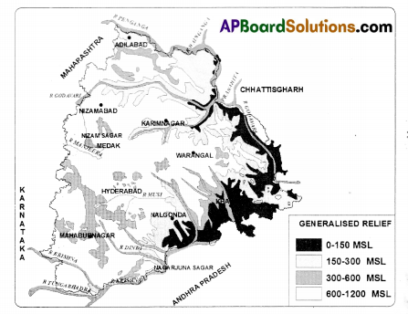
Answer:
The following districts are below 150 MSL in given Telangana sea level map.
- Nalgonda
- Khammam
- Warangal.
Intext Questions
Text Book Page No. 2
Question 1.
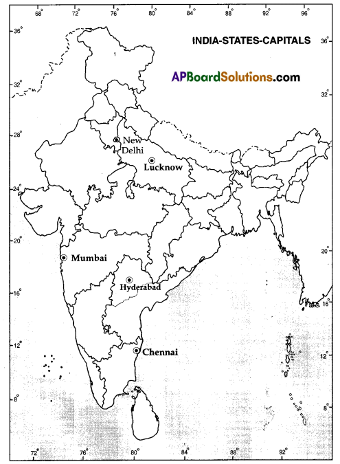
Hang a wall map of India in the class. Look at the map carefully and answer the following questions. (Mapping skills)
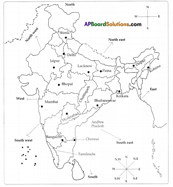
i) Mehar went to Bhopal from Hyderabad. In which direction did he travel?
Answer:
Northwards.
ii) Ashok went to Chennai from Lucknow, In which direction did he travel?
Answer:
Southwards.
iii) Regina went to Bhubaneswar from Mumbai. In which direction did she travel?
Answer:
Eastwards.
iv) Weprechu went to Jaipur from Kohima. In which direction did he travel?
Answer:
Westwards.
![]()
Question 2.
Draw the symbol for boundary of a state and symbol for the boundary of India (International boundary) in your notebook.
Answer:
The boundary of a state is shown in light blue. The boundary of India is shown with dark line.
Question 3.
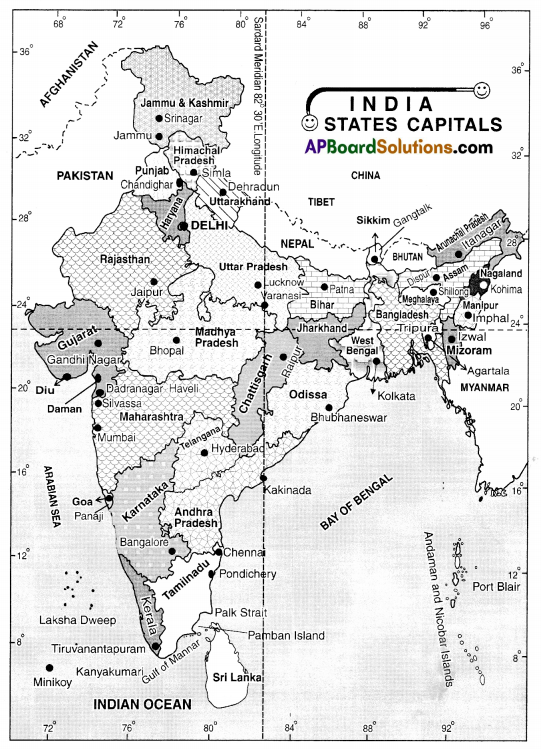
Can you make a list of states which lie to the North, South, West of Telangana? What lies to the East of the state? (Mapping skills)
Answer:
North → Maharashtra
South → Andhra Pradesh
West → Karnataka
East → Chattisgarh
Question 4.
In class VI you have learnt to measure distances between places with the help of the ‘scale’ given in the map. Now try to find out the distance between Hyderabad and various state capitals like Jaipur, Imphal, Gandhinagar, and Thiruvananthapuram.
Answer:
The relationship between a distance on the map and corresponding distance on the ground is shown with the help of the Scale’.
For example. 1 centimeter = 200 kilometers
i) The distance between Hyderabad and Jaipur is 6 cm.
6 cm x 200 km = 1200 km.
ii) The distance between Hyderabad and Imphal is 9 cm.
9 x 200 km = 1800 km.
iii) The distance between Hyderabad and Gandhinagar is 5 cm.
5 cm x 200 km = 1000 km.
iv) The distance between Hyderabad and Thiruvananthapuram is 5.5 cm.
5 ½ cm X 200 km = 1100 km.
Question 5.
Look at a few maps in later chapters of this book and list out the objects in the given map in the following table:
| Point Symbol | Line Symbol | Area Symbol |
| 1. Delhi | 1. River | 1. Playground |
| 2. | 2. | 2. |
| 3. | 3. | 3. |
Answer:
| Point Symbol | Line Symbol | Area Symbol |
| 1. Delhi | 1. River | 1. Playground |
| 2. Post Office | 2. State boundary | 2. Forest |
| 3. Park | 3. Rail/road | 3. Desert/Ocean/ Lake |
Text Book Page No. 4
Question 6.
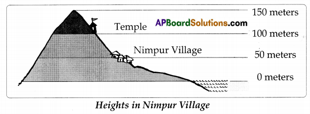
1. How many meters above sea level is the temple?
Answer:
100 meters.
2. How many meters above sea level is the top of the hill?
Answer:
Approximately 150 meters.
50 meters
![]()
Text Book Page No. 5
Question 7.
1. Look at the map of Nimpur showing heights. What is the colour given to the area adjacent to the sea?
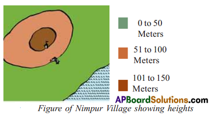
Answer:
Green.
2. What is the colour given to the highest region in this map?
Answer:
Dark brown.
Text Book Page No.5
Question 8.
look at the Physical Map of India or Telangana in your atlas or wall map. Find out the range of heights and colours for the places given below by reading the index and fill the table given below on the basis of your of findings. (Reading the text (‘given), understanding and interpretation)
| Place | Height | Colour Zone |
| Hyderabad | From …………….. to ……………. meters | |
| Khammam | From ………………….. to ……………………… meters | |
| Adilabad | From …………………. to …………………. meters | |
| Nalgonda |
Answer:
| Place | Height | Colour Zone |
| Hyderabad | 600 – 900 meters | Yellow |
| Khammam | 150- 300 meters | Green |
| Adilabad | 600- 900 meters | Yellow |
| Nalgonda | 300- 600 meters | Light Green |
If you have the map of India, find out the height of few capital cities in India.
Answer:
Srinagar – (4,500 – 6000 meters), Gandhinagar – (0- 300 meters) Bhopal – (300- 600 meters), Imphal (900 – 1800 meters), and Chennai – (0- 300 meters).
If you have a World map, find out the height of a few cities from around the world.
Answer:
Washington D.C. – (0 – 200 meters), Brasilia – (400-1000 meters), Adis Ababa – (above 2000 meters), Delhi – (0. 200 meters), and Oslo – (1000 – 2000 meters).
Text Book Page No. 6
Question 9.
Look at the figures given in page 6 and 7 and tell whether Nimpur would be submerged if sea waters were to flooded up to 30 meters
Answer:
No. It is above 50 meters height.
Question 10.
Look at the figure and answer the following questions.
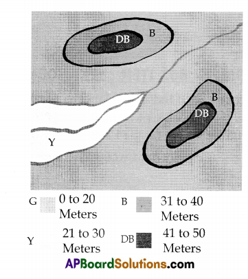
1. Mark the direction of flow of the river.
Answer:
This is the direction of the flow of the river.
(The water flows from high land to low land, here form 21-30 mts to 0 – 20 mts)
2. The height of the lowest land is between meters and meters.
Answer:
0- 20 meters.
3. There are two high points in this map. What are their heights?
Answer:
41 to 50 meters.
Additional Questions
Question 1.
What are the different types of maps?
Answer:
- Political maps: Maps which show only political divisions are called political maps.
- Physical maps: Maps showing landforms like mountains, plateaus, and plains are called physical maps.
- Weather maps: Maps showing the weather conditions of a particular region are called weather maps.
- Population maps: Maps showing the distribution of population of a country or place.
There are many other maps that show crops, climate, routes, and historical places also.
Question 2.
What are the characteristics of the contour lines?
Answer:
- Contour lines will be irregular in shape.
- They cannot cut with each other.
- The distance between two contour Lines depends upon the landscape.
Two Marks Questions
Question 1.
What is a map?
Answer:
When the spherical earth is drawn to a scale on a paper or on any plain surface, it is called a map.
Question 2.
What are the ways used to show heights on maps?
Answer:
Heights on maps are shown in different shades colours to different heights and contour lines.
![]()
Question 3.
What are the uses of maps showing heights?
Answer:
- Maps showing heights help us to understand the nature uf the terrain.
- These are very essential when roads or dams are to be constructed.
Question 4.
What is the Mean Sea Level?
Answer:
The average sea level calculated after observing a long period of high and low tides is called Mean Sea Level.
Question 5.
What is a contour?
Answer:
A contour is a line joining the places having equal heights.
Reading text (given), understanding and interpretation)
Mean Sea Level
There are high tides and low tides on the level of the sea, and they never stand still. As a result of this phenomenon, the level of the sea keeps on either rising or falling. Which of these heights do we take as the sea level or 0-meter height? In order to solve this problem the level of the sea is carefully measured at frequent intervals and the mean level of the sea is calculated. Over a period scientists observed the high and low levels of the sea and they have come to one calculated average level which is known as Mean Sea Level (M.S.L).
Question.
What do you mean by Mean Sea [eve!?
Answer:
- The level of the sea keeps on either rising or falling due to high tides and low tides.
- To solve this problem the level of the sea is carefully measured at frequent intervals.
- Over a period of time, scientists observed and calculated average level.
- That calculated average sea level is known as the Mean Sea Level (M.S.L). Reflection on contemporary issues and questioning
Question.
Why should we study the different kinds of maps?
Answer:
Maps tell us about the location of different places. They are used to show the hot and cool places, how much rainfall the places receive. The maps also tell us the places in which different crops are grown and having different kinds of forests. So, we should study the different kinds of maps.
Information skills
Question 1.
Observe the following table carefully and answer the questions.
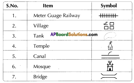
Read the above information and answer the following questions.
1. ![]() symbol indicates ……………………. .
symbol indicates ……………………. .
Answer:
Canal
2. Which Symbol indicates a village?
Answer:

3. Which Symbol indicates Meter Guage Railway line?
Answer:
![]()
4. ![]() Symbol indicates ………………………. .
Symbol indicates ………………………. .
Answer:
Bridge
5. The symbols shown in the table are called
Answer:
Conventional symbols.
![]()
Question 2.
Point, Line, Area: We use symbols to show any physical object on the map. If we are asked to show Delhi in Indian map, we will mark a point (.) and label it as Delhi.
To show the river Manjeera, we draw a line ![]() along its course, for the Railway line we will draw a track line
along its course, for the Railway line we will draw a track line ![]() to represent it. In Telangana map, if we want to show the area of Medak or Hyderabad district, we demarcate its boundary and mark it with some colour or pattern, which is known as a real symbol. Thus all physical objects are shown on the map with the help of a point, line or an area symbol.
to represent it. In Telangana map, if we want to show the area of Medak or Hyderabad district, we demarcate its boundary and mark it with some colour or pattern, which is known as a real symbol. Thus all physical objects are shown on the map with the help of a point, line or an area symbol.
1. What symbol is used to represent a river on a Map?
Answer:
![]() is used to represent a river.
is used to represent a river.
2. How do we show the capital on a map?
Answer:
We mark a dark point like “.” to point out a capital and label it.
3. How do we show the area of Medak on Telangana map?
Answer:
If we want to show the area of MedaL we demarcate its boundary and mark it with some colour or pattern.
4. What symbol is used to point out a railway line?
Answer:
We use ![]() to represent a railway line.
to represent a railway line.
5. How are physical objects shown on the map?
Answer:
The physical objects are shown on the map with the help of a point line or an area symbol.
Question 3.
Contour Lines
A contour is a line joining the places with equal heights. On the map of Nimpur you would have seen that there is a line passing through the village, this is the 50-meter contour line. All places on this line will have the same heights of 50 meters.
Contour lines will be in irregular shape depending upon the Landform. These cannot cut with each other. The distance between two contour lines will depend upon the landscape. If the land has a steep climb, then the contour lines will be near to each other. If the slope of the land is gentle, then the contour lines will be quite far from each other.
1. What is a contour?
Answer:
A contour is a line joining the places with equal heights.
2. What is contour line on the map of Nimpur?
Answer:
On the map of Nimpur, we can see a line passing through the village. This is the 50-meter contour line.
3. What is the shape of contour lines?
Answer:
Contour lines will be in irregular shape depending upon the landform.
4. When will be the contour lines near to each other?
Answer:
If the land has a steep climb, then the contour lines will be near to each other.
5. When will be the contour lines far from each other?
Answer:
If the slope of the land is gentle, then the contour lines will be quite far from each other.
Mapping skills
A) Map Pointing:
Locate the following on the map of India.
1. Hyderabad
2. Chennai
3. Mumbai
4. New Delhi
5. Lucknow
B) Map Reading:
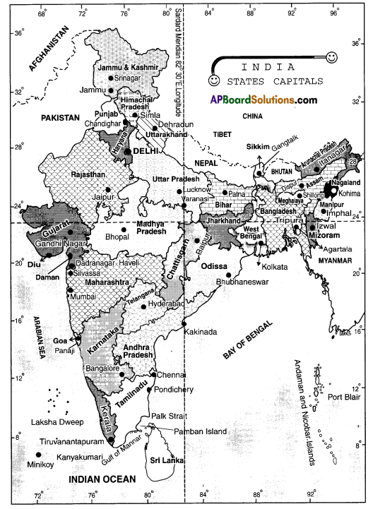
1. Observe the following India map and write the names of South East States.
Answer:
Odessa, Andhra Pradesh, TimiJ Nadu.
2. What are the border states of Tamilnadu?
Answer:
Andhra Pradesh, Karnataka, Kerala.
3. What is the State that lies north of Andhra Pradesh?
Answer:
Telangana.
4. What are the states that are on the shore of Arabian sea?
Answer:
Kerala, Karnataka, Goa, Maharashtra, Gujarat.
5. The islands in India Bay of Bengal ……………. .
Answer:
Andaman and Nicobar islands.
![]()
Work Book
Choose the correct answer:
Question 1.
The maps, that give the information about heights and depths of a place are ……………. .( )
A) Political maps
B) Geographical maps
C) Physical maps
D) Climatic maps
Answer:
B) Geographical maps
Question 2.
All heights are calculated from this level ( )
A) Ground level
B) Sea level
C) Road level
D) Surface level
Answer:
B) Sea level
Question 3.
Different shades of colours are used to depict the following on the map ( )
A) Depths
B) Heights
C) Width
D) Areas
Answer:
D) Areas
Question 4.
A contour line joins ( )
A) places with equal depth
B) places with same climate
C) places with equal heights
D) places with equal population
Answer:
C) places with equal heights
Question 5.
…………………. Tell us about how high or low the places are ( )
A) Maps
B) Globes
C) Plans
D) Books
Answer:
A) Maps
Question 6.
Maps showing distribution of forests are ……………. . ( )
A) Physical Map
B) Thematic Map
C) Atlas
D) Political Map
Answer:
B) Thematic Map
![]()
Question 7.
A contour line Is joining two places M and N. The height of M is 50 meters. Then the height of N is: ( )
A) 150 meters
B) 100 meters
C) 50 meters
D) 25 meters
Answer:
C) 50 meters
Question 8.
‘Yellow’ colour Is used for showing …………… . ( )
A) plateau
B) water
C) plains
D) mountains
Answer:
A) plateau
Question 9.
What does ‘N’ with an arrow show? ( )
A) Direction of East
B) Direction of South
C) Direction of North
D) Direction of West
Answer:
B) Direction of South
Question 10.
PS stands for ………………… . ( )
A) Post Office
B) Post and Telegraph
C) Police Station
D) Police Symbol
Answer:
A) Post Office
Question 11.
…………………… maps show variety of Ian deforms and depict the height of places. ( )
A) Political maps
B) Thematic maps
C) Physical maps
D) Atlas
Answer:
C) Physical maps
Question 12.
All heights on the land are calculated from ……………….. . ( )
A) Sea level
B) Land level
C) Atmospheric level
D) Gmund level
Answer:
A) Sea level
![]()
Question 13.
MSL means ( )
A) Maximum Sea Level
B) Mean Sea Level
C) Minimum Sea Level
D) Monthly Sea Level
Answer:
B) Mean Sea Level