Telangana SCERT TS 6th Class Social Study Material Pdf 1st Lesson Reading and Making Maps Textbook Questions and Answers.
TS 6th Class Social 1st Lesson Questions and Answers – Reading and Making Maps
Improve Your Learning
Question 1.
Collect different kinds of maps and study them. If you have any doubts, clarify them
with your teacher. (Mapping skills)
Answer:
Question 2.
Find out the distance from your mandal headquarters to the district headquarters by converting the map distance into actual distance. (Mapping skills)
Answer:
In the map the distance between our mandal headquarter and the district headquarter is shown as 7 cms.
The scale is shown in the map is 1 cm = 10 kms.
So, the actual distance is 7 cms x 10 kms = 70 kms.
![]()
Question 3.
Why is the actual distance on the ground reduced on the map? (Conceptual understanding)
Answer:
It is impossible to show the actual distance in the map because the area in the map is very little. So, the actual distance is reduced to a scale to make it convenient.
Question 4.
Explain the need of the symbols in preparing maps. (Conceptual understanding,)
Answer:
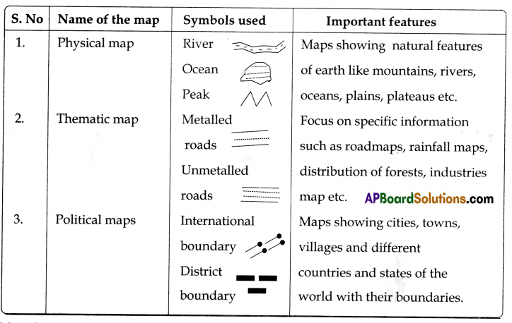
We know that maps are too small for us to draw pictures of the things shown on them. For example, we cannot draw the real school, bus stand, colony, offices, railway station, gardens, farmlands, trees, etc., as it will take too much space on the map. Therefore we have to show things on map with the help of symbols.
eg. : Villages and towns will be shown with dots and circles.
Question 5.
Draw the symbols representing different water bodies, places of worship, and public offices on a drawing sheet and present in the class. (Mapping skills)
Answer:
Water Bodies (Symbols)
canal:

River:
Well:

Tank:

Worshipping Plates (Symbols)
Mosque:

Temple:

church:

Public Offices (Symbols)
Post Office: P.O.
Telegraph Office: T.O.
Rest House: RH.
State Forest: S.F.
Question 6.
Draw a sketch of your house and mark the other houses and places around it in the connect direction.
Answer:
Question 7.
What are the important features of a map? (Conceptual understanding)
Answer:
- The routes and directions will be shown in the map.
- Maps are prepared in such a manner that the north direction is at the top o map.
- Maps always mention the scale.
- Maps are prepared using the conventional symbols.
Question 8.
Read the paragraph titled Symbols’ on page no.6 and comment on it. (Reading the text given), understanding and interpretation)
Symbols
You know that maps are too small for us to draw pictures of the things shown on them, For example, we cannot draw the real school or bus stand or Mallika’s house as it will take too much space on the map. Therefore, we always show things on a map with the help afyrnboIs. You may have noticed that iii the district map. villages and towns are shown with dots and circles. Map makers prepare symbols, appropriate to their needs. But some common symbols which are called ‘Conventional Symbols’, are also used. The following is a complete map with symbols, Scale, and proper orientation:
Answer:
1. It is impossible to draw actual shape and size of different features like buildings, roads, trees, railway lines, or a well on a map. So we use various symbols to show these features.
2. Symbols give much information in a limited space.
3. With the help of these symbols. we can draw maps and read them easily.
4. Without knowing the language of a certain place, we can collect information from maps with the help of these symbols.
Question 9.
Observe the different maps present in Atlas and fill the table with details. (Information Skills)
Answer:
(Project Work)
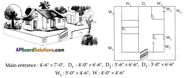
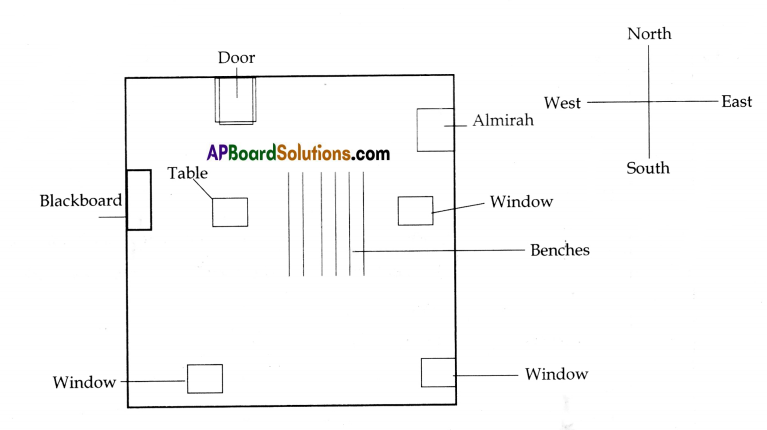
Prepare a map of your classroom using the following instructions:
a) First, find the four directions in your classroom by facing the north.
Answer:
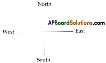
If you stand facing east, all the things to your right are towards south; all the things to your left are towards north; and all the things behind you are towards west.
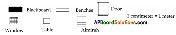
b) Make a list of all the walls, doors, windows, blackboards, almirahs etc. that you want to show on the map. Make symbols for them in your notebook.
Answer:
Walls – 4
Blackboard – 1
Windows – 3
Doors – 1
Almirah – 1
![]()
c) Draw a sketch map of the classroom with walls and location of the objects you want to show. Make sure to draw the northern wall on the top of the sketch.
Answer:
d) Now, split into small groups and measure the length of each wall with the help of a scale. Write down the distances on the sketch map.
Answer:
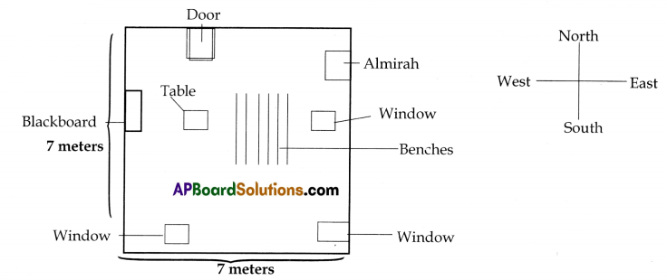
e) Draw a map of the classroom by selecting an appropriate Scale, It can be one centimeter for one meter. So if a wall is 7 meters long, you will have to make a 7 centimeters long line on paper.
Answer:
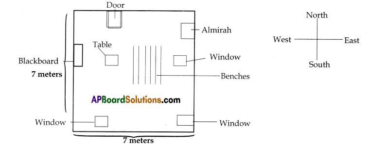
f) After making the outer walls, draw the symbols for windows and doors at the right places. Then draw the symbols for other objects like almirah, blackboard, table, etc.
Answer:
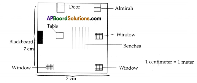
g) Make an index of the symbols you have used in the map and also mention the Scale.
Answer:
h) Compare your map with your friends’ maps and make corrections if there are any.
Answer:
Students activity.
(Intext Questions)
Text Book Page No. 2
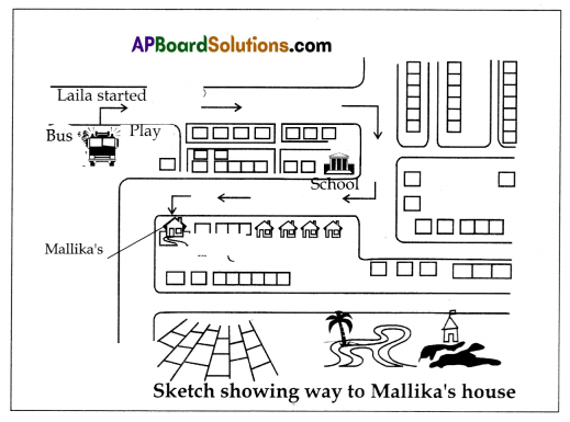
1. Can you reach Mallika’s house from the bus stop with the help of the Sketch map?
Answer:
Yes.
2. How many turns did Lalla Lake to reach Mallika’s house? Are there any landmarks at the turns?
Answer:
3 turns.
3. Are the buildings shown in the sketch drawn to their actual size?
Answer:
No, it is not possible to show them in the sketch.
4. Can you tell the direction In which Laila walked (North or Last)?
Answer:
No, I cannot tell because in the map the directions are not mentioned.
5. Can you tell the distance from the bus stop to Mallika’s house?
Answer:
I cannot say, because it is a sketch map and the scale is not mentioned.
6. Can you tell the distance from the bus stop to Mallika‘s house?
Answer:
Students activity.
Text Book Page No. 3
Question 2.
Directions:
Look at the following picture carefully:
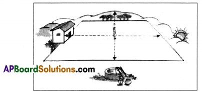
The girl in the middle is lacing the rising Sun. Now fill the following table:
| Direction | Object |
| 1. East | Sun, hills |
| 2. South | Well |
| 3. North | Trees & Hills |
| 4. West | House |
Read the information carefully and answer the questions. (Map Reading)
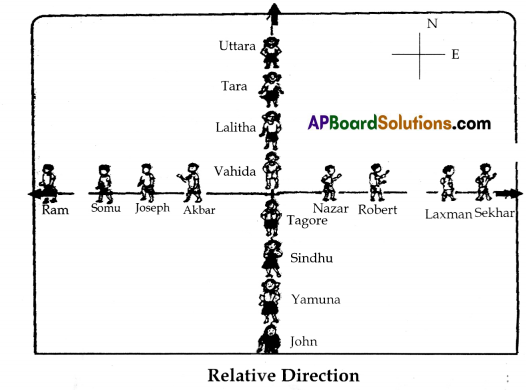
Observe the figure carefully and answer the questions.
1. Lalitha is towards …………. direction of John.
Answer:
North
2. Lalitha is towards ………………. direction of Uttara.
Answer:
South
![]()
3. Nazar is in ………… direction of Sckhar.
Answer:
West
4. Nazar is towards …………… direction of Ram.
Answer:
East
5. Lakshman is towards ……………….. direction of Somu.
Answer:
East
6. Lakshman is also towards ……………….. of Sekhar.
Answer:
west
7. Tara is in the …………….. direction of John.
Answer:
North
Text Book Page No. 4
Question 3.
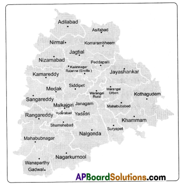
hang a political map of Telangana on the wall. (Map Reading Skills)
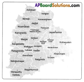
Answer the following questions after looking at the map.
1. In which direction is Mahaboobnagar from Hyderabad?
Answer:
South-West.
2. In which direction is Hydera bad from Medak?
Answer:
South.
3. In which direction is Khammam from Nalgonda?
Answer:
North.
4. Is Karimnagar towards south of Adilabad?
Answer:
Yes, it is on the South.
5. If you want to go from Warangal to Mahabubnagar in which direction will
you travel?
Answer:
South West.
Text Book Page No. 5
In the above sketch, the distance between Mahaboohnagar and Wanaparthy is given in the form of a line The actual distance between these places is 50km. Measure the line joining the two places and find out the distance on the map. Actual distance between Mahahubnagar and Wanaparthy: ……………..
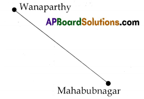
Answer:
50 km.
If it is one cm on the map. what will be the actual distance on the land?
1 cm = ……………….. Km
Answer:
10km.
Text Book Page No. 7
Question 1.
Study the sketch map and answer the following questions. (Map Reading)
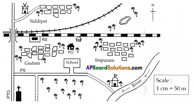
Based on the map given, answer the following questions:
1. In which direction of the church is the river flowing?
Answer:
In East direction.
2. What kind of road is present on the south of Sripuram village?
Answer:
Kutcha road.
3. WhIch type of railway line located near Snpuram?
Answer:
Broad gauge.
4. In which direction of railway station is the police station?
Answer:
In South direction
5. Name the village that lies to the north of the railway track.
Answer:
Siddipet.
![]()
6. Imagine you are in the school shown on the map. Which direction will you face if you are coming out of your school?
Answer:
South. (The school is lacing north)
Question 2.
Locate the following on the given map. (Map Pointing)
1) Adilabad
2) Khammam
3) Hyderabad
4) Karnataka
5) Medak
Answer:
(Additional Questions)
Question 1.
What will happen if we do not know the directions?
Answer:
We don’t know where we are, we cannot explain others in which direction they have to go to reach their destination. Mapping with directions makes easy to travel to an place on the earth.
Question 2.
Explain briefly about reading and making maps?
Answer:
Maps tell us several things about different places like where they are – on the sea, or on a mountain or in a desert how hot or cold, what kind of trees and plants grow, etc. There are different kinds of maps, such as physical maps. administrative maps. historical maps etc.
We can know many details about a pale from maps. If you stand facing to the East, all things to your right-hand side will be towards the South. all things to your left will be towards the North and all things behind you will be lo the West. Usually, maps are prepared in such a manner that the North direction is at the top of the map and the South side is at the bottom. We use scale for showing the actual distance on the ground in a reduced manner on a map. We always show things on a map with the help of symbols.
Map makers prepare symbols appropriate to their needs. But there are some common symbols which are called ‘Conventional symbols’.
(Mapping Skills)
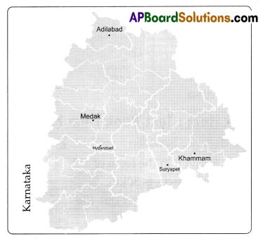
Question 3.
Map Reading:
Observe carefully the map and answer Add the questions.
1. In which direction is Medak from Hyderabad?
Answer:
In the North.
2. In which direction is Hyderabad from Adilabad?
Answer:
In the south.
3. Which district Is there on the North end?
Answer:
Adilahad district
4. How many districts are there in Telangana?
Answer:
31 districts in March 2017.
(Two Mark Questions)
Question 1.
What are the conventional symbols?
Answer:
Some common symbols used in the maps are known as “the conventional symbols”.
Question 2.
Mention the names of some kinds of maps?
Answer:
Physical maps, political maps. historical maps etc…, are some kinds of maps.
Question 3.
What is a map?
Answer:
A map is a representation or a drawing of the total or a part of earth’s surface drawn on a fiat surface according to a scale.
Question 4.
What is a scale?
Answer:
Showing the actual distance on the ground in a reduced manner on a map is known as scale.
Objective Type Questions
Question 1.
We can know about the landforms from this kind of map. ( )
A) physical
B) historical
C) political
D) route
Answer:
A) physical
Question 2.
If you stand facing east, all things behind you will be to ( )
A) the west
B) the north
C) the south
D) the direction
Answer:
A) the west
![]()
Question 3.
Maps are prepared in such a way that the North direction is at the ( )
A) bottom
B) top
C) middle
D) left
Answer:
B) top
Question 4.
The number of districts in Telangana are ( )
A) 31
B) 9
C) 22
D) 23
Answer:
A) 31
Question 5.
At the bottom of the map there will be a mention of ( )
A) quality
B) scale
C) distance
D) temperature
Answer:
B) scale
Question 6.
We show things on a map with the help of ( )
A) symbols
B) signals
C) directions
D) scale
Answer:
A) symbols
Question 7.
‘Conventional symbols means ( )
A) common symbols
B) red signals
C) proper orientation
D) four directions
Answer:
B) red signals
Question 8.
Need of the sketch map or a map is ( )
A) to know the whereabouts of various places.
B) to develop public relations.
C) to maintain secrets.
D) to know the symbols.
Answer:
A) to know the whereabouts of various places.
Question 9.
How do we know the actual distance from a certain place? ( )
A) through the symbol on the map.
B) through the scale mentioned on the map.
C) through the arrow showing the North,
D) through observation.
Answer:
A) through the symbol on the map.
Question 10.
How do we know the directions? ( )
A) when other people show the way.
B) through sketch map.
C) if you stand faring to the rising sun
D) by traveling.
Answer:
A) when other people show the way.
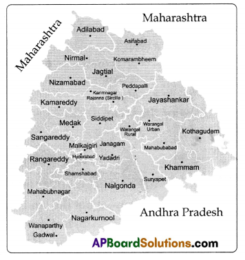
Look at the map and answer the questions 15 – 18
Question 11.
What is the state adjacent to Nalgonda and Khammam ( )
A) Karnataka
B) Chattisgarh
C) Maharashtra
D) Andhra Pradesh
Answer:
B) Chattisgarh
![]()
Question 12.
The state that has no border with Telangana ( )
A) Maharashtra
B) Karnataka
C) Chattisgarh
D) Tamilnadu
Answer:
D) Tamilnadu
Question 13.
On what side is Maharashtra to Telangana state ( )
A) East
B) South
C) North and North West
D) South West
Answer:
C) North and North West
Question 14.
What is the capital of Telangana state ( )
A) Nalgonda
C) Mahaboohnagar
B) Hyderabad
D) Khammam
Answer:
B) Hyderabad