Telangana SCERT 10th Class Social Study Material Pdf Telangana 1st Lesson India: Relief Features Textbook Questions and Answers.
TS 10th Class Social 1st Lesson Questions and Answers – India: Relief Features
Question 1.
The sun rises two hours earlier in Arunachal Pradesh as compared to Gujarat in the west. But the clocks show the same time. How does this happen?
Answer:
- The local times of places which lie on different meridians are bound to differ.
- The sun rises two hours earlier r Arunachal Pradesh as compared to Guaral the west.
- This causes a time loss of two hours from Gujarat to Arunachal Pradesh.
- To avoid confusion due to time differences and to have a standard time for reference, the time along the meridian 82°30′ E passing through Mirzapur in U.P. has been taken as the standard time for the entire country.
- This is why the clocks show the same time.
Question 2.
If the Himalayas weren’t situated where they are now, how would the climatic conditions of the Indian subcontinent be?
Answer:
- The Himalayas affect the climate of india by blocking cold air blowing from the North that comes from Siberia and Central Asia.
- Without the Himalayas, India would get cold temperature in the wnte months.
- The Himalayas form a natural barrier that prevents monsoon winds from going further north.
- The Himalayas are reason for summer rains and monsoon-type climate in the regions that are beyond the Western Ghats of India.
- In its absence, this region would have remained drier.
- India would have been a tropical desert.
Question 3.
Which are the major physiographic divisions of India? Contrast the relief of the Himalayan region with that of the peninsular plateau.
Answer:
The major physiographic divisions of india are:
- The Great Himalayas
- The indo-Gangetic plain
- The Peninsular Plateau
- The Coastal Plains
- The Desert and
- The Islands
| Himalayan region | Peninsular region |
| 1) The Himalayas are located In the northern region of our country. | 1) The Peninsular region is located in the southern region of our country. |
| 2) The Himalayas are young fold mountains of comparatively recent origin. | 2) The central highlands are formed of low hills and there is no high peak of worldwide tame in these hills. |
| 3) Many great perennial rivers like the Indus, the Ganges, and the Brahmaputra originate from the Himalayas. | 3) Some great rivers like the Godavari, the Krishna, the Mahana, the Tapati, and the Narmada originate from these hills. |
| 4) These are formed of the sedimentary rocks. | 4) The central highlands are formed of igneous and metamorphic rocks. |
| 5) They are formed at the edge of the Indo- Gangetic plain. | 5) They are formed at the edge of the Deccan plateau. |
| 6) Important hill stations like – Shimla, Mussoorie, Darjeeling. Nainital are found On the Himalayas. | 6) Udagamandaiam-a hill station is found On these hills. |
![]()
Question 4.
What is the influence of the Himalayas on Indian agriculture?
Answer:
Influence of the Himalayas on Indian Agriculture:
1. Fertile soil: The sediments carried by the Himalayan rivers are deposited in the northern plain in the form of fertile soil, it makes the plain one of the most fertile lands in the world. e.g.: Bhabar, Terai, Bhangar.
2. Source of rivers: The Himalayas act as a huge reservoir of water for the north Indian rivers. Abundant rainfall, vast snowfield, and huge glaciers are the feeding grounds of the mighty rivers of India. All these are perennial rivers and lifelines of north India.
3. This region Is suitable for construction of multipurpose protection which strengthens the Indian agriculture.
4. The Himalayan ranges keep the country warm by obstructing the northern winds. This helps Indian agriculture to cultivate many varieties of crops.
Question 5.
Indo- Gangetic plains have a high density of population. Find the reasons.
Answer:
- This area in south Asia is extremely fertile and excellent for farming.
- This makes the Indo-Gangetic plain a heaven for Indian farmers to grow rice and wheat.
- The plain supports high density of the population as it is very easy to build on.
Question 6.
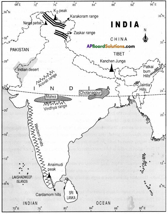
On an outline map of India. show the following:
(i) Mountain and hill ranges – the Karakoram, the Zaskar, the Patkai Bum, the Jainhia. the Vlndhya range, the Aravali, and the Cardamom hills
(ii) Peaks – K2, Kanchenjunga, Nanga Parbat and the Anaimudi.
(iii) Plateaus Chotanagpur and Maiwa
(iv) The Indian Desert. Western Ghats, Lakshadweep Islands
Answer:
Question 7.
Use an atlas and identity the following:
i) The Islands formed due to Volcanic eruption.
ii) The countries constituting the Indian Subcontinent.
iii) Th. states through which the Tropic of Cancer passes.
iv) The northernmost latitude In degrees.
v) The southernmost latitude of the Indian mainland in degrees.
vi) The eastern and the westernmost longitude in degrees.
vii) The place situated on the three seas.
viii) The strait separating Sri Lanka from India.
ix) The Union Territories of India.
x) The states in which the Himalayas are extended to
Answer:
i) The Islands formed due to Volcanic eruption:
e.g.:
- Narcondam and Barren Islands
- Surtsey: the southern coast of Iceland
- Hawaii island
- Thera island
- Montserrat island, etc.
ii) The countries constituting the Indian subcontinent:
- Bangladesh
- Sri Lanka
- Maldives
- Nepal
- Bhutan
- Pakistan
- Tibet (China)
- Myanmar
iii) The Tropic of Cancer passes through these Indian states:
- Gujarat
- Rajasthan
- Madhya Pradesh
- Chattisgarh
- Jharkhand
- West Bengal
- Tripura
- Mizoram
iv) The northernmost latitude in degrees:
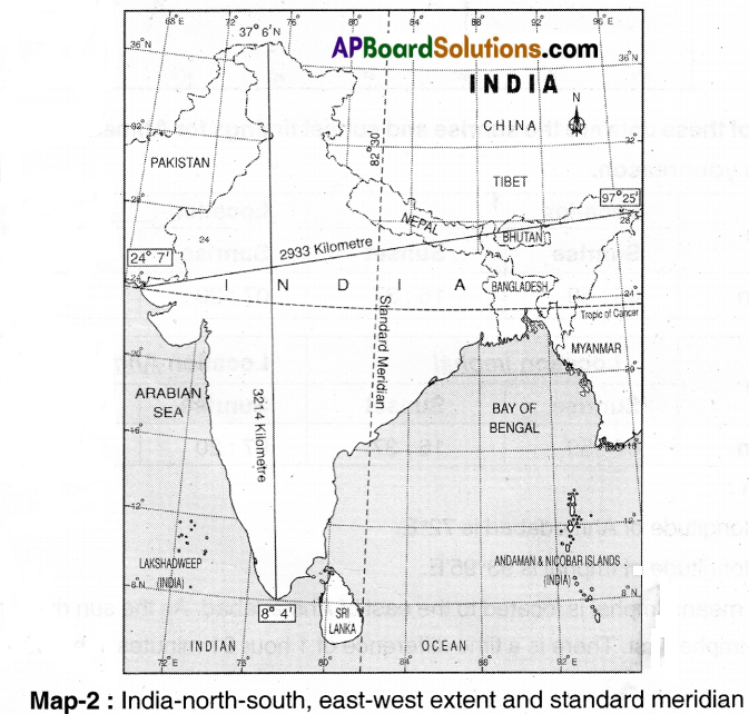
The nethermost latitude ¡n degrees : 37°6′ N
v) The southernmost latitude of the Indian mainland In degrees:
The southernmost latitude of the Indian mainland in degrees: 8°4′
vi) The eastern and the westernmost longitude in degrees:
Easternmost Longitude: 97°25′
Westernmost Longitude: 68°7′
vii) The place situated on the three seas:
Kanyakumari.
viii) The strait separating Sri Lanka from India:
The Palk strait separates Sri Lanka from India.
ix) The Union Territories of India:
- Andaman & Nicobar Islands
- Chandigarh
- Dadra and Nager Haveli
- Damai, & Diu
- Lakshadweep
- NCT of Delhi
- Puckicherry
- Ladakh
- Jammu and Kashmir
x) The states In which the Himalayas are extended to The Himalayas are extended into, Jammu Kashmir. Himachal Pradesh. Nagaland, Manipur and Meghalaya in India.
![]()
Question 8.
How are the Eastern coastal plains and western coastal plains similar or different?
(OR)
Write about the similarities and differences between East Coastal Plains and West Coastal Plains.
Similarities:
- They are the physical features of India
- They both lie in the southern part of India.
- They both lie near to the coast.
Differences:
| Eastern Coastal Plains | Western Coastal Plains |
| 1) Eastern coastal plains belt of plain region lying towards the east between Eastern Ghats and Bay of Bengal. | 1) Western coastal plains is a belt of plain region lying towards the west between Western Ghats and Arabian Sea. |
| 2) Eastern coastal plains are comparatively wider. | 2) This belt of plains Is narrow in width. |
| 3) Eastern coastal plains are very fertile because rivers like Mahanadi, Godavari, Krishna, Cauvery depost their sediments during delta formation. | 3) Western coastal plains are less fertile because no major river is engaged in sediment deposition. |
| 4) Eastern plains receive comparatively lesser rainfall. | 4) Western plains receive more rainfall. |
| 5) From north to south. Eastern coastal plains are divided into Utkal coast, Circar coast, and Coromandel coast. | 5) From north to south, Western coastal plains are divided into Konkan coast, Canara coast arid Malabar coast. |
Question 9.
Plateau regions In India do not support agriculture as much as the plain regions – what are the reasons for this?
Answer:
- Plateau regions in India do not support agriculture as much as the plain regions.
- There are many reasons for this.
- The physical formation of plateau is not much support to agriculture.
- Plains are formed with alluvial soils which are very fertile, so support agriculture.
- The rugged surface of plateau makes irrigation difficult whereas plains provide many irrigation facilities.
- Plateau region does not have any perennial rivers, whereas plain regions have perennial rivers.
- Plateau region is rich in mineral resources whereas plains are rich in agriculture practice.
Question 10.
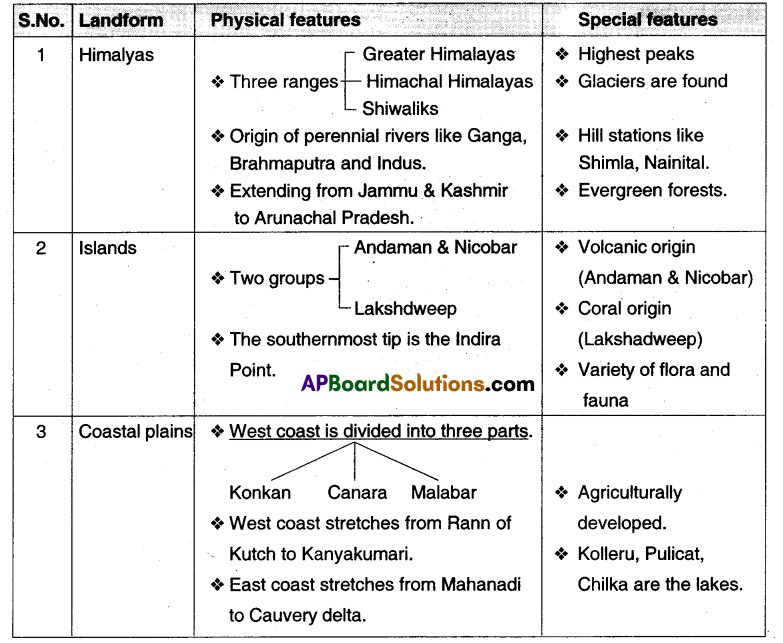
Read about the Himalayas, Islands, and Coastal plains and prepare a detailed table.
Answer:
Question 11.
“Himalayas play a vital role In India’s development” comment.
Answer:
- The seasonal cycles of accumulation of ice, movement, and melting of glaciers are the sources of the perennial rivers.
- The Himalayas influence India’s climate in different ways,
- They protect the great plains of India tram the cold winds of central Asia during severe winter.
- They cause for surrender rains and monsoon type of climate.
- The perennial rivers bring a lot of silt, making the plains very fertile.
- The fertile plains are useful for cultivation.
- The valleys are useful for orchards and growing vegetables.
- The hill stations attract the tourists so as to increase tourism.
- The rivers are useful in producing hydel power. ‘
- Hence it is said that the Himalayas play a vital role in India’s development.
Project
Using the raised relief map, and physical maps in your atlas make clay! sand models of India on the ground. Use different types of sand or soil to mark different types of relief features. Ensure that the heights of the places are proportional and rivers are marked. Look at the vegetation map in your atlas and try to use leaves and grasses to decorate them. Maybe over the year, you can also add other features of India into them.
Answer:
Students’ Activity.
TS 10th Class Social 1st Lesson India: Relief Features Intext Questions
Page No.1
Question 1.
Look at the world map given below and write a few lines about India’s location with reference to the places marked on this map.
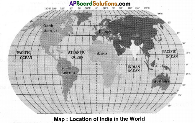
Answer:
India is located to the north of the equator between 8°4′ and 37°6′ north latitudes and 97°25′ east longitudes. The Tropic of Cancer passes through the middle (almost) of the country. Apart from the mainland, the Andaman and Nicobar Islands and Lakshadweep are also parts of India.
Page No. 2
2. The lines of latitude and longitude are used for accurately specifying location of any place or region. Use the atlas and correct the following statement :
“India is a very extensive country and lies totally in the Southern Hemisphere ot the globe. The country’s mainland lies between 8 degrees N and 50 degrees N longitude and 68 degrees 5 and 9 degree E latitude.”
Answer:
India is a very extensive country and he’s totally m the Northern Hemisphere and the Eastern hemisphere of the globe. The country’s mainland lies between 8°4′ and 37°6′ north latitudes and 68°7′ and 97°25′ east longitudes.
Question 3.
Why do we often use the term Indian peninsula”?
Answer:
Any country which is surrounded by sea on three sides and the fourth side is landlocked, is called peninsula. India is surrounded by the Bay of Bengal. the Indian Ocean and the Arabian Sea as its three borders and the fourth edo Is landlocked with the Himalayan mountains. So we often use that term Indian peninsula.
Question 4.
Examine the map (Text P.1) and imagine that India is located in the Arctic Circle. How would your life be different?
Answer:
For humans that live in the Arctic, conditions there dictate the lifestyle to a very great extent. We must cope with very low temperatures and darkness in the winter and temperatures above freezing and constant daylight In the summer. Diet Is based on foods that can be taken from the natural environment since agriculture is impossible. I think my life would be totally different in all the angles.
![]()
Question 5.
Identify Indira Point on the atlas. What is special about this?
Answer:
- In Andaman and Nicobar Islands, Narcondam and Barren Islands are volcanic origin.
- The southernmost tip of Inca found In Nicobar Island is called Indira Point.
- It is named in honour of Smt. Indira Gandhi.
- It was submerged during the 2004 Tsunami.
Question 6.
Telangana lies between and …….. N ……………………… latitudes and and E longitudes.
Answer:
Telangana lies between 15°.55′ and 19°.56’ N latitudes and 77°.15′ and 80°.46′ E longitudes.
Question 7.
Using the scale given in your atlas, estimate the length of the coastline for Gujarat and Odisha.
Answer:
The length of the coastline loi’ Gujarat:1214.7 kms.
The length of the coastline to’ Odisha: 560 kms.
Question 8.
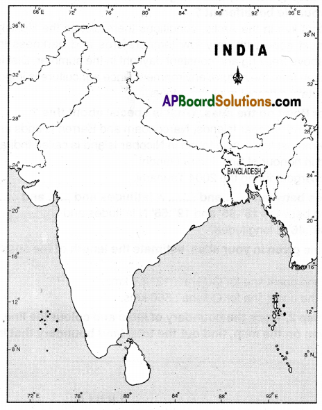
Look at the map 2. Trace the boundary of India and colour the line. With the help of the scale given on the map, find out the total land boundary that India shares with Bangladesh.
Answer:
The total land boundary that India shares with Bangladesh is 4,096.70 km.
Question 9.
Which of these data are the sunrise and sunset timings for Alimedabad and Imphal? Explain your reason.

Answer:
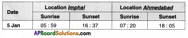
Reason:
The longitude of Ahmedabad is 72°E.
The longitude of Imphal Is 93°95’E.
That means Imphal is located to the east of Ahmedabad. As the sun rises in the east it
rises in Implial first. There is a time difference of hour 21 minutes in between these two places.
Page No. 4
Question 10.
List the Himalayan rivers and the Peninsular rivers that helped the formation of North Indian Plain.
Answer:
The Himalayan rivers that helped the formation of North Indian Plain are
- Indus and its tributaries, the Jhelum, the Chenab. the Ravi, the Boas and the Sutlej.
- The Ganga and its tributaries, the Ghaggar, the Teesta, the Sone, the Kosi and the Yamuna river.
- The Brahmaputra and its tributaries.
- A majority of the tributaries of the Ganga may originate n the Himalayan ranges but some of them have their sources in the peninsular plateau.
- The peninsular rivers that helped the formation of Northern plain are the Charnbal, the Sind, the Beiwa, the Ken, and the Son originating in the northern part peninsula belong to the Ganga river system.
Question 11.
The formation of Himalayas was …………………. million years ago while early hunter-gathering human beings emerged on earth million years ago.
Answer:
200;1.8
Page No.5
Question 12.
Look at the raised relief map! atlas of India in your school. Using your finger, trace the regions mentioned below
a) Follow the course of Godavari and Krishna rivers to identify the direction of slope of Deccan plateau.
Answer:
The direction of slope of Deccan plateau is West to East.
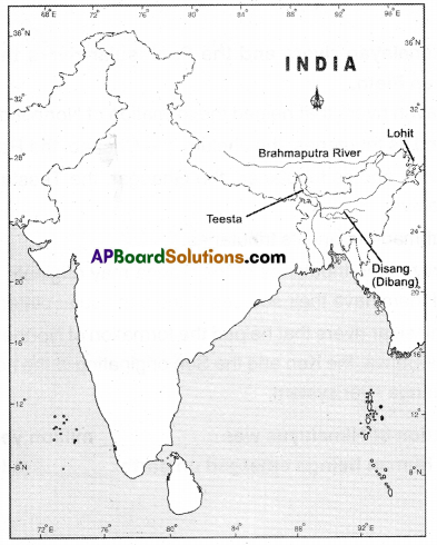
b) Describe the entire course of the Brahmaputra River, with reference to landforms, heights and countries.
Answer:
Brahmaputra river. Bengali Jamuna, Assamese Dihang, Tibetan Tsangpo, Chinese (Pinyin) Yarlung Zano Jiang, or Ya-lu-tsang-pu Chiang. is a major river of central and south Asia. It flows some 1,800 miles from its source in the Himalayas to its confluence with the Ganges river, after which the mingled water of the two rivers empty into the Bay of Bengal. Along its course, it passes through the Tibet autonomous region of China, the Indian states of Arunachal Pradesh, and Assom, and Bangladesh.
For most of its length, the river seems as an important inland waterway. It is not, however, navigable, between the mountains of Tibet and the plains of India. In its lower course, the river is both a creator and a destroyer depositing huge quantities of fertile alluvial sod and also causing disastrous and frequent floods.
Its source:
The Chemayungdung glacier.
Three headstreams:
The Kubi. the Angsi and the Ctìemayungdung.
its tributaries:
Dibang,
Lohit,
Toasta, etc.
Question 13.
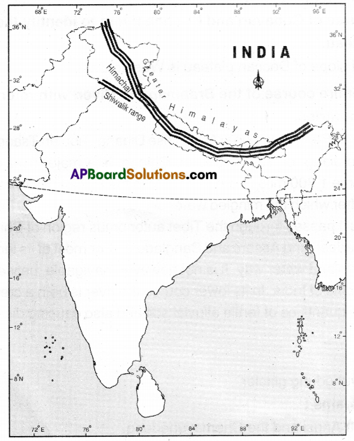
Locate the three ranges in your atlas.
Answer:
- Greater Himalayas or Himadri,
- Himachal Himalayas,
- Shiwaliks.
Question 14.
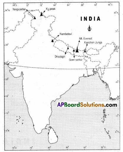
Locate some of the highest peaks in the raised relief map.
Answer:
Mt. Everest, K2 (Gowdin Austin), Kanchenjunga, Gowrisankar, Nanga Parbat. Dhaulagiri and Nandadevi.
Question 15.
Trace the above regions in the raised relief map and on the wall map with your fingers.
Answer:
Student& Activity.
![]()
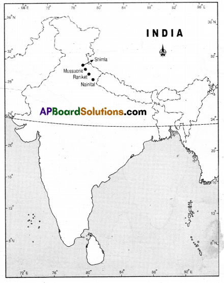
Question 16.
Locate the following places on the physical map of India In your atlas: Shimla, Mussuone, Nainital, and Ranikhet
Answer:
Page No. 8
Question 17.
Locate the following ranges on the physical map of India.
| Hills | State/States |
| Purvanchal | |
| Patkai | |
| Naga hills | |
| Manipur hills |
Answer:
| Hills | State/States |
| Purvanchal | Arunachal Pradesh, Assam, Nagaland, Manipur, Mizoram, Meghalaya. Tripura. |
| Patkai | Assam, Arunachal Pradesh. |
| Naga Hills | Nagaland. |
| Manipur hills | Mizoram. |
Page No. 10
Question 18.
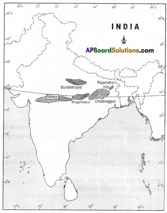
Locate the following on the physical map of India and on the raised relief map:
Matwa plateau, Bundelkhand, Bhagelkhand. Rajamahal Hills and Chotanagpur plateau
Answer:
Question 19.
Using an atlas, compare the relative heights of above plateaus with that of Tibetan plateau.
Answer:
- Height of Tibetan Plateau – More than 4500 mts
- Height of Malwa Plateau – Above 800 mis
- Height of Bundelkhand – 300 to 450 rnts
- Height of Bhagelkhand – 300 to 450 mts
- Height of Rajamahal hills – 1200 to 1646 mts
- Height of Chotanagapur Plateau – 700 mts
Page No.11
Question 20.
Look at the raised / relief map of India and compare the relative height of the Western and the Eastern Ghats as well as Tibetan plateau and Himalayan peaks.
Answer:
a) In features the average height of Western Ghais i& more than 2000 Mts.
b) The average height of Eastern Ghats rarely exceeds 900 Mts.
c) The height of worlðs highest tableland, the Tibetan plateau is above 4500 Mts.
d) The Himalayan peaks are of three ranges.
- In Himadri, the average height of peaks is 6100 Mts.
- In Himachal, the average height of peaks is 4000 Mts.
- In Shiwaliks the average height of peaks is around 1000 Mts.
Heights of the Himalayan Peaks:
- Mt. Everest 8,848 mts
- K2: 8,611 mts
- Kanchenjunga : 8,586 mts
- Lhotse: 8,516 mts
- Malcalu: 8A62 mts
- Cha Oyu: 8,201 mts
- Dhaulagiri : 8,167 mts
- Manaslu: 8.156 mts
- NangaParlat : 8,126mts
- Annapuma : 8.091 mts. etc.
![]()
Page No. 13
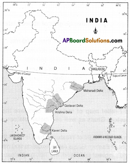
Question 21.
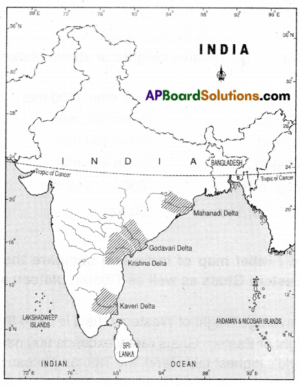
On the physical map of India, identify the delta regions. How is their height similar or different? How do they compare in relation to the Indo-Gangetic plains?
Answer:
Elevation of the Godavari Delta and the Krishna Delta is O mts from the Mean See Level Elevation of the Indo-Gangetic plains is 300 mts. from the Mean Sea Level.
Reason:
Deltas are formed at the mouth of the rivers.
But plains are relatively on higher elevation.