
SCERT AP Board 7th Class Social Solutions 1st Lesson Reading Maps of Different Kinds Textbook Questions and Answers.
AP State Syllabus 7th Class Social Studies Solutions 1st Lesson Reading Maps of Different Kinds
7th Class Social Studies 1st Lesson Reading Maps of Different Kinds Textbook Questions and Answers
Improve Your Learning
Question 1.
Why are the levels of all the seas equal in the world?
Answer:
All heights on the land are calculated from the sea level. Since all seas in the world are connected to each other, more or less the sea level (the top surface) all over the world is taken to be roughly the same.
We can easily observe this in the picture given below.
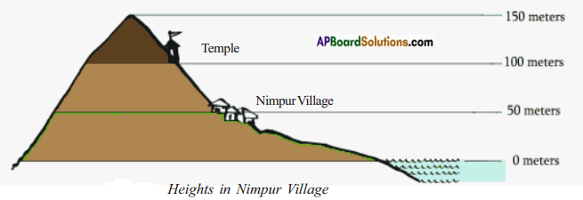
The temple is 100 meters high above sea level. The top of the hill is 150 meters high from sea level.
Thus we can say the levels of all the seas are equal in the world.
![]()
Question 2.
How is the sea level measured?
Answer:
The level of the sea keeps changing. So the level of the sea is carefully measured at frequent intervals and the mean level of the sea is calculated. A tidal gauge is used to measure the rising and falling of the sea.
Question 3.
What are the uses of maps showing heights?
Answer:
- These maps help us to understand the nature of the terrain, where the mountains are, where the valleys are, etc.
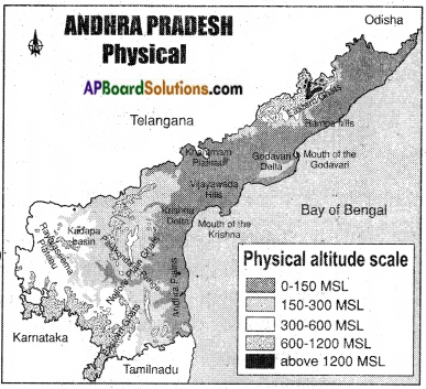
- If we look at the physical map of Andhra Pradesh, we can identify the coastal plains that run along the coast of the Bay of Bengal.
- If we travel westwards from the coast, we will reach hills that form the “escarpments” to the plateau region.
- The plateau region itself is cut by many rivers like the Krishna and the Godavari which form deep and broad valleys in them.
- Maps showing heights are very essential when roads or dams have to be constructed.
- If we have to lay roads in an undulating region between two places, such maps help us in deciding the route to be taken by the road.
- Similarly, when dams are planned it is necessary to know how much land will be submerged by the water of the dam.
Question 4.
What differences do you find between the lifestyle of people living on high altitudes and low altitudes?
Answer:
Difference between the people living on the high and low altitudes:
| People of High Altitudes | People of Low Altitudes |
| 1) They live in mountainous regions. | 1) They live in plains. |
| 2) They are economically backward. | 2) They are economically well developed. |
| 3) They wear woolen clothes. | 3) They wear cotton and silk clothes. |
| 4) They enjoy insecure life. | 4) They enjoy secure life. |
![]()
Question 5.
How are maps helpful to people?
Answer:
- The map is a representation or a drawing of the total or a part of the earth’s surface drawn on a flat surface according to a scale.
- Maps help us to study a part of the earth.
- Maps provide more information than a globe.
- Maps are easy to carry and take the measurement too.
- Some maps tell us about how high or low the places are, some tell us about how much it rains there or how hot or cold it gets there.
- Some maps tell us about crops that grow there or the kinds of forests there are.
- By studying them we can know much about a place.
Question 6.
Read the para ‘Contour Lines’ and comment on it.
Contour Lines
A contour is a line joining the places with equal heights. On the map of Nimpur you would have seen that there is a line passing through the village, this is the 50-meter contour line. All places on this line will have the same height of 50 meters. Contour lines will be in irregular shape depending upon the landform. These cannot cut with each other. The distance between two contour lines will depend upon the landscape. If the land has a steep climb then the contour lines will be near to each other. If the slope of the land is gentle, then the contour lines will be quite far from each other.
Answer:
A contour line of a function of two variables is a curve along which the function has a constant value. In cartography, a contour line joins points of equal elevation above a given level, such as mean sea level.
Contour lines are curved, straight or a mixture of both lines on a map describing the intersection of a real surface with one or more horizontal plains.
![]()
Question 7.
Observe the physical map of Andhra Pradesh and list out the districts which are above 150 M.S.L.?
Answer:
The following districts are above 150 mts Mean Sea level.
- Chittoor
- Visakhapatnam
- Kurnool
- Anantapur.