These AP 6th Class Social Important Questions 4th Lesson Land Forms – Andhra Pradesh will help students prepare well for the exams.
AP State Syllabus 6th Class Social Important Questions 4th Lesson Land Forms – Andhra Pradesh
Question 1.
What is our state song?
Answer:
Maa Telugu Talliki Mallepudanda is a bur State song.
Question 2.
What does our state song describe?
Answer:
Our state song describes the rivers and the rich heritage of our state.
![]()
Question 3.
What does relief of the region mean?
Answer:
Relief of region means the shape of the surface of the earth.
Question 4.
What is the other name of relief of region?
Answer:
Landforms are the other name of relief of region.
Question 5.
Where is Andhra Pradesh situated?
Answer:
Andhra Pradesh is situated in the east coastal line of South India.
Question 6.
What are the boundaries of our state?
Answer:
Chattisgarh, Odisha is in the north, Tamilnadu in the south, Telangana is in the west and north – west, and Karnataka is in the South – West and Bay of Bengal are in the east are the boundaries of our state.
Question 7.
What is the length of the coastal line of Andhra Pradesh?
Answer:
The length of the coastal line of Andhra Pradesh is 972 km.
![]()
Question 8.
On the basis of physical and economic conditions into how many parts can Andhra Pradesh be divided. What are they?
Answer:
On the basis of physical and economic conditions, Andhra Pradesh can be divided into two parts. They are :
- Coastal Andhra Pradesh and
- Rayalaseema.
Question 9.
Write about Coastal Andhra Pradesh.
Answer:
Coastal Andhra Pradesh consists of 9 districts. This region has the fertile soils of the Godavari, Krishna, and Penna Delta. The density of the population is also very high.
Question 10.
Write about Rayalaseema.
Answer:
Rayalaseema is a group of 4 districts. This region comprises rocky and drylands. The uncertain and less rainfall is not favorable for agriculture. So, this land is known for droughts and famines.
Question 11.
Describe mountains.
Answer:
The Mountain range contains severed hills. A mountain is a natural elevation of the earth’s surface. Mountains may have a small summit and a broad base. It is considerably higher than the surrounding area.
Y.S.R. Kadapa, Chittoor, Kurnool, and Vijayanagaram districts have stretches of hilly terrain which we can see as pockets of scattered hills called the Eastern Ghats.
Arakuloya, Borra caves of Vishakhapatnam district, and Papikondalu of East and West Godavari are the famous tourist places in the mountain region.
![]()
Question 12.
Where is Lambasingi situated and why it is famous?
Answer:
Lambasingi was situated in the interior tribal hamlet in Chintapalli Mandal of the Visakhapatnam agency. It has recorded single-digit temperatures in the winter like in Kashmir. So it is also known as Kashmir of Andhra Pradesh.
Question 13.
Who are Chenchus?
Answer:
The Chenchus are a tribal group practicing a pre-agricultural mode of economy. The government of India recognized them as a particularly vulnerable Tribe. They have been the inhabitants of the Nallamala forest area. They are hunter-food gatherers. They spread over the districts of Kurnool, Guntur, and Prakasam in Andhra Pradesh.
Question 14.
What Is a plateau? Describe.
Answer:
A plateau is an elevated flat land. It is a flat-topped table land standing above the surrounding area. A plateau may have one or more sides with steep slopes. The height of plateaus often varies from a few hundred meters to several thousand meters. Like mountains, plateaus also may be differentiated as young or old. The Deccan plateau in India is the oldest plateau and it is of volcanic origin. A large part of Rayalaseema is located in this Deccan plateau region.
Question 15.
Write a few lines about the Deccan plateau.
Answer:
Deccan plateau is the oldest plateau in India. The Deccan plateau is a lava plateau. The larger part of Rayalaseema comes under the Deccan plateau region.
![]()
Question 16.
Describe the plateau region.
Answer:
Plateaus are very useful because they are rich in mineral deposits. Many of the mining areas are located in the plateau areas. Limestone, manganese, asbestos, iron ore, gold, diamonds, graphite, dolomite, quartz, silica sand are available in plateau regions. The lava plateaus are rich in black soil. They are fertile and good for cotton cultivation. Many plateaus have scenic spots and are great tourist attractions.
Question 17.
What are Plains? Describe.
Answer:
Plains are level lands with flat surfaces. These are densely populated areas as flatlands are suitable for building houses, as well as cultivation. Because of fertile soils, the land is highly productive. Construction of transportation facilities is also easy.
In Andhra Pradesh, several districts are situated in the plains. Our state has a long stretch of plains called ‘Coastal Plains’ stretching from Srikakulam district in the North to the Pulicat Lake in the South.
Question 18.
What is Kharif and Rabi?
Answer:
Paddy monsoon crop is called Kharif and the winter monsoon crop is called Rabi.
Question 19.
What is a horticulture hub?
Answer:
Horticulture hub is an area where plantation crops, especially ready-to-harvest crops like banana, mango, guava, and papaya crops are grown.
Question 20.
What are the main rivers of Andhra Pradesh?
Answer:
Krishna and The Godavari is the main rivers of Andhra Pradesh. They flow from the Western ghats and join into the Bay of Bengal in the east by forming a large delta.
![]()
Question 21.
What is ‘Podu’?
Answer:
Podu is an ancient agricultural practice in the hilly regions. It is also called shifting or jhuming cultivation. In this method, the people clear a patch of land and use it to grow crops for one or two years and later shift to some other place.
Question 22.
How are the soils in the delta region get enriched?
Answer:
Every year the floodwaters of the river enrich the soils of the delta region. The floods bring silt-laden with humus with them. They deposit it in the flooded areas. In this way, the floods enrich the soils of the delta region.
Question 23.
How crops can be grown throughout the year in plain areas?
Answer:
Plain areas receive plenty of rainfall from June to October from the Southwest monsoon. Besides rainfall, bore wells and canals provide plenty of water for agriculture. Warm temperature and good sunshine make it possible to grow crops throughout the year.
Question 24.
Why plain areas are important for agriculture?
Answer:
Plain areas are important for agriculture because alluvial soils are deposited as sediments in these plains. They are deep and fertile, and the flatness facilitates mechanizes of crop production. They also support grasslands which provide good grazing for livestock.
![]()
Question 25.
Why soils in plateau areas are not suitable for cultivation?
Answer:
Soils in plateau areas are of two types: red and saline soils. These soils cannot hold much water. So fields in the Rayalaseema region are left to be uncultivated. Saline soils have a high content of lime and salts. They cannot absorb water and are not suitable for any crop.
Question 26.
Which crops can be cultivated in hilly areas and why?
Answer:
In hilly areas, the soils are uneven and sloped. These soils belong to red and rocky. Because of their high elevation and the natural downward movement of water, these soils are mostly well-drained and suitable for plantation crops like coffee and tea.
Question 27.
What are the sources of water in plateaus and hilly regions?
Answer:
In plateaus sources of water are rainfall, borewells, and tanks. In hilly regions source of water is only rainfall.
Question 28.
What are the famous tourist places in the mountain region of Andhra Pradesh?
Answer:
Borra caves of Visakhapatnam district and Papikondalu of East and West Godavari districts are the famous tourist places in these mountain regions.
![]()
Question 29.
What is a drought-prone region?
Answer:
A region that receives low and uncertain rainfall is called a drought-prone region.
Question 30.
What is the difference between a cash crop and a food crop?
Answer:
Cash Crop gives more income or profit to the farmer. It is also known as a commercial crop. Ex: Groundnut, turmeric, sugarcane, tobacco, etc.
A food crop is a crop grown for consumption. Ex: Paddy, millets, vegetables, etc.
Question 31.
What is known as aquaculture? What is the effect shown by aquaculture?
Answer:
The rearing of aquatic animals for food is known as aquaculture. Ex: Fish, prawn, shrimp, crabs, etc. Most of the farmers in coastal districts are shifting to aquaculture. Most of the paddy-growing fields are converted into aquaculture ponds. This change is resulting in water pollution and contamination of water ponds in paddy-grown areas.
Question 32.
What is the impact of a landform on people’s lives?
Answer:
Change in landforms impacts the wellness of a region, occupation, and food patterns. The plant and animal wealth of a place also depends upon the natural habitat and the climate that prevails in that region. Food, clothing, occupation, and livelihood of the people are closely connected with the regional and physical surroundings and climate.
![]()
Question 33.
What is Mean Sea Level (MSL)?
Answer:
The height of a surface from the sea is called Mean Sea Level. India’s mean elevation is 160 m (525 ft) and is taken from Mumbai High.
Question 34.
Write a brief note on landforms of Andhra Pradesh.
Answer:
- Andhra Pradesh is situated in the east coastal line of India.
- Andhra Pradesh has varied landforms.
- The important landforms are Deccan Plateau in the South West.
- The Eastern Ghats towards the mid-eastern part.
- Eastern coastal plains in the east where the land descands down into the Bay of Bengal.
- Thus our state has mountains/hills, plains, and plateaus as major landforms.
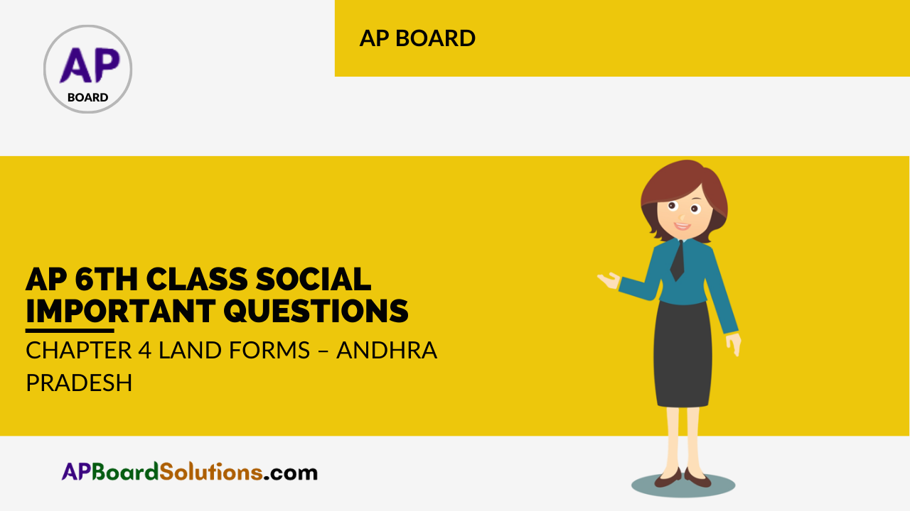
Question 35.
Locate the Fast coastal plains In the below map.
Answer:
![]()
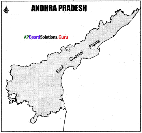
Question 36.
Locate the following places in the Andhra Pradesh outline map.
A) the Eastern Ghats
B) East Coastal Plains
C) Amaravathi
D) Armakonda
Answer:
Question 37.
Read the information and answer the following questions.
| S.No. | Name of the Hills | Name of the District |
| 1. | Yarada and Ananthagiri hills | Visakhapatnam |
| 2. | Bison hills and Papikondalu | East and West Godavari |
| 3. | Mogalrajapuram, Kondapalli hills | Krishna |
| 4. | Berumkonda, Nagarjunakonda and Kotappakonda | Guntur |
| 5. | Velikondalu | SPSR Nellore |
| 6. | Nallamala, Erramala | Kurnool |
| 7. | Velikondalu and Palakondalu | YSR Kadapa |
| 8. | Seshachalam and Horsely hills | Chittoor |
| 9. | Penukonda and Madakasira hills | Ananthapuram |
1. In which district Nagarjunakonda is situated?
Answer:
Guntur district.
2. What is the other name of Bison hills?
Answer:
Papikondalu.
3. What are the hills situated in the SPSR Nellore district?
Answer:
Velikondalu.
4. What are the hills situated in the Chittoor district?
Answer:
Seshachalam and Horsely hills.
5. Name the hills situated in Visakhapatnam district?
Answer:
Yarada and Anantagiri hills.
6. How many types of hills are there in Andhra Pradesh?
Answer:
There are nine types of hills.
7. Name the hills situated in SPSR Nellore district.
Answer:
Velikondalu is situated in the SPSR Nellore district.
8. Where are Seshachalam Hills?
Answer:
Seshachalam hills are in the Chittoor district.
9. Where can we find Ananta Giri Hills?
Answer:
We can find Anantagiri hills in the Visakhapatnam district.
![]()
Question 38.
Mention any two groups, even now treated as nomads.
Answer:
- It is a strange experience to know that some groups of people are still nomads in the 21st century.
- There are a good number of nomads on the Earth.
- Chenchus of Andhra Pradesh (Nallamala forest area) is one of the wondering groups for hunting and food gathering.
- Erukula is another sect of nomads.
They travel with a group of families by selling medicines with donkey milk, dolls with palm leaves, etc.
Question 39.
Read the map and answer the following questions.
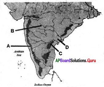
1. What is the area represented by A?
Answer:
The Western Ghats.
2. What is the area represented by B?
Answer:
Deccan plateau.
3. What is the area represented by C?
Answer:
The Eastern Ghats.
4. What is the area represented by D?
Answer:
Coastal plains.
![]()
Question 40.
Read the passage and answer the following question.
Lammasingi / Lambasingi, the interior tribal hamlet in Chintapalli Mandal of Visakhapatnam agency, has recorded single-digit temperatures in the winter. It is also known as ‘Kashmir of Andhra Pradesh’.
★ Write some other hill stations like Lambasingi.
Answer:
- Horsely hills near Gurram Konda of Chittoor district is famous. Hill resort is famous for its cool temperature in summer.
- Mahendra Giri is one of the highest peaks in our state in Odisha Border.
- Tirumala, Simhachalam, Gundala, Kotappakonda, Vijayawada (Kanaka Durga Temple) are some of the spiritual centers on hills stations.
- Aruku Valley is famous for its pleasant climate and beautiful sceneries.
Question 41.
Appreciate the Diversity in lifestyles of Andhra Pradesh.
Answer:
- Andhra Pradesh has different landforms.
- We must appreciate the people for selecting their economic activities depending upon the physical and climatic features of their region.
- People living in the plains thrive on agriculture.
- People in the coastal areas depend on fishing.
- Charcoal batti, making of cement bricks are in the plateau region.
- Collection of forest products and animal rearing are some of the economic activities in the mountain region.
Question 42.
Read the map and answer the following questions.
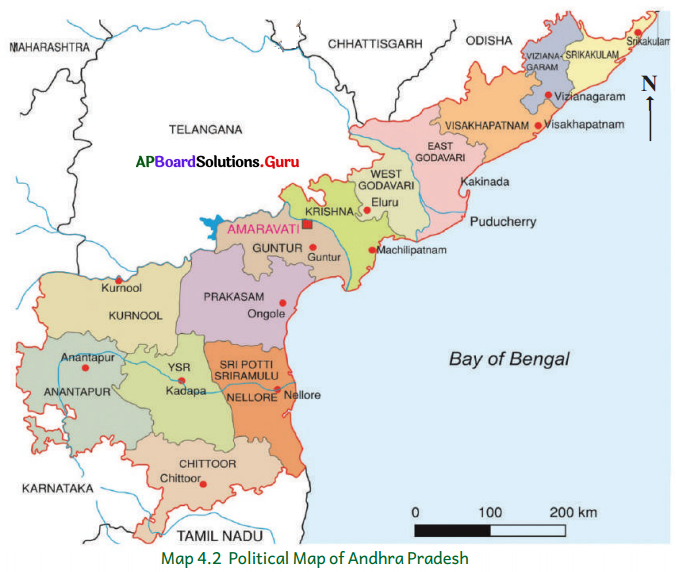
a) In which district Amaravathi is located?
Answer:
Amaravathi is located in the Guntur district.
b) Which district has the boundary with Chattisgarh state?
Answer:
East Godavari district done has a boundary with Chattisgarh state.
c) What are the border districts of Karnataka State?
Answer:
Kurnool, Anantapuram, and Chittoor are the border districts of Karnataka.
![]()
Question 43.
How can you say that the tribal people follow distinct cultures?
Answer:
- The tribal people follow distinct cultures of their own.
- They do not destroy the forests they use.
- Their lifestyle is eco-friendly.
- They use naturally available things like medicines.